![](/images/other/stat-length.png)
![Trail Mountain bike Saintes - Entre Vignes et Fleuve - Photo](https://media.geolcdn.com/t/1900/400/ext.pjpeg?maxdim=2&url=https%3A%2F%2Fstatic1.geolcdn.com%2Fsiteimages%2Fupload%2Ffiles%2F1524743154velo.jpg)
Entre Vignes et Fleuve
alboss
User
![Length](/images/other/stat-length.png)
Length
35 km
![Max alt](https://static1.geolcdn.com/siteimages/upload/files/1508320355ic_sort_altitude_max_24dp.png)
Max alt
61 m
![Uphill gradient](https://static1.geolcdn.com/siteimages/upload/files/1508320355ic_sort_den_pos_24dp.png)
Uphill gradient
361 m
![Km-Effort](/images/other/stat-length.png)
Km-Effort
40 km
![Min alt](https://static1.geolcdn.com/siteimages/upload/files/1508320355ic_sort_altitude_min_24dp.png)
Min alt
-1 m
![Downhill gradient](https://static1.geolcdn.com/siteimages/upload/files/1508320355ic_sort_den_neg_24dp.png)
Downhill gradient
361 m
![Boucle](https://static1.geolcdn.com/siteimages/upload/files/16400158638029165_repeat_loop_refresh_sync_direction_icon.png)
Boucle
Yes
Creation date :
2020-08-21 19:54:52.658
Updated on :
2020-08-21 19:58:51.442
![Mountain bike](https://static1.geolcdn.com/sitytour/trail-icons/202.png)
2h42
Difficulty : Difficult
![Scan this QR Code to open this trail in the SityTrail application](https://capi.geolives.com/qq0zvz2zws4bq2lad0pu/sitytour/trails/2523169/qr.png?size=200)
FREE GPS app for hiking
About
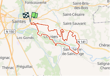
Trail Mountain bike of 35 km to be discovered at New Aquitaine, Charente-Maritime, Saintes. This trail is proposed by alboss.
Description
Départ et arrivée parking Intermarché "Lamothe" .
Réalisable seulement si les bacs de Dompierre et Chaniers sont en service.
Positioning
Country:
France
Region :
New Aquitaine
Department/Province :
Charente-Maritime
Municipality :
Saintes
Location:
Unknown
Start:(Dec)
Start:(UTM)
686432 ; 5068034 (30T) N.
Comments
Trails nearby
![Trail Equestrian La Chapelle-des-Pots - Circuit des potiers - La Chapelle des Pots - Photo](https://media.geolcdn.com/t/375/260/ext.jpg?maxdim=2&url=https%3A%2F%2Fservices.sitytrail.com%2FGeolivesWS%2FDownloadMedia.ashx%3FTrailID%3D112268%26Media%3D10265_6.jpg)
![Equestrian Equestrian](https://static1.geolcdn.com/sitytour/trail-icons/300.png)
Circuit des potiers - La Chapelle des Pots
Equestrian
Easy
(1)
La Chapelle-des-Pots,
New Aquitaine,
Charente-Maritime,
France
![](/images/other/stat-length.png)
7.2 km | 8.5 km-effort
1h 19min
![](https://static1.geolcdn.com/siteimages/upload/files/16400158638029165_repeat_loop_refresh_sync_direction_icon.png)
Yes
![Trail Walking La Chapelle-des-Pots - la Chapelle des Pots ( D ROUSSET) - Photo](https://media.geolcdn.com/t/375/260/ext.jpg?maxdim=2&url=https%3A%2F%2Fstatic1.geolcdn.com%2Fsiteimages%2Fupload%2Ffiles%2F1553511878bg_sport_marche.png)
![Walking Walking](https://static1.geolcdn.com/sitytour/trail-icons/101.png)
la Chapelle des Pots ( D ROUSSET)
Walking
Medium
(1)
La Chapelle-des-Pots,
New Aquitaine,
Charente-Maritime,
France
![](/images/other/stat-length.png)
7.8 km | 8.8 km-effort
2h 40min
![](https://static1.geolcdn.com/siteimages/upload/files/16400158638029165_repeat_loop_refresh_sync_direction_icon.png)
Yes
![Trail Walking Saintes - Voiville - Pessines 01 022023 - Photo](https://media.geolcdn.com/t/375/260/ext.jpg?maxdim=2&url=https%3A%2F%2Fstatic1.geolcdn.com%2Fsiteimages%2Fupload%2Ffiles%2F1553511878bg_sport_marche.png)
![Walking Walking](https://static1.geolcdn.com/sitytour/trail-icons/101.png)
Voiville - Pessines 01 022023
Walking
Medium
(1)
Saintes,
New Aquitaine,
Charente-Maritime,
France
![](/images/other/stat-length.png)
7.8 km | 8.8 km-effort
2h 22min
![](https://static1.geolcdn.com/siteimages/upload/files/16400158638029165_repeat_loop_refresh_sync_direction_icon.png)
Yes
![Trail Walking Chaniers - port huble - Photo](https://media.geolcdn.com/t/375/260/ext.jpg?maxdim=2&url=https%3A%2F%2Fmedia.geolcdn.com%2Ff%2Fba0c962b-94d4-49b1-ba68-5d28da08b6da.jpg)
![Walking Walking](https://static1.geolcdn.com/sitytour/trail-icons/101.png)
port huble
Walking
Medium
Chaniers,
New Aquitaine,
Charente-Maritime,
France
![](/images/other/stat-length.png)
5.6 km | 6.5 km-effort
1h 39min
![](https://static1.geolcdn.com/siteimages/upload/files/16400158638029165_repeat_loop_refresh_sync_direction_icon.png)
Yes
![Trail Walking La Chapelle-des-Pots - La Chapelle des Pots - Asphodèles - Photo](https://media.geolcdn.com/t/375/260/ext.jpg?maxdim=2&url=https%3A%2F%2Fstatic1.geolcdn.com%2Fsiteimages%2Fupload%2Ffiles%2F1553511878bg_sport_marche.png)
![Walking Walking](https://static1.geolcdn.com/sitytour/trail-icons/101.png)
La Chapelle des Pots - Asphodèles
Walking
Easy
(1)
La Chapelle-des-Pots,
New Aquitaine,
Charente-Maritime,
France
![](/images/other/stat-length.png)
7.4 km | 8.7 km-effort
2h 5min
![](https://static1.geolcdn.com/siteimages/upload/files/16400158638029165_repeat_loop_refresh_sync_direction_icon.png)
Yes
![Trail Walking Saintes - saintes (essais 01) - Photo](https://media.geolcdn.com/t/375/260/ext.jpg?maxdim=2&url=https%3A%2F%2Fstatic1.geolcdn.com%2Fsiteimages%2Fupload%2Ffiles%2F1553511878bg_sport_marche.png)
![Walking Walking](https://static1.geolcdn.com/sitytour/trail-icons/101.png)
saintes (essais 01)
Walking
Very easy
(1)
Saintes,
New Aquitaine,
Charente-Maritime,
France
![](/images/other/stat-length.png)
9 km | 10.4 km-effort
2h 1min
![](https://static1.geolcdn.com/siteimages/upload/files/16400158638029165_repeat_loop_refresh_sync_direction_icon.png)
Yes
![Trail Walking Saintes - JFT YB Etape11 8-5 -2014 - Photo](https://media.geolcdn.com/t/375/260/ext.jpg?maxdim=2&url=https%3A%2F%2Fservices.sitytrail.com%2FGeolivesWS%2FDownloadMedia.ashx%3FTrailID%3D280229%26Media%3Dfix__20140508074818.jpg)
![Walking Walking](https://static1.geolcdn.com/sitytour/trail-icons/101.png)
JFT YB Etape11 8-5 -2014
Walking
Medium
Saintes,
New Aquitaine,
Charente-Maritime,
France
![](/images/other/stat-length.png)
30 km | 33 km-effort
6h 10min
![](https://static1.geolcdn.com/siteimages/upload/files/16400158638029165_repeat_loop_refresh_sync_direction_icon.png)
No
![Trail Mountain bike La Chapelle-des-Pots - Circuit des potiers - La Chapelle des Pots - Photo](https://media.geolcdn.com/t/375/260/ext.jpg?maxdim=2&url=https%3A%2F%2Fservices.sitytrail.com%2FGeolivesWS%2FDownloadMedia.ashx%3FTrailID%3D112267%26Media%3D10265_6.jpg)
![Mountain bike Mountain bike](https://static1.geolcdn.com/sitytour/trail-icons/202.png)
Circuit des potiers - La Chapelle des Pots
Mountain bike
Easy
La Chapelle-des-Pots,
New Aquitaine,
Charente-Maritime,
France
![](/images/other/stat-length.png)
7.2 km | 8.5 km-effort
34min
![](https://static1.geolcdn.com/siteimages/upload/files/16400158638029165_repeat_loop_refresh_sync_direction_icon.png)
Yes
![Trail Walking La Chapelle-des-Pots - Circuit des potiers - La Chapelle des Pots - Photo](https://media.geolcdn.com/t/375/260/ext.jpg?maxdim=2&url=https%3A%2F%2Fservices.sitytrail.com%2FGeolivesWS%2FDownloadMedia.ashx%3FTrailID%3D112266%26Media%3D10265_6.jpg)
![Walking Walking](https://static1.geolcdn.com/sitytour/trail-icons/101.png)
Circuit des potiers - La Chapelle des Pots
Walking
Medium
La Chapelle-des-Pots,
New Aquitaine,
Charente-Maritime,
France
![](/images/other/stat-length.png)
7.2 km | 8.5 km-effort
2h 0min
![](https://static1.geolcdn.com/siteimages/upload/files/16400158638029165_repeat_loop_refresh_sync_direction_icon.png)
Yes