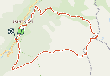
![](/images/other/stat-length.png)
![Trail Walking Belvédère - Boucle St Grat-cime du Diable-Capelets-vacherie. - Photo](https://media.geolcdn.com/t/1900/400/ext.pjpeg?maxdim=2&url=https%3A%2F%2Fstatic1.geolcdn.com%2Fsiteimages%2Fupload%2Ffiles%2F1553511878bg_sport_marche.png)
Boucle St Grat-cime du Diable-Capelets-vacherie.
ch2slv
User
![Length](/images/other/stat-length.png)
![Max alt](https://static1.geolcdn.com/siteimages/upload/files/1508320355ic_sort_altitude_max_24dp.png)
![Uphill gradient](https://static1.geolcdn.com/siteimages/upload/files/1508320355ic_sort_den_pos_24dp.png)
![Km-Effort](/images/other/stat-length.png)
![Min alt](https://static1.geolcdn.com/siteimages/upload/files/1508320355ic_sort_altitude_min_24dp.png)
![Downhill gradient](https://static1.geolcdn.com/siteimages/upload/files/1508320355ic_sort_den_neg_24dp.png)
![Boucle](https://static1.geolcdn.com/siteimages/upload/files/16400158638029165_repeat_loop_refresh_sync_direction_icon.png)
![Walking](https://static1.geolcdn.com/sitytour/trail-icons/101.png)
10h14
Difficulty : Difficult
![Scan this QR Code to open this trail in the SityTrail application](https://capi.geolives.com/qq0zvz2zws4bq2lad0pu/sitytour/trails/2522854/qr.png?size=200)
FREE GPS app for hiking
About
Trail Walking of 14.6 km to be discovered at Provence-Alpes-Côte d'Azur, Maritime Alps, Belvédère. This trail is proposed by ch2slv.
Description
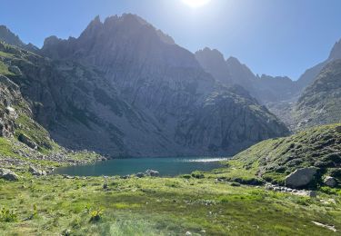
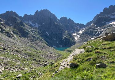
Longue boucle au départ de la vacherie, montée longue et "costaud" à la fin, par la jolie Maïris, le vallon de Verrairiers et le pas deTrem. Juste après le raidillon est "cassant". Vue somptueuse depuis la Cime du Diable (sauf si nuages...). Descente côté Sud. Contournement du Capelet Sup et Inf non tracé (à éviter si brouillard et sans carte IGN sur GPS).
Très longue portion en devers pentu (Dahu?)😕😥mais c'est quand même plus sympa que les éboulis des Verrairiers, surtout à partir des crêtes du Capelet inf . Après descente en crête très agréable.
Le tracé passe par 2 racourcis peu marqués mais bien plus rapides.
Positioning
Comments
Trails nearby
![Trail On foot Saint-Martin-Vésubie - SityTrail - Lacs de Prals - Photo](https://media.geolcdn.com/t/375/260/ext.jpg?maxdim=2&url=https%3A%2F%2Fstatic1.geolcdn.com%2Fsiteimages%2Fupload%2Ffiles%2F1545311037marcheuse_200dpi.jpg)
![On foot On foot](https://static1.geolcdn.com/sitytour/trail-icons/100.png)
On foot
![](/images/other/stat-length.png)
![](https://static1.geolcdn.com/siteimages/upload/files/16400158638029165_repeat_loop_refresh_sync_direction_icon.png)
![Trail Walking Belvédère - Via Alpina - D60: Belvédère > Col de Turini - Photo](https://media.geolcdn.com/t/375/260/ext.jpg?maxdim=2&url=https%3A%2F%2Fservices.sitytrail.com%2FGeolivesWS%2FDownloadMedia.ashx%3FTrailID%3D109715%26Media%3D4424_1.jpg)
![Walking Walking](https://static1.geolcdn.com/sitytour/trail-icons/101.png)
Walking
![](/images/other/stat-length.png)
![](https://static1.geolcdn.com/siteimages/upload/files/16400158638029165_repeat_loop_refresh_sync_direction_icon.png)
![Trail Walking Saint-Martin-Vésubie - Boucle Les lacs de Prals par la cime de la Vallette - Photo](https://media.geolcdn.com/t/375/260/2c298eac-1e8e-4f8d-83e4-c08337da9759.jpg&format=jpg&maxdim=2)
![Walking Walking](https://static1.geolcdn.com/sitytour/trail-icons/101.png)
Walking
![](/images/other/stat-length.png)
![](https://static1.geolcdn.com/siteimages/upload/files/16400158638029165_repeat_loop_refresh_sync_direction_icon.png)
![Trail On foot Belvédère - Les Merveilles par la Gordolasque - Photo](https://media.geolcdn.com/t/375/260/530d04a7-b615-4962-acf5-9f79fcad8eda.jpeg&format=jpg&maxdim=2)
![On foot On foot](https://static1.geolcdn.com/sitytour/trail-icons/100.png)
On foot
![](/images/other/stat-length.png)
![](https://static1.geolcdn.com/siteimages/upload/files/16400158638029165_repeat_loop_refresh_sync_direction_icon.png)
![Walking Walking](https://static1.geolcdn.com/sitytour/trail-icons/101.png)
Walking
![](/images/other/stat-length.png)
![](https://static1.geolcdn.com/siteimages/upload/files/16400158638029165_repeat_loop_refresh_sync_direction_icon.png)
![Trail Walking Belvédère - Pont du Countet refuge de Nice et Lacs du Mont Clapier - Photo](https://media.geolcdn.com/t/375/260/e630815b-37c0-4f3c-a885-04147e40707a.jpg&format=jpg&maxdim=2)
![Walking Walking](https://static1.geolcdn.com/sitytour/trail-icons/101.png)
Walking
![](/images/other/stat-length.png)
![](https://static1.geolcdn.com/siteimages/upload/files/16400158638029165_repeat_loop_refresh_sync_direction_icon.png)
![Trail Walking Saint-Martin-Vésubie - Lacs de Prals - Photo](https://media.geolcdn.com/t/375/260/ext.jpg?maxdim=2&url=https%3A%2F%2Fservices.sitytrail.com%2FGeolivesWS%2FDownloadMedia.ashx%3FTrailID%3D452352%26Media%3D84506a50-74df-4ea2-b935-71761b13f9a6.jpg)
![Walking Walking](https://static1.geolcdn.com/sitytour/trail-icons/101.png)
Walking
![](/images/other/stat-length.png)
![](https://static1.geolcdn.com/siteimages/upload/files/16400158638029165_repeat_loop_refresh_sync_direction_icon.png)
![Trail Walking Belvédère - Tête Nord du Basto - Photo](https://media.geolcdn.com/t/375/260/5640154e-6254-40fc-b00f-576bc1b0aa4a.jpg&format=jpg&maxdim=2)
![Walking Walking](https://static1.geolcdn.com/sitytour/trail-icons/101.png)
Walking
![](/images/other/stat-length.png)
![](https://static1.geolcdn.com/siteimages/upload/files/16400158638029165_repeat_loop_refresh_sync_direction_icon.png)
![Trail Walking Belvédère - Cime Niré - Photo](https://media.geolcdn.com/t/375/260/c9039c2c-28f7-41da-888a-5098e0336ff0.jpg&format=jpg&maxdim=2)
![Walking Walking](https://static1.geolcdn.com/sitytour/trail-icons/101.png)
Walking
![](/images/other/stat-length.png)
![](https://static1.geolcdn.com/siteimages/upload/files/16400158638029165_repeat_loop_refresh_sync_direction_icon.png)