Trail Walking Wildenstein - Wildenstein - Steinwasen  (20/8/2020) - Photo

Wildenstein - Steinwasen (20/8/2020)

© OpenStreetMap contributors
Length
Length
17.8 km
Max alt
Max alt
1302 m
Uphill gradient
Uphill gradient
899 m
Km-Effort
Km-Effort  
30 km
Min alt
Min alt
623 m
Downhill gradient
Downhill gradient
894 m
Boucle
Boucle
Yes
Creation date :
2020-08-20 07:29:44.284
Updated on :
2020-08-21 12:23:55.822

(0 Reviews)

Walking
Walking
5h26
Difficulty : Medium

Scan this QR Code to open this trail in the SityTrail application

FREE GPS app for hiking

Logo SityTrail SityTrail

IGN / Geographical institutes

Download SityTrail from the App Store Download SityTrail from Google Play

Logo SityTrail SityTrail World

The world is yours!

Download SityTrail from the App Store Download SityTrail from Google Play Download SityTrail on Huawei AppGallery

About

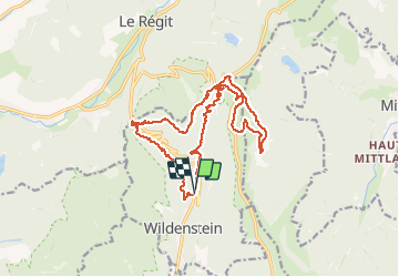
Trail Walking of 17.8 km to be discovered at Grand Est, Haut-Rhin, Wildenstein. This trail is proposed by Richard68500.

Description

direction Wildenstein au fond de la vallée de Thann à l'assaut.....
- du col du Bramont (Le col de Bramont est un col du massif des Vosges, situé à 955 m d'altitude).
- du col de l'Etang (Altitude: 1020m)
- du col du Rothenbachkopf (Le Rothenbachkopf est un sommet du massif des Vosges situé à cinq kilomètres
au sud du Hohneck, et à une altitude de 1 316 m. La crête du Rothenbachkopf, située entre Wildenstein et Mittlach)
pour midi arrivé à la ferme auberge du Steinwasen (tél: 03 89 77 62 68) pour notre traditionnel plat du jour.

Elevation profile

Photos

Positioning

Country:
France
Region :
Grand Est
Department/Province :
Haut-Rhin
Municipality :
Wildenstein
Location:
Unknown
Start:(UTM)
348147 ; 5316651 (32T) N.

Trails nearby

Trail Walking La Bresse - 2023-04-16 Marche Abri Lac de Blanchemer vers Lac de Lispach - Photo
Walking
GUIDE
holtzv

Walking

Very difficult
(1)
La Bresse, Grand Est, Vosges, France
23 km | 36 km-effort
8h 4min
No
Trail Walking La Bresse - 2023-04-15 Marche Abri Collet de Etang vers Abri Lac de Blanchemer - Photo
Walking
GUIDE
holtzv

Walking

Medium
(1)
La Bresse, Grand Est, Vosges, France
22 km | 35 km-effort
7h 51min
No
Trail Walking Wildenstein - 2022-02-20 Marche Kruth Grand Ventron - Photo
Walking
GUIDE
holtzv

Walking

Very difficult
(1)
Wildenstein, Grand Est, Haut-Rhin, France
16.8 km | 27 km-effort
4h 52min
Yes
Trail Walking La Bresse - Autour du Lac des Corbeaux - Photo
Walking
Alfredy

Walking

Medium
(1)
La Bresse, Grand Est, Vosges, France
3.1 km | 6 km-effort
1h 30min
Yes
Trail Walking La Bresse - Kastelberg des pierres, des lacs, des panoramas magnifiques  - Photo
Walking
Alfredy

Walking

Difficult
(1)
La Bresse, Grand Est, Vosges, France
15.1 km | 26 km-effort
6h 11min
Yes
Trail Walking Wildenstein - Col du Bramont - Machey - Blanchemer - Photo
Walking
VacheKiri67

Walking

Medium
(1)
Wildenstein, Grand Est, Haut-Rhin, France
15.3 km | 22 km-effort
4h 27min
Yes
Trail Mountain bike La Bresse - randonnée découverte à la Bresse.  - Photo
Mountain bike
Dutyrider

Mountain bike

Easy
(1)
La Bresse, Grand Est, Vosges, France
30 km | 41 km-effort
2h 58min
Yes
Trail Walking La Bresse - Rainkopf - Mittlach - Hohneck - Photo
Walking
tracegps

Walking

Difficult
(1)
La Bresse, Grand Est, Vosges, France
22 km | 41 km-effort
8h 0min
Yes
Trail Walking La Bresse - Le Lac des Corbeaux - La Bresse - Photo
Walking
tracegps

Walking

Medium
(2)
La Bresse, Grand Est, Vosges, France
3 km | 6 km-effort
2h 0min
Yes


Close
My subscriptions