Trail Walking Lus-la-Croix-Haute - Le Col de Charnier - Photo
 patjobou
patjobou

User

© OpenStreetMap contributors
Length
Length
9.9 km
Max alt
Max alt
2108 m
Uphill gradient
Uphill gradient
959 m
Km-Effort
Km-Effort  
23 km
Min alt
Min alt
1233 m
Downhill gradient
Downhill gradient
963 m
Boucle
Boucle
Yes
Creation date :
2020-08-20 06:35:30.744
Updated on :
2020-08-20 19:41:25.144

(0 Reviews)

Walking
Walking
6h00
Difficulty : Difficult

Scan this QR Code to open this trail in the SityTrail application

FREE GPS app for hiking

Logo SityTrail SityTrail

IGN / Geographical institutes

Download SityTrail from the App Store Download SityTrail from Google Play

Logo SityTrail SityTrail World

The world is yours!

Download SityTrail from the App Store Download SityTrail from Google Play Download SityTrail on Huawei AppGallery

About

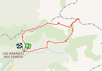
Trail Walking of 9.9 km to be discovered at Auvergne-Rhône-Alpes, Drôme, Lus-la-Croix-Haute. This trail is proposed by patjobou.

Description

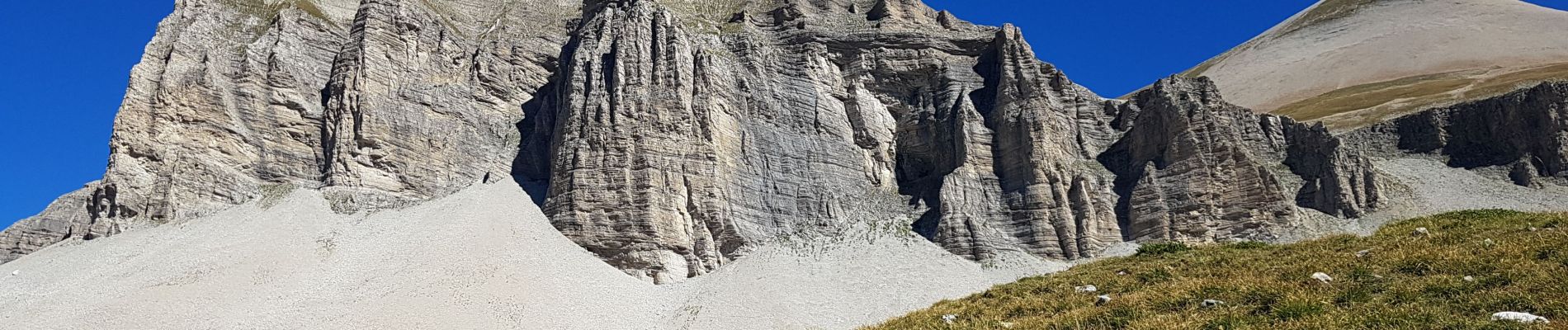
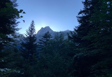
Une belle boucle avec des paysages typiques du Dévoluy. La montée au dessus de la cabane du Fleyrard est soutenue; il faut parfois chercher le sentier, on le trouve assez souvent ... à moins que ce soit des traces de moutons.... En s'écartant un peu du col du Charnier, on peut apercevoir le Grand Ferrand derrière l'imposante et aride Tête de Vallon Pierra.

Elevation profile

Photos

Positioning

Country:
France
Region :
Auvergne-Rhône-Alpes
Department/Province :
Drôme
Municipality :
Lus-la-Croix-Haute
Location:
Unknown
Start:(UTM)
720233 ; 4952410 (31T) N.

Trails nearby

Trail Walking Lus-la-Croix-Haute - R41   le lac de Lauzon - Photo
Walking
GUIDE+

Walking

Difficult
Lus-la-Croix-Haute, Auvergne-Rhône-Alpes, Drôme, France
8.1 km | 18.7 km-effort
3h 40min
Yes
Trail Walking Lus-la-Croix-Haute - R38   Col des Aiguilles depuis Lus - Photo
Walking
GUIDE+

Walking

Medium
Lus-la-Croix-Haute, Auvergne-Rhône-Alpes, Drôme, France
5.6 km | 15 km-effort
2h 53min
Yes
Trail Walking Lus-la-Croix-Haute - R37   Col de la Croix - Photo
Walking
GUIDE+

Walking

Medium
Lus-la-Croix-Haute, Auvergne-Rhône-Alpes, Drôme, France
3.7 km | 7 km-effort
1h 27min
Yes
Trail Walking Le Dévoluy - cabane col des Aiguilles La Jarjatte  - Photo
Walking
Atchoum26

Walking

Difficult
Le Dévoluy, Provence-Alpes-Côte d'Azur, Hautes-Alpes, France
12.8 km | 21 km-effort
5h 32min
No
Trail Walking Lus-la-Croix-Haute - MAS REBUFAT - POINTE FEUILLETTE  - Photo
Walking
RD78-38

Walking

Medium
Lus-la-Croix-Haute, Auvergne-Rhône-Alpes, Drôme, France
11.7 km | 20 km-effort
3h 33min
Yes
Trail Walking Lus-la-Croix-Haute - vallon jarjatte. lac lozon. col la croix - Photo
Walking
Matamimi

Walking

Very difficult
Lus-la-Croix-Haute, Auvergne-Rhône-Alpes, Drôme, France
9 km | 19.9 km-effort
6h 31min
No
Trail Walking Tréminis - Le col de La Croix - Photo
Walking
dominiq

Walking

Difficult
Tréminis, Auvergne-Rhône-Alpes, Isère, France
8.8 km | 16.5 km-effort
3h 31min
Yes
Trail Walking Lus-la-Croix-Haute - Pic de l'Aigle en circuit - Photo
Walking
Emelle

Walking

Medium
Lus-la-Croix-Haute, Auvergne-Rhône-Alpes, Drôme, France
7.4 km | 16.2 km-effort
4h 17min
Yes
Trail Walking Lus-la-Croix-Haute - col du charnier et lac lauzet - Photo
Walking
gibello

Walking

Medium
Lus-la-Croix-Haute, Auvergne-Rhône-Alpes, Drôme, France
10 km | 23 km-effort
6h 4min
Yes


Close
My subscriptions