![](/images/other/stat-length.png)
![Trail Walking Saint-Aubin-Celloville - Saint-Aubin-Celloville vers Saint-Adrien et retour - Photo](https://media.geolcdn.com/t/1900/400/b87b9f20-fc57-4c0d-b30c-0a8be90badd3.jpg&format=pjpeg&maxdim=2)
Saint-Aubin-Celloville vers Saint-Adrien et retour
MichelRando7656
User
![Length](/images/other/stat-length.png)
Length
11.8 km
![Max alt](https://static1.geolcdn.com/siteimages/upload/files/1508320355ic_sort_altitude_max_24dp.png)
Max alt
153 m
![Uphill gradient](https://static1.geolcdn.com/siteimages/upload/files/1508320355ic_sort_den_pos_24dp.png)
Uphill gradient
232 m
![Km-Effort](/images/other/stat-length.png)
Km-Effort
14.9 km
![Min alt](https://static1.geolcdn.com/siteimages/upload/files/1508320355ic_sort_altitude_min_24dp.png)
Min alt
8 m
![Downhill gradient](https://static1.geolcdn.com/siteimages/upload/files/1508320355ic_sort_den_neg_24dp.png)
Downhill gradient
234 m
![Boucle](https://static1.geolcdn.com/siteimages/upload/files/16400158638029165_repeat_loop_refresh_sync_direction_icon.png)
Boucle
Yes
Creation date :
2020-08-20 11:16:13.847
Updated on :
2020-08-20 15:17:59.711
![Walking](https://static1.geolcdn.com/sitytour/trail-icons/101.png)
4h00
Difficulty : Difficult
![Scan this QR Code to open this trail in the SityTrail application](https://capi.geolives.com/qq0zvz2zws4bq2lad0pu/sitytour/trails/2521658/qr.png?size=200)
FREE GPS app for hiking
About
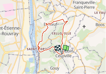
Trail Walking of 11.8 km to be discovered at Normandy, Seine-Maritime, Saint-Aubin-Celloville. This trail is proposed by MichelRando7656.
Description
Randonnée campagne et forêts Superbe panorama sur les hauteurs de Saint-Adrien.
2 longues côtes bien raides et une 3 eme pus courte pour terminer le circuit.
A éviter pendant la chasse.
Positioning
Country:
France
Region :
Normandy
Department/Province :
Seine-Maritime
Municipality :
Saint-Aubin-Celloville
Location:
Unknown
Start:(Dec)
Start:(UTM)
366152 ; 5469669 (31U) N.
Comments
Trails nearby
![Trail Walking Oissel - Oissel 13 km - Photo](https://media.geolcdn.com/t/375/260/ext.jpg?maxdim=2&url=https%3A%2F%2Fstatic1.geolcdn.com%2Fsiteimages%2Fupload%2Ffiles%2F1553511878bg_sport_marche.png)
![Walking Walking](https://static1.geolcdn.com/sitytour/trail-icons/101.png)
Oissel 13 km
Walking
Very easy
(1)
Oissel,
Normandy,
Seine-Maritime,
France
![](/images/other/stat-length.png)
13.3 km | 15.2 km-effort
2h 35min
![](https://static1.geolcdn.com/siteimages/upload/files/16400158638029165_repeat_loop_refresh_sync_direction_icon.png)
Yes
![Trail Walking Oissel - Oissel 13 km - Photo](https://media.geolcdn.com/t/375/260/ext.jpg?maxdim=2&url=https%3A%2F%2Fstatic1.geolcdn.com%2Fsiteimages%2Fupload%2Ffiles%2F1553511878bg_sport_marche.png)
![Walking Walking](https://static1.geolcdn.com/sitytour/trail-icons/101.png)
Oissel 13 km
Walking
Very easy
(1)
Oissel,
Normandy,
Seine-Maritime,
France
![](/images/other/stat-length.png)
14.9 km | 16.9 km-effort
2h 35min
![](https://static1.geolcdn.com/siteimages/upload/files/16400158638029165_repeat_loop_refresh_sync_direction_icon.png)
Yes
![Trail Walking Oissel - Oissel 13 km - Photo](https://media.geolcdn.com/t/375/260/ext.jpg?maxdim=2&url=https%3A%2F%2Fstatic1.geolcdn.com%2Fsiteimages%2Fupload%2Ffiles%2F1553511878bg_sport_marche.png)
![Walking Walking](https://static1.geolcdn.com/sitytour/trail-icons/101.png)
Oissel 13 km
Walking
Very easy
(1)
Oissel,
Normandy,
Seine-Maritime,
France
![](/images/other/stat-length.png)
13.6 km | 15.4 km-effort
2h 35min
![](https://static1.geolcdn.com/siteimages/upload/files/16400158638029165_repeat_loop_refresh_sync_direction_icon.png)
Yes
![Trail Walking Ymare - Ymare - Photo](https://media.geolcdn.com/t/375/260/ext.jpg?maxdim=2&url=https%3A%2F%2Fstatic1.geolcdn.com%2Fsiteimages%2Fupload%2Ffiles%2F1553511878bg_sport_marche.png)
![Walking Walking](https://static1.geolcdn.com/sitytour/trail-icons/101.png)
Ymare
Walking
Very easy
(1)
Ymare,
Normandy,
Seine-Maritime,
France
![](/images/other/stat-length.png)
8.9 km | 10.6 km-effort
2h 0min
![](https://static1.geolcdn.com/siteimages/upload/files/16400158638029165_repeat_loop_refresh_sync_direction_icon.png)
Yes
![Trail Walking Les Authieux-sur-le-Port-Saint-Ouen - *les Authieux Igoville 15km - Photo](https://media.geolcdn.com/t/375/260/acace470-e678-4207-9fe1-f083d26db0f1.jpg&format=jpg&maxdim=2)
![Walking Walking](https://static1.geolcdn.com/sitytour/trail-icons/101.png)
*les Authieux Igoville 15km
Walking
Very easy
(1)
Les Authieux-sur-le-Port-Saint-Ouen,
Normandy,
Seine-Maritime,
France
![](/images/other/stat-length.png)
13.9 km | 16.5 km-effort
3h 37min
![](https://static1.geolcdn.com/siteimages/upload/files/16400158638029165_repeat_loop_refresh_sync_direction_icon.png)
Yes
![Walking Walking](https://static1.geolcdn.com/sitytour/trail-icons/101.png)
20240305-Gouy
Walking
Medium
Les Authieux-sur-le-Port-Saint-Ouen,
Normandy,
Seine-Maritime,
France
![](/images/other/stat-length.png)
10.7 km | 13.1 km-effort
2h 35min
![](https://static1.geolcdn.com/siteimages/upload/files/16400158638029165_repeat_loop_refresh_sync_direction_icon.png)
Yes
![Trail Walking Sotteville-sous-le-Val - 20240206-Sotteville sous le Val - Photo](https://media.geolcdn.com/t/375/260/10e7cce0-0471-4b6b-b343-86046b8aac60.jpg&format=jpg&maxdim=2)
![Walking Walking](https://static1.geolcdn.com/sitytour/trail-icons/101.png)
20240206-Sotteville sous le Val
Walking
Medium
Sotteville-sous-le-Val,
Normandy,
Seine-Maritime,
France
![](/images/other/stat-length.png)
11.4 km | 13.5 km-effort
2h 34min
![](https://static1.geolcdn.com/siteimages/upload/files/16400158638029165_repeat_loop_refresh_sync_direction_icon.png)
Yes
![Trail Walking Quévreville-la-Poterie - 20240104-Quevreville la Potterie - Photo](https://media.geolcdn.com/t/375/260/0b8d8346-6b3b-4e80-8d5c-b85557b11606.jpg&format=jpg&maxdim=2)
![Walking Walking](https://static1.geolcdn.com/sitytour/trail-icons/101.png)
20240104-Quevreville la Potterie
Walking
Medium
Quévreville-la-Poterie,
Normandy,
Seine-Maritime,
France
![](/images/other/stat-length.png)
9.2 km | 11.2 km-effort
2h 43min
![](https://static1.geolcdn.com/siteimages/upload/files/16400158638029165_repeat_loop_refresh_sync_direction_icon.png)
Yes
![Trail Walking Quévreville-la-Poterie - 20231219-quevreville noel - Photo](https://media.geolcdn.com/t/375/260/9039af00-539b-4ef5-83fe-9bd657e6d749.jpg&format=jpg&maxdim=2)
![Walking Walking](https://static1.geolcdn.com/sitytour/trail-icons/101.png)
20231219-quevreville noel
Walking
Medium
Quévreville-la-Poterie,
Normandy,
Seine-Maritime,
France
![](/images/other/stat-length.png)
10.3 km | 12.6 km-effort
2h 55min
![](https://static1.geolcdn.com/siteimages/upload/files/16400158638029165_repeat_loop_refresh_sync_direction_icon.png)
Yes