![](/images/other/stat-length.png)
![Trail Mountain bike Davos - WallisBike 17 Davos - S-chanf - Photo](https://media.geolcdn.com/t/1900/400/ext.pjpeg?maxdim=2&url=https%3A%2F%2Fstatic1.geolcdn.com%2Fsiteimages%2Fupload%2Ffiles%2F1524743154velo.jpg)
WallisBike 17 Davos - S-chanf
ovronne
User
![Length](/images/other/stat-length.png)
Length
33 km
![Max alt](https://static1.geolcdn.com/siteimages/upload/files/1508320355ic_sort_altitude_max_24dp.png)
Max alt
2610 m
![Uphill gradient](https://static1.geolcdn.com/siteimages/upload/files/1508320355ic_sort_den_pos_24dp.png)
Uphill gradient
1168 m
![Km-Effort](/images/other/stat-length.png)
Km-Effort
48 km
![Min alt](https://static1.geolcdn.com/siteimages/upload/files/1508320355ic_sort_altitude_min_24dp.png)
Min alt
1538 m
![Downhill gradient](https://static1.geolcdn.com/siteimages/upload/files/1508320355ic_sort_den_neg_24dp.png)
Downhill gradient
1047 m
![Boucle](https://static1.geolcdn.com/siteimages/upload/files/16400158638029165_repeat_loop_refresh_sync_direction_icon.png)
Boucle
No
Creation date :
2014-12-11 00:00:00.0
Updated on :
2014-12-11 00:00:00.0
![Mountain bike](https://static1.geolcdn.com/sitytour/trail-icons/202.png)
2h35
Difficulty : Unknown
![Scan this QR Code to open this trail in the SityTrail application](https://capi.geolives.com/qq0zvz2zws4bq2lad0pu/sitytour/trails/25212/qr.png?size=200)
FREE GPS app for hiking
About
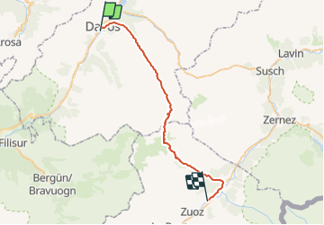
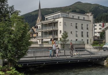
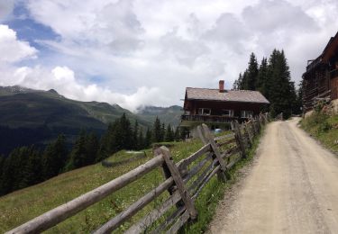
Trail Mountain bike of 33 km to be discovered at Grisons, Prättigau/Davos, Davos. This trail is proposed by ovronne.
Description
Dix-Septième étape de la traversée des Alpes Suisse de St-Gingolph à Scuol.
Départ de Davos, montée jusqu''à Scalettapass. Descente sur Alp Funtauna, Susauna et S-chanf.
Positioning
Country:
Switzerland
Region :
Grisons
Department/Province :
Prättigau/Davos
Municipality :
Davos
Location:
Unknown
Start:(Dec)
Start:(UTM)
562581 ; 5182289 (32T) N.
Comments
Trails nearby
![Trail On foot Davos - Jakobshorn - Ischalp - Photo](https://media.geolcdn.com/t/375/260/5423e66e-9ff1-4405-b076-091baecb842a.jpeg&format=jpg&maxdim=2)
![On foot On foot](https://static1.geolcdn.com/sitytour/trail-icons/100.png)
Jakobshorn - Ischalp
On foot
Easy
Davos,
Grisons,
Prättigau/Davos,
Switzerland
![](/images/other/stat-length.png)
4.5 km | 6.6 km-effort
1h 29min
![](https://static1.geolcdn.com/siteimages/upload/files/16400158638029165_repeat_loop_refresh_sync_direction_icon.png)
No
![Trail On foot Davos - CH-Jakobshorn - Tällifurgga - Photo](https://media.geolcdn.com/t/375/260/15954ad1-1045-406d-aa11-f10f7baae641.jpeg&format=jpg&maxdim=2)
![On foot On foot](https://static1.geolcdn.com/sitytour/trail-icons/100.png)
CH-Jakobshorn - Tällifurgga
On foot
Easy
Davos,
Grisons,
Prättigau/Davos,
Switzerland
![](/images/other/stat-length.png)
4 km | 6.5 km-effort
1h 28min
![](https://static1.geolcdn.com/siteimages/upload/files/16400158638029165_repeat_loop_refresh_sync_direction_icon.png)
No
![Trail On foot Davos - Hohe Promenade - Photo](https://media.geolcdn.com/t/375/260/df491f73-b254-41d3-a288-52806caf0e10.jpeg&format=jpg&maxdim=2)
![On foot On foot](https://static1.geolcdn.com/sitytour/trail-icons/100.png)
Hohe Promenade
On foot
Easy
Davos,
Grisons,
Prättigau/Davos,
Switzerland
![](/images/other/stat-length.png)
3.3 km | 4.5 km-effort
1h 1min
![](https://static1.geolcdn.com/siteimages/upload/files/16400158638029165_repeat_loop_refresh_sync_direction_icon.png)
No
![Trail On foot Davos - Davos - Clavadel - Photo](https://media.geolcdn.com/t/375/260/39101f0b-db86-4485-aff7-442f73303486.jpeg&format=jpg&maxdim=2)
![On foot On foot](https://static1.geolcdn.com/sitytour/trail-icons/100.png)
Davos - Clavadel
On foot
Easy
Davos,
Grisons,
Prättigau/Davos,
Switzerland
![](/images/other/stat-length.png)
3.4 km | 4.9 km-effort
1h 6min
![](https://static1.geolcdn.com/siteimages/upload/files/16400158638029165_repeat_loop_refresh_sync_direction_icon.png)
No
![Trail Walking Davos - wa16 - Photo](https://media.geolcdn.com/t/375/260/ext.jpg?maxdim=2&url=https%3A%2F%2Fstatic1.geolcdn.com%2Fsiteimages%2Fupload%2Ffiles%2F1553511878bg_sport_marche.png)
![Walking Walking](https://static1.geolcdn.com/sitytour/trail-icons/101.png)
wa16
Walking
Very easy
Davos,
Grisons,
Prättigau/Davos,
Switzerland
![](/images/other/stat-length.png)
8.7 km | 12.9 km-effort
Unknown
![](https://static1.geolcdn.com/siteimages/upload/files/16400158638029165_repeat_loop_refresh_sync_direction_icon.png)
No
![Trail Walking Davos - walser_23 - Photo](https://media.geolcdn.com/t/375/260/ext.jpg?maxdim=2&url=https%3A%2F%2Fstatic1.geolcdn.com%2Fsiteimages%2Fupload%2Ffiles%2F1553511878bg_sport_marche.png)
![Walking Walking](https://static1.geolcdn.com/sitytour/trail-icons/101.png)
walser_23
Walking
Very easy
Davos,
Grisons,
Prättigau/Davos,
Switzerland
![](/images/other/stat-length.png)
32 km | 56 km-effort
Unknown
![](https://static1.geolcdn.com/siteimages/upload/files/16400158638029165_repeat_loop_refresh_sync_direction_icon.png)
No
![Trail Mountain bike Davos - Clavadeler - Ischalp - Photo](https://media.geolcdn.com/t/375/260/ext.jpg?maxdim=2&url=https%3A%2F%2Fservices.sitytrail.com%2FGeolivesWS%2FDownloadMedia.ashx%3FTrailID%3D328948%26Media%3Db19fc973-a2e3-482c-946d-78230b20ebb4.JPG)
![Mountain bike Mountain bike](https://static1.geolcdn.com/sitytour/trail-icons/202.png)
Clavadeler - Ischalp
Mountain bike
Easy
Davos,
Grisons,
Prättigau/Davos,
Switzerland
![](/images/other/stat-length.png)
12.7 km | 20 km-effort
1h 15min
![](https://static1.geolcdn.com/siteimages/upload/files/16400158638029165_repeat_loop_refresh_sync_direction_icon.png)
Yes
![Trail Other activity Davos - Davos - Wolfgang - Laret - Photo](https://media.geolcdn.com/t/375/260/ext.jpg?maxdim=2&url=https%3A%2F%2Fstatic1.geolcdn.com%2Fsiteimages%2Fupload%2Ffiles%2F1545311037marcheuse_200dpi.jpg)
![Other activity Other activity](https://static1.geolcdn.com/sitytour/trail-icons/900.png)
Davos - Wolfgang - Laret
Other activity
Very easy
Davos,
Grisons,
Prättigau/Davos,
Switzerland
![](/images/other/stat-length.png)
4.1 km | 5.9 km-effort
Unknown
![](https://static1.geolcdn.com/siteimages/upload/files/16400158638029165_repeat_loop_refresh_sync_direction_icon.png)
No
![Trail Other activity Davos - Davos - Sertig-Talwanderung - Photo](https://media.geolcdn.com/t/375/260/ext.jpg?maxdim=2&url=https%3A%2F%2Fstatic1.geolcdn.com%2Fsiteimages%2Fupload%2Ffiles%2F1545311037marcheuse_200dpi.jpg)
![Other activity Other activity](https://static1.geolcdn.com/sitytour/trail-icons/900.png)
Davos - Sertig-Talwanderung
Other activity
Very easy
Davos,
Grisons,
Prättigau/Davos,
Switzerland
![](/images/other/stat-length.png)
6.7 km | 10.2 km-effort
Unknown
![](https://static1.geolcdn.com/siteimages/upload/files/16400158638029165_repeat_loop_refresh_sync_direction_icon.png)
No