Trail Walking Gemeinde Sölden - Autriche - Vent - Photo
© OpenStreetMap contributors
Length
Length
19.7 km
Max alt
Max alt
3004 m
Uphill gradient
Uphill gradient
629 m
Km-Effort
Km-Effort  
31 km
Min alt
Min alt
1877 m
Downhill gradient
Downhill gradient
1378 m
Boucle
Boucle
No
Creation date :
2020-08-19 08:10:40.0
Updated on :
2020-08-23 16:38:32.543

(0 Reviews)

Walking
Walking
8h41
Difficulty : Difficult

Scan this QR Code to open this trail in the SityTrail application

FREE GPS app for hiking

Logo SityTrail SityTrail

IGN / Geographical institutes

Download SityTrail from the App Store Download SityTrail from Google Play

Logo SityTrail SityTrail World

The world is yours!

Download SityTrail from the App Store Download SityTrail from Google Play Download SityTrail on Huawei AppGallery

About

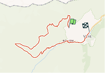
Trail Walking of 19.7 km to be discovered at Tyrol, Bezirk Imst, Gemeinde Sölden. This trail is proposed by nicolasbarbarin.

Description

Départ au-dessus des télésièges

Elevation profile

Positioning

Country:
Austria
Region :
Tyrol
Department/Province :
Bezirk Imst
Municipality :
Gemeinde Sölden
Location:
Unknown
Start:(UTM)
644267 ; 5192076 (32T) N.

Trails nearby

Trail On foot Gemeinde Sölden - Sonnberg-Höhenweg - Photo
On foot
GUIDE+

On foot

Easy
Gemeinde Sölden, Tyrol, Bezirk Imst, Austria
4.6 km | 7.2 km-effort
1h 38min
No
Trail Walking Gemeinde Sölden - Vent - Martin Busch Hutte - Photo
Walking
i20

Walking

Medium
Gemeinde Sölden, Tyrol, Bezirk Imst, Austria
17.3 km | 27 km-effort
4h 59min
Yes


Close
My subscriptions