![](/images/other/stat-length.png)
![Trail On foot Réallon - SityTrail - 145128 - aiguilles-de-chabrillaire - Photo](https://media.geolcdn.com/t/1900/400/ext.pjpeg?maxdim=2&url=https%3A%2F%2Fstatic1.geolcdn.com%2Fsiteimages%2Fupload%2Ffiles%2F1545311037marcheuse_200dpi.jpg)
SityTrail - 145128 - aiguilles-de-chabrillaire
pesce
User
![Length](/images/other/stat-length.png)
![Max alt](https://static1.geolcdn.com/siteimages/upload/files/1508320355ic_sort_altitude_max_24dp.png)
![Uphill gradient](https://static1.geolcdn.com/siteimages/upload/files/1508320355ic_sort_den_pos_24dp.png)
![Km-Effort](/images/other/stat-length.png)
![Min alt](https://static1.geolcdn.com/siteimages/upload/files/1508320355ic_sort_altitude_min_24dp.png)
![Downhill gradient](https://static1.geolcdn.com/siteimages/upload/files/1508320355ic_sort_den_neg_24dp.png)
![Boucle](https://static1.geolcdn.com/siteimages/upload/files/16400158638029165_repeat_loop_refresh_sync_direction_icon.png)
![On foot](https://static1.geolcdn.com/sitytour/trail-icons/100.png)
--
Difficulty : Unknown
![Scan this QR Code to open this trail in the SityTrail application](https://capi.geolives.com/qq0zvz2zws4bq2lad0pu/sitytour/trails/2517670/qr.png?size=200)
FREE GPS app for hiking
About
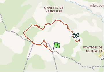
Trail On foot of 8.4 km to be discovered at Provence-Alpes-Côte d'Azur, Hautes-Alpes, Réallon. This trail is proposed by pesce.
Description
Parking de la station de realon . Prendre le télésiège jusqu à la table d'orientation et prendre le chemin à droite( bleu) vers la brèche. Montée raide et pierreuse mais vue fantastique qui récompense cet effort. Continuer le chemin après le col pour faire la crête avec vue vertigineuse sur le lac déserte pinçon et de tous les pics de la chaîne continuer le chemin( bleu) vers le retour 1er tronçon de télésiège .compter 2h30 après le passage de la brèche .rando magnifique avec vue et chemin très divers
Positioning
Comments
Trails nearby
![Trail Walking Réallon - AIguilles de Chabrieres au départ de la Station de ski Reallon - Photo](https://media.geolcdn.com/t/375/260/023f36e8-d4bb-4840-8d02-c81493ac1dcf.jpg&format=jpg&maxdim=2)
![Walking Walking](https://static1.geolcdn.com/sitytour/trail-icons/101.png)
Walking
![](/images/other/stat-length.png)
![](https://static1.geolcdn.com/siteimages/upload/files/16400158638029165_repeat_loop_refresh_sync_direction_icon.png)
![Trail Walking Réallon - Aiguilles de Chabrière - Photo](https://media.geolcdn.com/t/375/260/876aeb30-4d0c-470b-9156-901c8d05e3da.jpg&format=jpg&maxdim=2)
![Walking Walking](https://static1.geolcdn.com/sitytour/trail-icons/101.png)
Walking
![](/images/other/stat-length.png)
![](https://static1.geolcdn.com/siteimages/upload/files/16400158638029165_repeat_loop_refresh_sync_direction_icon.png)
![Trail Walking Réallon - le fort de Réallon - Photo](https://media.geolcdn.com/t/375/260/ext.jpg?maxdim=2&url=https%3A%2F%2Fservices.sitytrail.com%2FGeolivesWS%2FDownloadMedia.ashx%3FTrailID%3D731825%26Media%3Dfix__20170413090038.jpg)
![Walking Walking](https://static1.geolcdn.com/sitytour/trail-icons/101.png)
Walking
![](/images/other/stat-length.png)
![](https://static1.geolcdn.com/siteimages/upload/files/16400158638029165_repeat_loop_refresh_sync_direction_icon.png)
![Trail Walking Réallon - SityTrail - 2556786 - aiguilles-de-chabriere - Photo](https://media.geolcdn.com/t/375/260/ac3bac5b-f81d-4550-9055-615639b581a1.jpg&format=jpg&maxdim=2)
![Walking Walking](https://static1.geolcdn.com/sitytour/trail-icons/101.png)
Walking
![](/images/other/stat-length.png)
![](https://static1.geolcdn.com/siteimages/upload/files/16400158638029165_repeat_loop_refresh_sync_direction_icon.png)
![Trail Snowshoes Réallon - Raquettes Réallon - Photo](https://media.geolcdn.com/t/375/260/95a04571-4c6f-4065-a8af-914af77e268b.jpg&format=jpg&maxdim=2)
![Snowshoes Snowshoes](https://static1.geolcdn.com/sitytour/trail-icons/504.png)
Snowshoes
![](/images/other/stat-length.png)
![](https://static1.geolcdn.com/siteimages/upload/files/16400158638029165_repeat_loop_refresh_sync_direction_icon.png)
![Trail Walking Réallon - Reallon-Serre du Mouton 7km - Photo](https://media.geolcdn.com/t/375/260/9684f183-cb02-48c2-8699-e3c8ee97d988.jpg&format=jpg&maxdim=2)
![Walking Walking](https://static1.geolcdn.com/sitytour/trail-icons/101.png)
Walking
![](/images/other/stat-length.png)
![](https://static1.geolcdn.com/siteimages/upload/files/16400158638029165_repeat_loop_refresh_sync_direction_icon.png)
![Trail Walking Chorges - Les Parias et la Pousterle par le col de Chorges - Photo](https://media.geolcdn.com/t/375/260/8b1f1fa4-aaef-4c81-bd3d-65cfa8c4cbf8.jpg&format=jpg&maxdim=2)
![Walking Walking](https://static1.geolcdn.com/sitytour/trail-icons/101.png)
Walking
![](/images/other/stat-length.png)
![](https://static1.geolcdn.com/siteimages/upload/files/16400158638029165_repeat_loop_refresh_sync_direction_icon.png)
![Trail Walking Saint-Apollinaire - Aiguilles Chabrieres 08/08/18 - Photo](https://media.geolcdn.com/t/375/260/78ddfe44-69e9-44e6-832a-38dad99571c4.jpg&format=jpg&maxdim=2)
![Walking Walking](https://static1.geolcdn.com/sitytour/trail-icons/101.png)
Walking
![](/images/other/stat-length.png)
![](https://static1.geolcdn.com/siteimages/upload/files/16400158638029165_repeat_loop_refresh_sync_direction_icon.png)
![Trail Walking Réallon - Embrunais - Réallon Le Fort - 3.2km 200m 1h10 - 2018 06 28 - public - Photo](https://media.geolcdn.com/t/375/260/ext.jpg?maxdim=2&url=https%3A%2F%2Fservices.sitytrail.com%2FGeolivesWS%2FDownloadMedia.ashx%3FTrailID%3D999119%26Media%3Dfix__20180628151303.jpg)
![Walking Walking](https://static1.geolcdn.com/sitytour/trail-icons/101.png)
Walking
![](/images/other/stat-length.png)
![](https://static1.geolcdn.com/siteimages/upload/files/16400158638029165_repeat_loop_refresh_sync_direction_icon.png)