![](/images/other/stat-length.png)
![Trail Mountain bike Oron - Région Oron-la-Ville, parcours 4 - Photo](https://media.geolcdn.com/t/1900/400/ext.pjpeg?maxdim=2&url=https%3A%2F%2Fstatic1.geolcdn.com%2Fsiteimages%2Fupload%2Ffiles%2F1524743154velo.jpg)
Région Oron-la-Ville, parcours 4
Marginal
User
![Length](/images/other/stat-length.png)
Length
31 km
![Max alt](https://static1.geolcdn.com/siteimages/upload/files/1508320355ic_sort_altitude_max_24dp.png)
Max alt
875 m
![Uphill gradient](https://static1.geolcdn.com/siteimages/upload/files/1508320355ic_sort_den_pos_24dp.png)
Uphill gradient
732 m
![Km-Effort](/images/other/stat-length.png)
Km-Effort
41 km
![Min alt](https://static1.geolcdn.com/siteimages/upload/files/1508320355ic_sort_altitude_min_24dp.png)
Min alt
574 m
![Downhill gradient](https://static1.geolcdn.com/siteimages/upload/files/1508320355ic_sort_den_neg_24dp.png)
Downhill gradient
731 m
![Boucle](https://static1.geolcdn.com/siteimages/upload/files/16400158638029165_repeat_loop_refresh_sync_direction_icon.png)
Boucle
Yes
Creation date :
2014-12-11 00:00:00.0
Updated on :
2014-12-11 00:00:00.0
![Mountain bike](https://static1.geolcdn.com/sitytour/trail-icons/202.png)
--
Difficulty : Unknown
![Scan this QR Code to open this trail in the SityTrail application](https://capi.geolives.com/qq0zvz2zws4bq2lad0pu/sitytour/trails/25175/qr.png?size=200)
FREE GPS app for hiking
About
Trail Mountain bike of 31 km to be discovered at Vaud, District de Lavaux-Oron, Oron. This trail is proposed by Marginal.
Description
Randonnée VTT de 30km, en forêt et à découvert. Technique, roulant par endroits, à chaque détour d''un chemin c''est du plaisir.
Positioning
Country:
Switzerland
Region :
Vaud
Department/Province :
District de Lavaux-Oron
Municipality :
Oron
Location:
Unknown
Start:(Dec)
Start:(UTM)
332847 ; 5159797 (32T) N.
Comments
Trails nearby
![Trail Walking Saint-Martin (FR) - Sentier des arbres - St. Martin 20.09.15 - Photo](https://media.geolcdn.com/t/375/260/ext.jpg?maxdim=2&url=https%3A%2F%2Fservices.sitytrail.com%2FGeolivesWS%2FDownloadMedia.ashx%3FTrailID%3D473918%26Media%3D8cd9a2d7-6e5f-4e96-a34a-cd99341c4bc3.jpg)
![Walking Walking](https://static1.geolcdn.com/sitytour/trail-icons/101.png)
Sentier des arbres - St. Martin 20.09.15
Walking
Easy
Saint-Martin (FR),
Fribourg,
District de la Veveyse,
Switzerland
![](/images/other/stat-length.png)
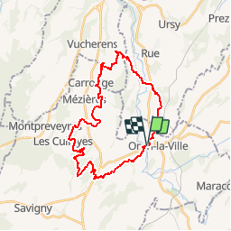
15.2 km | 20 km-effort
4h 42min
![](https://static1.geolcdn.com/siteimages/upload/files/16400158638029165_repeat_loop_refresh_sync_direction_icon.png)
Yes
![Trail Walking Jorat-Mézières - marche romande du général guisan - Photo](https://media.geolcdn.com/t/375/260/ext.jpg?maxdim=2&url=https%3A%2F%2Fstatic1.geolcdn.com%2Fsiteimages%2Fupload%2Ffiles%2F1553511878bg_sport_marche.png)
![Walking Walking](https://static1.geolcdn.com/sitytour/trail-icons/101.png)
marche romande du général guisan
Walking
Very easy
Jorat-Mézières,
Vaud,
District de Lavaux-Oron,
Switzerland
![](/images/other/stat-length.png)
28 km | 37 km-effort
Unknown
![](https://static1.geolcdn.com/siteimages/upload/files/16400158638029165_repeat_loop_refresh_sync_direction_icon.png)
Yes
![Trail Walking Rue - De Mossel à Dompierre - Photo](https://media.geolcdn.com/t/375/260/ext.jpg?maxdim=2&url=https%3A%2F%2Fstatic1.geolcdn.com%2Fsiteimages%2Fupload%2Ffiles%2F1553511878bg_sport_marche.png)
![Walking Walking](https://static1.geolcdn.com/sitytour/trail-icons/101.png)
De Mossel à Dompierre
Walking
Very easy
Rue,
Fribourg,
District de la Glâne,
Switzerland
![](/images/other/stat-length.png)
31 km | 40 km-effort
9h 49min
![](https://static1.geolcdn.com/siteimages/upload/files/16400158638029165_repeat_loop_refresh_sync_direction_icon.png)
No
![Trail Other activity Ecublens (FR) - Ecublens - Vauderens - Photo](https://media.geolcdn.com/t/375/260/ext.jpg?maxdim=2&url=https%3A%2F%2Fstatic1.geolcdn.com%2Fsiteimages%2Fupload%2Ffiles%2F1545311037marcheuse_200dpi.jpg)
![Other activity Other activity](https://static1.geolcdn.com/sitytour/trail-icons/900.png)
Ecublens - Vauderens
Other activity
Very easy
Ecublens (FR),
Fribourg,
District de la Glâne,
Switzerland
![](/images/other/stat-length.png)
6.5 km | 9.3 km-effort
Unknown
![](https://static1.geolcdn.com/siteimages/upload/files/16400158638029165_repeat_loop_refresh_sync_direction_icon.png)
No
![Trail Other activity Oron - Aux alentours du château d''Oron - Photo](https://media.geolcdn.com/t/375/260/ext.jpg?maxdim=2&url=https%3A%2F%2Fstatic1.geolcdn.com%2Fsiteimages%2Fupload%2Ffiles%2F1545311037marcheuse_200dpi.jpg)
![Other activity Other activity](https://static1.geolcdn.com/sitytour/trail-icons/900.png)
Aux alentours du château d''Oron
Other activity
Very easy
Oron,
Vaud,
District de Lavaux-Oron,
Switzerland
![](/images/other/stat-length.png)
11.6 km | 16.6 km-effort
Unknown
![](https://static1.geolcdn.com/siteimages/upload/files/16400158638029165_repeat_loop_refresh_sync_direction_icon.png)
No
![Trail Other activity Oron - Oron - Lausanne - Photo](https://media.geolcdn.com/t/375/260/ext.jpg?maxdim=2&url=https%3A%2F%2Fstatic1.geolcdn.com%2Fsiteimages%2Fupload%2Ffiles%2F1545311037marcheuse_200dpi.jpg)
![Other activity Other activity](https://static1.geolcdn.com/sitytour/trail-icons/900.png)
Oron - Lausanne
Other activity
Very easy
Oron,
Vaud,
District de Lavaux-Oron,
Switzerland
![](/images/other/stat-length.png)
26 km | 34 km-effort
5h 50min
![](https://static1.geolcdn.com/siteimages/upload/files/16400158638029165_repeat_loop_refresh_sync_direction_icon.png)
No
![Trail Road bike Vulliens - Le borgeau - Photo](https://media.geolcdn.com/t/375/260/ext.jpg?maxdim=2&url=https%3A%2F%2Fstatic1.geolcdn.com%2Fsiteimages%2Fupload%2Ffiles%2F1524743154velo.jpg)
![Road bike Road bike](https://static1.geolcdn.com/sitytour/trail-icons/201.png)
Le borgeau
Road bike
Easy
Vulliens,
Vaud,
District de la Broye-Vully,
Switzerland
![](/images/other/stat-length.png)
43 km | 53 km-effort
2h 28min
![](https://static1.geolcdn.com/siteimages/upload/files/16400158638029165_repeat_loop_refresh_sync_direction_icon.png)
Yes
![Trail Walking Jorat-Mézières - ferlens - Photo](https://media.geolcdn.com/t/375/260/ext.jpg?maxdim=2&url=https%3A%2F%2Fstatic1.geolcdn.com%2Fsiteimages%2Fupload%2Ffiles%2F1553511878bg_sport_marche.png)
![Walking Walking](https://static1.geolcdn.com/sitytour/trail-icons/101.png)
ferlens
Walking
Easy
Jorat-Mézières,
Vaud,
District de Lavaux-Oron,
Switzerland
![](/images/other/stat-length.png)
7.8 km | 10 km-effort
Unknown
![](https://static1.geolcdn.com/siteimages/upload/files/16400158638029165_repeat_loop_refresh_sync_direction_icon.png)
Yes
![Trail Other activity Oron - merde - Photo](https://media.geolcdn.com/t/375/260/ext.jpg?maxdim=2&url=https%3A%2F%2Fstatic1.geolcdn.com%2Fsiteimages%2Fupload%2Ffiles%2F1545311037marcheuse_200dpi.jpg)
![Other activity Other activity](https://static1.geolcdn.com/sitytour/trail-icons/900.png)
merde
Other activity
Very easy
Oron,
Vaud,
District de Lavaux-Oron,
Switzerland
![](/images/other/stat-length.png)
1969 km | 2938 km-effort
Unknown
![](https://static1.geolcdn.com/siteimages/upload/files/16400158638029165_repeat_loop_refresh_sync_direction_icon.png)
No