Trail Walking Saint-Arey - Le Senepy depart Prunieres - Photo

Le Senepy depart Prunieres

© OpenStreetMap contributors
Length
Length
12.4 km
Max alt
Max alt
1766 m
Uphill gradient
Uphill gradient
511 m
Km-Effort
Km-Effort  
21 km
Min alt
Min alt
679 m
Downhill gradient
Downhill gradient
1110 m
Boucle
Boucle
No
Creation date :
2020-08-15 07:22:27.489
Updated on :
2020-08-16 19:05:19.062

(0 Reviews)

Walking
Walking
4h32
Difficulty : Medium

Scan this QR Code to open this trail in the SityTrail application

FREE GPS app for hiking

Logo SityTrail SityTrail

IGN / Geographical institutes

Download SityTrail from the App Store Download SityTrail from Google Play

Logo SityTrail SityTrail World

The world is yours!

Download SityTrail from the App Store Download SityTrail from Google Play Download SityTrail on Huawei AppGallery

About

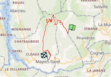
Trail Walking of 12.4 km to be discovered at Auvergne-Rhône-Alpes, Isère, Saint-Arey. This trail is proposed by claude nier.

Description

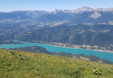
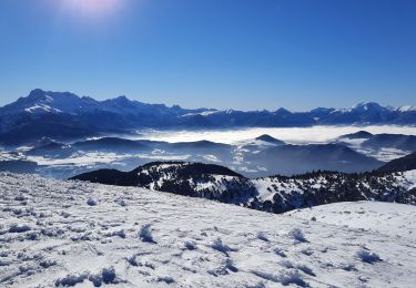
Depart Prunieres...Sommet du Senepy et descente par le Serre de l Aigle sur Mayres Savel..
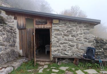
belle rando...pas de Loup ...dommage

Elevation profile

Positioning

Country:
France
Region :
Auvergne-Rhône-Alpes
Department/Province :
Isère
Municipality :
Saint-Arey
Location:
Unknown
Start:(UTM)
716719 ; 4975071 (31T) N.

Trails nearby

Trail Road bike La Mure - La Mure les 4 lacs - Photo
Road bike
Uio73

Road bike

Medium
(1)
La Mure, Auvergne-Rhône-Alpes, Isère, France
58 km | 72 km-effort
4h 22min
Yes
Trail Walking Mayres-Savel - Passerelles Hymalayene  Mayres + 250 - Photo
Walking
claude nier

Walking

Medium
Mayres-Savel, Auvergne-Rhône-Alpes, Isère, France
4.9 km | 8.2 km-effort
1h 59min
Yes
Trail Walking Susville - Susville les Merlins boucle par le col du Sénépiy - Photo
Walking
gmtrando

Walking

Medium
Susville, Auvergne-Rhône-Alpes, Isère, France
10.1 km | 16.3 km-effort
3h 30min
Yes
Trail Walking Mayres-Savel - Randonnée des passerelles  - Photo
Walking
choubaka77

Walking

Easy
Mayres-Savel, Auvergne-Rhône-Alpes, Isère, France
11.9 km | 17.9 km-effort
4h 51min
No
Trail Mountain bike La Motte-d'Aveillans - Le Sénépy depuis Les Signaraux - Photo
Mountain bike
patjobou

Mountain bike

Medium
La Motte-d'Aveillans, Auvergne-Rhône-Alpes, Isère, France
20 km | 32 km-effort
3h 39min
Yes
Trail Walking La Motte-d'Aveillans - Col du Sénépy et Pierre Plantée depuis les Signaraux - Photo
Walking
GuyVachet

Walking

Medium
La Motte-d'Aveillans, Auvergne-Rhône-Alpes, Isère, France
10.2 km | 15.8 km-effort
5h 39min
Yes
Trail Trail Prunières - Trail du 3ème Poste  - Photo
Trail
phd04

Trail

Medium
Prunières, Auvergne-Rhône-Alpes, Isère, France
17.7 km | 28 km-effort
2h 33min
No
Trail Walking La Motte-d'Aveillans - Les Signaraux - La Pierre Plantée  - Le Serre de L'Horizon - Le Col du Sénépy - Photo
Walking
patjobou

Walking

Easy
La Motte-d'Aveillans, Auvergne-Rhône-Alpes, Isère, France
8.7 km | 14.3 km-effort
2h 48min
Yes
Trail Walking Mayres-Savel - Passerelles  Du Drac Et de L'Ebron - Photo
Walking
donda

Walking

Easy
Mayres-Savel, Auvergne-Rhône-Alpes, Isère, France
12.2 km | 18.4 km-effort
3h 13min
No


Close
My subscriptions