Trail Walking Barles - BARLES Le Barri AR départ le Bas Moulin o l s  - Photo

BARLES Le Barri AR départ le Bas Moulin o l s

 RobinMicheline
RobinMicheline

User GUIDE

© OpenStreetMap contributors
Length
Length
12 km
Max alt
Max alt
1588 m
Uphill gradient
Uphill gradient
648 m
Km-Effort
Km-Effort  
21 km
Min alt
Min alt
954 m
Downhill gradient
Downhill gradient
648 m
Boucle
Boucle
Yes
Creation date :
2020-08-15 03:41:50.422
Updated on :
2020-08-15 15:47:24.759

(0 Reviews)

Walking
Walking
3h49
Difficulty : Medium

Scan this QR Code to open this trail in the SityTrail application

FREE GPS app for hiking

Logo SityTrail SityTrail

IGN / Geographical institutes

Download SityTrail from the App Store Download SityTrail from Google Play

Logo SityTrail SityTrail World

The world is yours!

Download SityTrail from the App Store Download SityTrail from Google Play Download SityTrail on Huawei AppGallery

About

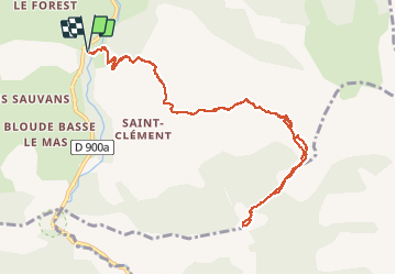
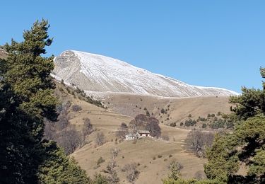
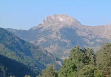
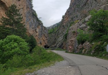
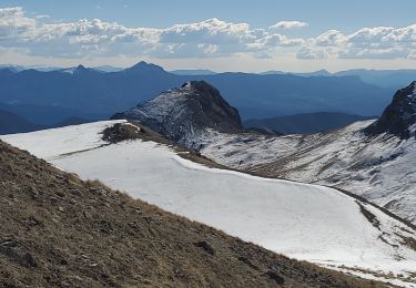
Trail Walking of 12 km to be discovered at Provence-Alpes-Côte d'Azur, Alpes-de-Haute-Provence, Barles. This trail is proposed by RobinMicheline.

Description

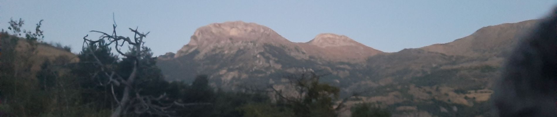
Agreable belle vue sur clues et Cloches

Elevation profile

Photos

Positioning

Country:
France
Region :
Provence-Alpes-Côte d'Azur
Department/Province :
Alpes-de-Haute-Provence
Municipality :
Barles
Location:
Unknown
Start:(UTM)
281335 ; 4903537 (32T) N.

Trails nearby

Trail Walking La Robine-sur-Galabre - LAMBERT mourre du barri - Photo
Walking
GUIDE
RobinMicheline

Walking

Very easy
(1)
La Robine-sur-Galabre, Provence-Alpes-Côte d'Azur, Alpes-de-Haute-Provence, France
12.6 km | 21 km-effort
4h 18min
Yes
Trail Walking La Robine-sur-Galabre - AINAC Col S Antoine . Feissal o s  - Photo
Walking
GUIDE
RobinMicheline

Walking

Medium
La Robine-sur-Galabre, Provence-Alpes-Côte d'Azur, Alpes-de-Haute-Provence, France
12.7 km | 19.3 km-effort
3h 47min
Yes
Trail Walking Barles - BARLES Vaux , col de Clapouse , la Laupie. boucle o - Photo
Walking
GUIDE
RobinMicheline

Walking

Very difficult
Barles, Provence-Alpes-Côte d'Azur, Alpes-de-Haute-Provence, France
11.7 km | 24 km-effort
4h 38min
Yes
Trail Walking Barles - Cloches de Barles - Photo
Walking
Nicomontagnes

Walking

Very easy
(2)
Barles, Provence-Alpes-Côte d'Azur, Alpes-de-Haute-Provence, France
11.1 km | 21 km-effort
2h 21min
Yes
Trail Walking Barles - Grande Cloche de Barles - Photo
Walking
motardes04

Walking

Easy
(1)
Barles, Provence-Alpes-Côte d'Azur, Alpes-de-Haute-Provence, France
11.2 km | 20 km-effort
3h 58min
Yes
Trail Walking Auzet - Auzet marzenc 993m 17kms  - Photo
Walking
GUIDE
Danielba

Walking

Medium
Auzet, Provence-Alpes-Côte d'Azur, Alpes-de-Haute-Provence, France
16.4 km | 28 km-effort
7h 23min
No
Trail Walking Barles - BARLES .TOUR DES CLUES DE VERDACHES O L  - Photo
Walking
GUIDE
RobinMicheline

Walking

Medium
Barles, Provence-Alpes-Côte d'Azur, Alpes-de-Haute-Provence, France
9 km | 14.3 km-effort
2h 59min
Yes
Trail Walking La Javie - vélodrome esclangon 17kms 1049m - Photo
Walking
GUIDE
Danielba

Walking

Difficult
La Javie, Provence-Alpes-Côte d'Azur, Alpes-de-Haute-Provence, France
15.5 km | 29 km-effort
7h 28min
Yes
Trail Walking Barles - Chine 14kms 875m - Photo
Walking
GUIDE
Danielba

Walking

Medium
Barles, Provence-Alpes-Côte d'Azur, Alpes-de-Haute-Provence, France
13.1 km | 24 km-effort
7h 23min
Yes


Close
My subscriptions