Trail Other activity Foum Zguid - J6-foum_ouled - Photo
 bikeup
bikeup

User

© OpenStreetMap contributors
Length
Length
248 km
Max alt
Max alt
1959 m
Uphill gradient
Uphill gradient
5141 m
Km-Effort
Km-Effort  
317 km
Min alt
Min alt
480 m
Downhill gradient
Downhill gradient
5306 m
Boucle
Boucle
No
Creation date :
2014-12-10 00:00:00.0
Updated on :
2014-12-10 00:00:00.0

(0 Reviews)

Other activity
Other activity
11h40
Difficulty : Unknown

Scan this QR Code to open this trail in the SityTrail application

FREE GPS app for hiking

Logo SityTrail SityTrail

IGN / Geographical institutes

Download SityTrail from the App Store Download SityTrail from Google Play

Logo SityTrail SityTrail World

The world is yours!

Download SityTrail from the App Store Download SityTrail from Google Play Download SityTrail on Huawei AppGallery

About

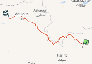
Trail Other activity of 248 km to be discovered at Souss-Massa, Pachalik de Foum Zguid, Foum Zguid. This trail is proposed by bikeup.

Elevation profile

Positioning

Country:
Morocco
Region :
Souss-Massa
Department/Province :
Pachalik de Foum Zguid
Municipality :
Foum Zguid
Location:
Unknown
Start:(UTM)
705133 ; 3329806 (29R) N.

Trails nearby

Trail 4x4 Foum Zguid - 18 fev Foum Suid Chegaga - Photo
4x4
michcoq

4x4

Very easy
Foum Zguid, Souss-Massa, Pachalik de Foum Zguid, Morocco
99 km | 107 km-effort
Unknown
No
Trail Car Foum Zguid - Désert 1 - Photo
Car
igueury

Car

Foum Zguid, Souss-Massa, Pachalik de Foum Zguid, Morocco
97 km | 105 km-effort
3h 7min
No


Close
My subscriptions