![](/images/other/stat-length.png)
![Trail Walking Thuès-Entre-Valls - boucle gorges carenca - Photo](https://media.geolcdn.com/t/1900/400/ext.pjpeg?maxdim=2&url=https%3A%2F%2Fstatic1.geolcdn.com%2Fsiteimages%2Fupload%2Ffiles%2F1553511878bg_sport_marche.png)
boucle gorges carenca
fab0202
User
![Length](/images/other/stat-length.png)
Length
9.2 km
![Max alt](https://static1.geolcdn.com/siteimages/upload/files/1508320355ic_sort_altitude_max_24dp.png)
Max alt
1173 m
![Uphill gradient](https://static1.geolcdn.com/siteimages/upload/files/1508320355ic_sort_den_pos_24dp.png)
Uphill gradient
745 m
![Km-Effort](/images/other/stat-length.png)
Km-Effort
19.1 km
![Min alt](https://static1.geolcdn.com/siteimages/upload/files/1508320355ic_sort_altitude_min_24dp.png)
Min alt
843 m
![Downhill gradient](https://static1.geolcdn.com/siteimages/upload/files/1508320355ic_sort_den_neg_24dp.png)
Downhill gradient
736 m
![Boucle](https://static1.geolcdn.com/siteimages/upload/files/16400158638029165_repeat_loop_refresh_sync_direction_icon.png)
Boucle
Yes
Creation date :
2020-08-14 06:56:05.361
Updated on :
2020-08-14 12:06:58.873
![Walking](https://static1.geolcdn.com/sitytour/trail-icons/101.png)
3h00
Difficulty : Medium
![Scan this QR Code to open this trail in the SityTrail application](https://capi.geolives.com/qq0zvz2zws4bq2lad0pu/sitytour/trails/2513486/qr.png?size=200)
FREE GPS app for hiking
About
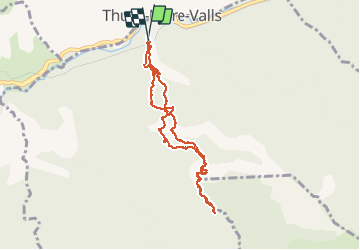
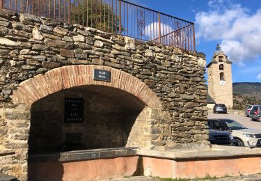
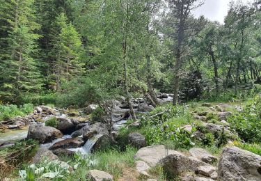
Trail Walking of 9.2 km to be discovered at Occitania, Pyrénées-Orientales, Thuès-Entre-Valls. This trail is proposed by fab0202.
Description
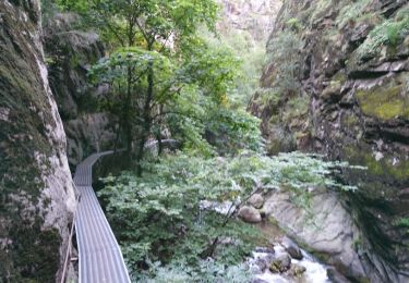
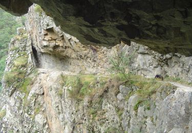
belle randonnée avec de superbes points de vue. Commencer par la montée du côté corniche. passage avec main courante sur la corniche et ensuite jusqu au pont de pierre, passage par des passerelles et pont de singe. La faire de bonne heure pour éviter le monde
Positioning
Country:
France
Region :
Occitania
Department/Province :
Pyrénées-Orientales
Municipality :
Thuès-Entre-Valls
Location:
Unknown
Start:(Dec)
Start:(UTM)
436053 ; 4708108 (31T) N.
Comments
Trails nearby
![Trail Walking Thuès-Entre-Valls - boucle des gorges de Caranca - Photo](https://media.geolcdn.com/t/375/260/ext.jpg?maxdim=2&url=https%3A%2F%2Fservices.sitytrail.com%2FGeolivesWS%2FDownloadMedia.ashx%3FTrailID%3D458010%26Media%3Dfix__20150803202132.jpg)
![Walking Walking](https://static1.geolcdn.com/sitytour/trail-icons/101.png)
boucle des gorges de Caranca
Walking
Medium
(2)
Thuès-Entre-Valls,
Occitania,
Pyrénées-Orientales,
France
![](/images/other/stat-length.png)
7.2 km | 15.3 km-effort
3h 1min
![](https://static1.geolcdn.com/siteimages/upload/files/16400158638029165_repeat_loop_refresh_sync_direction_icon.png)
Yes
![Trail Walking Thuès-Entre-Valls - Gorges de la garanca - Photo](https://media.geolcdn.com/t/375/260/ab886760-cfd8-4f4f-b5c8-9c9573fb7249.jpg&format=jpg&maxdim=2)
![Walking Walking](https://static1.geolcdn.com/sitytour/trail-icons/101.png)
Gorges de la garanca
Walking
Very easy
(1)
Thuès-Entre-Valls,
Occitania,
Pyrénées-Orientales,
France
![](/images/other/stat-length.png)
6.7 km | 13.1 km-effort
3h 39min
![](https://static1.geolcdn.com/siteimages/upload/files/16400158638029165_repeat_loop_refresh_sync_direction_icon.png)
No
![Trail Walking Fontpédrouse - Tour du Cucurucull - Photo](https://media.geolcdn.com/t/375/260/ext.jpg?maxdim=2&url=https%3A%2F%2Fservices.sitytrail.com%2FGeolivesWS%2FDownloadMedia.ashx%3FTrailID%3D376769%26Media%3Dfix__20150112140709.jpg)
![Walking Walking](https://static1.geolcdn.com/sitytour/trail-icons/101.png)
Tour du Cucurucull
Walking
Medium
(1)
Fontpédrouse,
Occitania,
Pyrénées-Orientales,
France
![](/images/other/stat-length.png)
9.3 km | 18.5 km-effort
3h 24min
![](https://static1.geolcdn.com/siteimages/upload/files/16400158638029165_repeat_loop_refresh_sync_direction_icon.png)
Yes
![Trail Walking Fontpédrouse - fontpérouse sentier des canaux et sources chaudes naturelles_T - Photo](https://media.geolcdn.com/t/375/260/ext.jpg?maxdim=2&url=https%3A%2F%2Fservices.sitytrail.com%2FGeolivesWS%2FDownloadMedia.ashx%3FTrailID%3D327463%26Media%3Dfix__20140724100812.jpg)
![Walking Walking](https://static1.geolcdn.com/sitytour/trail-icons/101.png)
fontpérouse sentier des canaux et sources chaudes naturelles_T
Walking
Medium
(1)
Fontpédrouse,
Occitania,
Pyrénées-Orientales,
France
![](/images/other/stat-length.png)
13.7 km | 25 km-effort
5h 9min
![](https://static1.geolcdn.com/siteimages/upload/files/16400158638029165_repeat_loop_refresh_sync_direction_icon.png)
Yes
![Trail Walking Thuès-Entre-Valls - Thuès-Entre-Valls - Gorges de la Cartança - 13.1km D 4h30mn (30mn) - 2018 09 11 - Photo](https://media.geolcdn.com/t/375/260/ext.jpg?maxdim=2&url=https%3A%2F%2Fservices.sitytrail.com%2FGeolivesWS%2FDownloadMedia.ashx%3FTrailID%3D1042072%26Media%3Dfix__20180911103923.jpg)
![Walking Walking](https://static1.geolcdn.com/sitytour/trail-icons/101.png)
Thuès-Entre-Valls - Gorges de la Cartança - 13.1km D 4h30mn (30mn) - 2018 09 11
Walking
Difficult
Thuès-Entre-Valls,
Occitania,
Pyrénées-Orientales,
France
![](/images/other/stat-length.png)
12.3 km | 23 km-effort
4h 30min
![](https://static1.geolcdn.com/siteimages/upload/files/16400158638029165_repeat_loop_refresh_sync_direction_icon.png)
Yes
![Trail Walking Thuès-Entre-Valls - Gorges de Carança - Photo](https://media.geolcdn.com/t/375/260/ext.jpg?maxdim=2&url=https%3A%2F%2Fstatic1.geolcdn.com%2Fsiteimages%2Fupload%2Ffiles%2F1553511878bg_sport_marche.png)
![Walking Walking](https://static1.geolcdn.com/sitytour/trail-icons/101.png)
Gorges de Carança
Walking
Medium
(2)
Thuès-Entre-Valls,
Occitania,
Pyrénées-Orientales,
France
![](/images/other/stat-length.png)
13.6 km | 30 km-effort
3h 43min
![](https://static1.geolcdn.com/siteimages/upload/files/16400158638029165_repeat_loop_refresh_sync_direction_icon.png)
Yes
![Trail Walking Canaveilles - 20221120 Canaveilles - Llar - Photo](https://media.geolcdn.com/t/375/260/027e0715-7eae-4325-8722-3c8908e90175.jpg&format=jpg&maxdim=2)
![Walking Walking](https://static1.geolcdn.com/sitytour/trail-icons/101.png)
20221120 Canaveilles - Llar
Walking
Medium
Canaveilles,
Occitania,
Pyrénées-Orientales,
France
![](/images/other/stat-length.png)
11 km | 20 km-effort
3h 15min
![](https://static1.geolcdn.com/siteimages/upload/files/16400158638029165_repeat_loop_refresh_sync_direction_icon.png)
Yes
![Trail Walking Thuès-Entre-Valls - Gorges de la Carança vers refuge - Photo](https://media.geolcdn.com/t/375/260/33d62a9a-e5f8-4c7e-95aa-95f744654ade.jpg&format=jpg&maxdim=2)
![Walking Walking](https://static1.geolcdn.com/sitytour/trail-icons/101.png)
Gorges de la Carança vers refuge
Walking
Medium
Thuès-Entre-Valls,
Occitania,
Pyrénées-Orientales,
France
![](/images/other/stat-length.png)
9.8 km | 22 km-effort
5h 33min
![](https://static1.geolcdn.com/siteimages/upload/files/16400158638029165_repeat_loop_refresh_sync_direction_icon.png)
No
![Trail On foot Thuès-Entre-Valls - Les Balcons de la Têt - Photo](https://media.geolcdn.com/t/375/260/0594e975-5a6f-4039-b448-6c6d79c6e324.jpeg&format=jpg&maxdim=2)
![On foot On foot](https://static1.geolcdn.com/sitytour/trail-icons/100.png)
Les Balcons de la Têt
On foot
Medium
Thuès-Entre-Valls,
Occitania,
Pyrénées-Orientales,
France
![](/images/other/stat-length.png)
10.9 km | 21 km-effort
4h 51min
![](https://static1.geolcdn.com/siteimages/upload/files/16400158638029165_repeat_loop_refresh_sync_direction_icon.png)
No