![](/images/other/stat-length.png)
![Trail On foot Chimay - La Fagne - Photo](https://media.geolcdn.com/t/1900/400/ext.pjpeg?maxdim=2&url=https%3A%2F%2Fstatic1.geolcdn.com%2Fsiteimages%2Fupload%2Ffiles%2F1545311037marcheuse_200dpi.jpg)
La Fagne
chanthan
User
![Length](/images/other/stat-length.png)
Length
6.2 km
![Max alt](https://static1.geolcdn.com/siteimages/upload/files/1508320355ic_sort_altitude_max_24dp.png)
Max alt
269 m
![Uphill gradient](https://static1.geolcdn.com/siteimages/upload/files/1508320355ic_sort_den_pos_24dp.png)
Uphill gradient
114 m
![Km-Effort](/images/other/stat-length.png)
Km-Effort
7.7 km
![Min alt](https://static1.geolcdn.com/siteimages/upload/files/1508320355ic_sort_altitude_min_24dp.png)
Min alt
218 m
![Downhill gradient](https://static1.geolcdn.com/siteimages/upload/files/1508320355ic_sort_den_neg_24dp.png)
Downhill gradient
114 m
![Boucle](https://static1.geolcdn.com/siteimages/upload/files/16400158638029165_repeat_loop_refresh_sync_direction_icon.png)
Boucle
Yes
Creation date :
2020-08-12 15:29:48.856
Updated on :
2020-08-12 15:37:09.095
![On foot](https://static1.geolcdn.com/sitytour/trail-icons/100.png)
--
Difficulty : Medium
![Scan this QR Code to open this trail in the SityTrail application](https://capi.geolives.com/qq0zvz2zws4bq2lad0pu/sitytour/trails/2511577/qr.png?size=200)
FREE GPS app for hiking
About
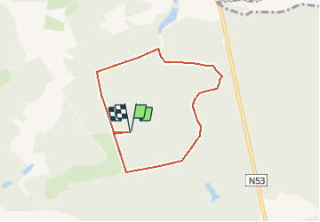
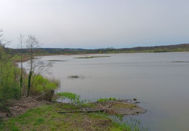
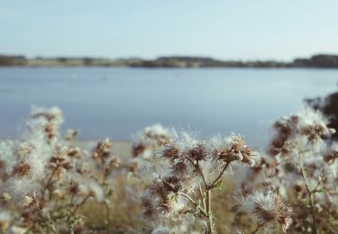
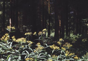
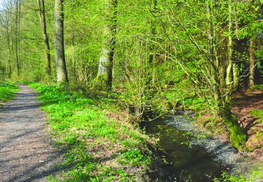
Trail On foot of 6.2 km to be discovered at Wallonia, Hainaut, Chimay. This trail is proposed by chanthan.
Description
Parcours dans les bois de la Fagne. Départ du parking du quai de chargement ( panneau Bois de Saint Georges), rue de la Fagne à Chimay. Coordonnées : N 50.1042 E 4.2652. Un peu vallonné mais bien aménagé. Moyen.
Positioning
Country:
Belgium
Region :
Wallonia
Department/Province :
Hainaut
Municipality :
Chimay
Location:
Chimay
Start:(Dec)
Start:(UTM)
590475 ; 5550983 (31U) N.
Comments
Trails nearby
![Trail Mountain bike Froidchapelle - Froidchapelle (7) - Mountain Bike Walk - Photo](https://media.geolcdn.com/t/375/260/ext.jpg?maxdim=2&url=https%3A%2F%2Fservices.sitytrail.com%2FGeolivesWS%2FDownloadMedia.ashx%3FTrailID%3D332241%26Media%3D0e28cef3-8d87-404e-aa4c-8e4248f5e1b1.JPG)
![Mountain bike Mountain bike](https://static1.geolcdn.com/sitytour/trail-icons/202.png)
Froidchapelle (7) - Mountain Bike Walk
Mountain bike
Medium
(4)
Froidchapelle,
Wallonia,
Hainaut,
Belgium
![](/images/other/stat-length.png)
32 km | 37 km-effort
2h 26min
![](https://static1.geolcdn.com/siteimages/upload/files/16400158638029165_repeat_loop_refresh_sync_direction_icon.png)
Yes
![Trail Walking Sivry-Rance - RB-HA-10 - Boucle champêtre autour de la Sambre - Photo](https://media.geolcdn.com/t/375/260/ext.jpg?maxdim=2&url=https%3A%2F%2Fservices.sitytrail.com%2FGeolivesWS%2FDownloadMedia.ashx%3FTrailID%3D219204%26Media%3De74974e9-21e7-4886-b770-97222bcdf8f4.jpg)
![Walking Walking](https://static1.geolcdn.com/sitytour/trail-icons/101.png)
RB-HA-10 - Boucle champêtre autour de la Sambre
Walking
Very difficult
(1)
Sivry-Rance,
Wallonia,
Hainaut,
Belgium
![](/images/other/stat-length.png)
21 km | 25 km-effort
5h 47min
![](https://static1.geolcdn.com/siteimages/upload/files/16400158638029165_repeat_loop_refresh_sync_direction_icon.png)
Yes
![Trail Walking Sivry-Rance - Sivry-Rance (13) - Vallée de l'Eau d'Eppe (Eppe Water Valley) Walk - Photo](https://media.geolcdn.com/t/375/260/ext.jpg?maxdim=2&url=https%3A%2F%2Fservices.sitytrail.com%2FGeolivesWS%2FDownloadMedia.ashx%3FTrailID%3D311163%26Media%3Db7af1830-b06f-43cc-9ab9-a464f12aaa86.JPG)
![Walking Walking](https://static1.geolcdn.com/sitytour/trail-icons/101.png)
Sivry-Rance (13) - Vallée de l'Eau d'Eppe (Eppe Water Valley) Walk
Walking
Very easy
(2)
Sivry-Rance,
Wallonia,
Hainaut,
Belgium
![](/images/other/stat-length.png)
6.6 km | 8.4 km-effort
2h 0min
![](https://static1.geolcdn.com/siteimages/upload/files/16400158638029165_repeat_loop_refresh_sync_direction_icon.png)
Yes
![Trail Walking Chimay - tour du lac de virelle - Photo](https://media.geolcdn.com/t/375/260/d9081fb4-98a0-4d7d-a262-a820b235ecb2.jpg&format=jpg&maxdim=2)
![Walking Walking](https://static1.geolcdn.com/sitytour/trail-icons/101.png)
tour du lac de virelle
Walking
Easy
Chimay,
Wallonia,
Hainaut,
Belgium
![](/images/other/stat-length.png)
10.6 km | 12.4 km-effort
3h 28min
![](https://static1.geolcdn.com/siteimages/upload/files/16400158638029165_repeat_loop_refresh_sync_direction_icon.png)
Yes
![Trail On foot Sivry-Rance - Promenade du Ry d'Hernoy - Photo](https://media.geolcdn.com/t/375/260/3576f0ab-5152-4ef1-90e0-3b37b935b6bd.jpeg&format=jpg&maxdim=2)
![On foot On foot](https://static1.geolcdn.com/sitytour/trail-icons/100.png)
Promenade du Ry d'Hernoy
On foot
Easy
Sivry-Rance,
Wallonia,
Hainaut,
Belgium
![](/images/other/stat-length.png)
9.8 km | 11.8 km-effort
2h 41min
![](https://static1.geolcdn.com/siteimages/upload/files/16400158638029165_repeat_loop_refresh_sync_direction_icon.png)
Yes
![Trail Mountain bike Froidchapelle - Promenade VTT - Froidchapelle - Photo](https://media.geolcdn.com/t/375/260/ext.jpg?maxdim=2&url=https%3A%2F%2Fpivotmedia.tourismewallonie.be%2FOTH-A0-004C-1TOP%2FOTH-A0-004C-1TOP.jpg)
![Mountain bike Mountain bike](https://static1.geolcdn.com/sitytour/trail-icons/202.png)
Promenade VTT - Froidchapelle
Mountain bike
Difficult
Froidchapelle,
Wallonia,
Hainaut,
Belgium
![](/images/other/stat-length.png)
32 km | 37 km-effort
2h 35min
![](https://static1.geolcdn.com/siteimages/upload/files/16400158638029165_repeat_loop_refresh_sync_direction_icon.png)
Yes
![Trail On foot Froidchapelle - Promenade d'Hernoy - chemin de fer - Photo](https://media.geolcdn.com/t/375/260/ext.jpg?maxdim=2&url=https%3A%2F%2Fpivotmedia.tourismewallonie.be%2FOTH-A0-004A-2ITM%2FOTH-A0-004A-2ITM.jpg)
![On foot On foot](https://static1.geolcdn.com/sitytour/trail-icons/100.png)
Promenade d'Hernoy - chemin de fer
On foot
Easy
Froidchapelle,
Wallonia,
Hainaut,
Belgium
![](/images/other/stat-length.png)
5.8 km | 6.8 km-effort
1h 32min
![](https://static1.geolcdn.com/siteimages/upload/files/16400158638029165_repeat_loop_refresh_sync_direction_icon.png)
Yes
![Trail On foot Sivry-Rance - Promenade du Ry d'Hernoy - Photo](https://media.geolcdn.com/t/375/260/ext.jpg?maxdim=2&url=https%3A%2F%2Fpivotmedia.tourismewallonie.be%2FOTH-A0-004C-34MC%2FOTH-A0-004C-34MC.jpg)
![On foot On foot](https://static1.geolcdn.com/sitytour/trail-icons/100.png)
Promenade du Ry d'Hernoy
On foot
Easy
(1)
Sivry-Rance,
Wallonia,
Hainaut,
Belgium
![](/images/other/stat-length.png)
9.7 km | 11.6 km-effort
2h 38min
![](https://static1.geolcdn.com/siteimages/upload/files/16400158638029165_repeat_loop_refresh_sync_direction_icon.png)
Yes
![Trail On foot Sivry-Rance - Promenade du Ry de Fromont - Photo](https://media.geolcdn.com/t/375/260/ext.jpg?maxdim=2&url=https%3A%2F%2Fpivotmedia.tourismewallonie.be%2FOTH-A0-004G-2A51%2FOTH-A0-004G-2A51.jpg)
![On foot On foot](https://static1.geolcdn.com/sitytour/trail-icons/100.png)
Promenade du Ry de Fromont
On foot
Easy
Sivry-Rance,
Wallonia,
Hainaut,
Belgium
![](/images/other/stat-length.png)
3.7 km | 4.6 km-effort
1h 3min
![](https://static1.geolcdn.com/siteimages/upload/files/16400158638029165_repeat_loop_refresh_sync_direction_icon.png)
Yes