![](/images/other/stat-length.png)
![Trail Cycle Maaseik - Fietslus Maaseik - Photo](https://media.geolcdn.com/t/1900/400/ext.pjpeg?maxdim=2&url=https%3A%2F%2Fstatic1.geolcdn.com%2Fsiteimages%2Fupload%2Ffiles%2F1524743154velo.jpg)
Fietslus Maaseik
zorro
User
![Length](/images/other/stat-length.png)
![Max alt](https://static1.geolcdn.com/siteimages/upload/files/1508320355ic_sort_altitude_max_24dp.png)
![Uphill gradient](https://static1.geolcdn.com/siteimages/upload/files/1508320355ic_sort_den_pos_24dp.png)
![Km-Effort](/images/other/stat-length.png)
![Min alt](https://static1.geolcdn.com/siteimages/upload/files/1508320355ic_sort_altitude_min_24dp.png)
![Downhill gradient](https://static1.geolcdn.com/siteimages/upload/files/1508320355ic_sort_den_neg_24dp.png)
![Boucle](https://static1.geolcdn.com/siteimages/upload/files/16400158638029165_repeat_loop_refresh_sync_direction_icon.png)
![Cycle](https://static1.geolcdn.com/sitytour/trail-icons/200.png)
1h47
Difficulty : Medium
![Scan this QR Code to open this trail in the SityTrail application](https://capi.geolives.com/qq0zvz2zws4bq2lad0pu/sitytour/trails/250801/qr.png?size=200)
FREE GPS app for hiking
About
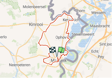
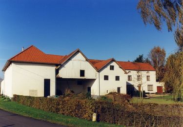
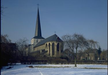
Trail Cycle of 28 km to be discovered at Flanders, Limburg, Maaseik. This trail is proposed by zorro.
Description
Maaseik is een uitstekende plaats om een verkenning van een stukje Maasland aan te vatten. Na je fietstocht wil je hier beslist een terrasje meepikken, maar de stad heeft ook een brede waaier aan bezienswaardigheden. De stadskern is niet zodanig groot, misschien heb je achteraf nog wel zin in een wandeling. Op het einde van deze fietsroute hebben we onze wandelroute in Maaseik bijgevoegd.
Positioning
Comments
Trails nearby
![Trail On foot Dilsen-Stokkem - Elen Gele zeshoek - Photo](https://media.geolcdn.com/t/375/260/7dae14a2-afe1-4f71-9fd2-720ade941e16.jpeg&format=jpg&maxdim=2)
![On foot On foot](https://static1.geolcdn.com/sitytour/trail-icons/100.png)
On foot
![](/images/other/stat-length.png)
![](https://static1.geolcdn.com/siteimages/upload/files/16400158638029165_repeat_loop_refresh_sync_direction_icon.png)
![Trail On foot Dilsen-Stokkem - Elen Oranje bol - Photo](https://media.geolcdn.com/t/375/260/571a30f3-6f71-44a5-99d0-17660bf69f28.jpeg&format=jpg&maxdim=2)
![On foot On foot](https://static1.geolcdn.com/sitytour/trail-icons/100.png)
On foot
![](/images/other/stat-length.png)
![](https://static1.geolcdn.com/siteimages/upload/files/16400158638029165_repeat_loop_refresh_sync_direction_icon.png)
![Trail On foot Dilsen-Stokkem - Elen Blauwe ruit - Photo](https://media.geolcdn.com/t/375/260/7dae14a2-afe1-4f71-9fd2-720ade941e16.jpeg&format=jpg&maxdim=2)
![On foot On foot](https://static1.geolcdn.com/sitytour/trail-icons/100.png)
On foot
![](/images/other/stat-length.png)
![](https://static1.geolcdn.com/siteimages/upload/files/16400158638029165_repeat_loop_refresh_sync_direction_icon.png)
![Trail On foot Dilsen-Stokkem - Elen Groene rechthoek - Photo](https://media.geolcdn.com/t/375/260/7dae14a2-afe1-4f71-9fd2-720ade941e16.jpeg&format=jpg&maxdim=2)
![On foot On foot](https://static1.geolcdn.com/sitytour/trail-icons/100.png)
On foot
![](/images/other/stat-length.png)
![](https://static1.geolcdn.com/siteimages/upload/files/16400158638029165_repeat_loop_refresh_sync_direction_icon.png)
![Trail On foot Maaseik - Tösch-Langeren Rode driehoek - Photo](https://media.geolcdn.com/t/375/260/9126700f-aede-4565-89c6-8d67eeb4d07b.jpeg&format=jpg&maxdim=2)
![On foot On foot](https://static1.geolcdn.com/sitytour/trail-icons/100.png)
On foot
![](/images/other/stat-length.png)
![](https://static1.geolcdn.com/siteimages/upload/files/16400158638029165_repeat_loop_refresh_sync_direction_icon.png)
![Trail On foot Maaseik - Tösch-Langeren Oranje bol - Photo](https://media.geolcdn.com/t/375/260/9126700f-aede-4565-89c6-8d67eeb4d07b.jpeg&format=jpg&maxdim=2)
![On foot On foot](https://static1.geolcdn.com/sitytour/trail-icons/100.png)
On foot
![](/images/other/stat-length.png)
![](https://static1.geolcdn.com/siteimages/upload/files/16400158638029165_repeat_loop_refresh_sync_direction_icon.png)
![Trail On foot Maaseik - Tösch-Langeren Blauwe ruit - Photo](https://media.geolcdn.com/t/375/260/85ce57bf-cef0-4d03-8455-4e3cc1ff99d1.jpeg&format=jpg&maxdim=2)
![On foot On foot](https://static1.geolcdn.com/sitytour/trail-icons/100.png)
On foot
![](/images/other/stat-length.png)
![](https://static1.geolcdn.com/siteimages/upload/files/16400158638029165_repeat_loop_refresh_sync_direction_icon.png)
![Trail On foot Maaseik - Tösch-Langeren Gele zeshoek - Photo](https://media.geolcdn.com/t/375/260/85ce57bf-cef0-4d03-8455-4e3cc1ff99d1.jpeg&format=jpg&maxdim=2)
![On foot On foot](https://static1.geolcdn.com/sitytour/trail-icons/100.png)
On foot
![](/images/other/stat-length.png)
![](https://static1.geolcdn.com/siteimages/upload/files/16400158638029165_repeat_loop_refresh_sync_direction_icon.png)
![Trail On foot Maaseik - Aldeneik & Maaseik Rode driehoek - Photo](https://media.geolcdn.com/t/375/260/4688143a-7d56-4795-b08e-4930e8771c1e.jpeg&format=jpg&maxdim=2)
![On foot On foot](https://static1.geolcdn.com/sitytour/trail-icons/100.png)
On foot
![](/images/other/stat-length.png)
![](https://static1.geolcdn.com/siteimages/upload/files/16400158638029165_repeat_loop_refresh_sync_direction_icon.png)