![](/images/other/stat-length.png)
![Trail Cycle Aarschot - Fietsen in de Demervallei rond Aarschot - Photo](https://media.geolcdn.com/t/1900/400/ext.pjpeg?maxdim=2&url=https%3A%2F%2Fstatic1.geolcdn.com%2Fsiteimages%2Fupload%2Ffiles%2F1524743154velo.jpg)
Fietsen in de Demervallei rond Aarschot
zorro
User
![Length](/images/other/stat-length.png)
![Max alt](https://static1.geolcdn.com/siteimages/upload/files/1508320355ic_sort_altitude_max_24dp.png)
![Uphill gradient](https://static1.geolcdn.com/siteimages/upload/files/1508320355ic_sort_den_pos_24dp.png)
![Km-Effort](/images/other/stat-length.png)
![Min alt](https://static1.geolcdn.com/siteimages/upload/files/1508320355ic_sort_altitude_min_24dp.png)
![Downhill gradient](https://static1.geolcdn.com/siteimages/upload/files/1508320355ic_sort_den_neg_24dp.png)
![Boucle](https://static1.geolcdn.com/siteimages/upload/files/16400158638029165_repeat_loop_refresh_sync_direction_icon.png)
![Cycle](https://static1.geolcdn.com/sitytour/trail-icons/200.png)
2h10
Difficulty : Medium
![Scan this QR Code to open this trail in the SityTrail application](https://capi.geolives.com/qq0zvz2zws4bq2lad0pu/sitytour/trails/250787/qr.png?size=200)
FREE GPS app for hiking
About
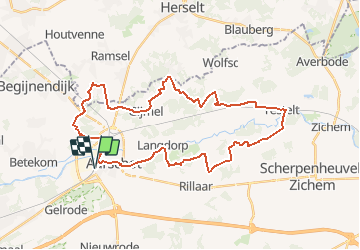
Trail Cycle of 34 km to be discovered at Flanders, Flemish Brabant, Aarschot. This trail is proposed by zorro.
Description
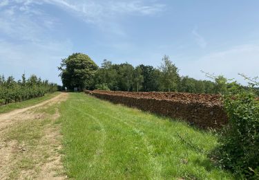
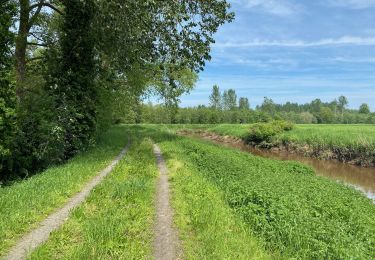
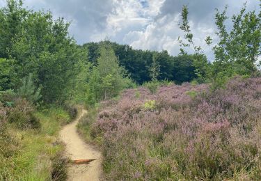
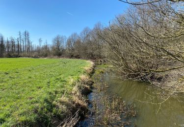
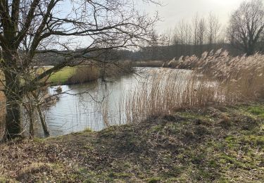
Het noordelijk gedeelte van het Hageland grenst aan de provincie Antwerpen. Het vormt de overgang van de Hagelandse ijzerzandsteenheuvels en de vlakke Kempen met zijn schrale heidegronden. Deze overgang zullen we op deze route duidelijk kunnen waarnemen: in het noordelijk gedeelte van de lus fietsen we o.a. door de Molenheide, een gebied met vennetjes en heidekruid. In het zuiden moeten we even op de trappers om de Wijngaardberg te beklimmen. Daartussenin loopt als een blauw lint de Demer.
Positioning
Comments
Trails nearby
![Trail On foot Aarschot - Kloesebos Rode driehoek - Photo](https://media.geolcdn.com/t/375/260/f4a0c03f-0ec6-441f-abfb-a6b5b510b476.jpeg&format=jpg&maxdim=2)
![On foot On foot](https://static1.geolcdn.com/sitytour/trail-icons/100.png)
On foot
![](/images/other/stat-length.png)
![](https://static1.geolcdn.com/siteimages/upload/files/16400158638029165_repeat_loop_refresh_sync_direction_icon.png)
![Trail On foot Aarschot - Kloesebos Blauwe ruit - Photo](https://media.geolcdn.com/t/375/260/66cc2f8c-dfb7-4bf1-9239-18bc78c78aaf.jpeg&format=jpg&maxdim=2)
![On foot On foot](https://static1.geolcdn.com/sitytour/trail-icons/100.png)
On foot
![](/images/other/stat-length.png)
![](https://static1.geolcdn.com/siteimages/upload/files/16400158638029165_repeat_loop_refresh_sync_direction_icon.png)
![Trail On foot Aarschot - Rillaarse Heuvelswandeling - Photo](https://media.geolcdn.com/t/375/260/2883ed0c-1972-44a3-9264-788ac17d3bac.jpeg&format=jpg&maxdim=2)
![On foot On foot](https://static1.geolcdn.com/sitytour/trail-icons/100.png)
On foot
![](/images/other/stat-length.png)
![](https://static1.geolcdn.com/siteimages/upload/files/16400158638029165_repeat_loop_refresh_sync_direction_icon.png)
![Trail Walking Begijnendijk - Betekom Arrschot Beemden Wandeling - 10 km RT - Photo](https://media.geolcdn.com/t/375/260/ext.jpg?maxdim=2&url=https%3A%2F%2Fstatic1.geolcdn.com%2Fsiteimages%2Fupload%2Ffiles%2F1553511878bg_sport_marche.png)
![Walking Walking](https://static1.geolcdn.com/sitytour/trail-icons/101.png)
Walking
![](/images/other/stat-length.png)
![](https://static1.geolcdn.com/siteimages/upload/files/16400158638029165_repeat_loop_refresh_sync_direction_icon.png)
![Trail Walking Aarschot - S-GR Hageland: Aarschot - Kortrijk-Dutsel - Photo](https://media.geolcdn.com/t/375/260/daa61efd-734b-467a-883e-c0aeca7e1e57.jpeg&format=jpg&maxdim=2)
![Walking Walking](https://static1.geolcdn.com/sitytour/trail-icons/101.png)
Walking
![](/images/other/stat-length.png)
![](https://static1.geolcdn.com/siteimages/upload/files/16400158638029165_repeat_loop_refresh_sync_direction_icon.png)
![Trail Walking Aarschot - Le long du Démer de Langdorp à Testelt - Photo](https://media.geolcdn.com/t/375/260/3ef3860a-670d-485e-846a-14ba86eef2f3.jpeg&format=jpg&maxdim=2)
![Walking Walking](https://static1.geolcdn.com/sitytour/trail-icons/101.png)
Walking
![](/images/other/stat-length.png)
![](https://static1.geolcdn.com/siteimages/upload/files/16400158638029165_repeat_loop_refresh_sync_direction_icon.png)
![Trail Walking Aarschot - SGR Hageland: de Aarschot à Wezemaal - Photo](https://media.geolcdn.com/t/375/260/589e36b9-24cd-45ab-b0f3-7629f63764a9.jpeg&format=jpg&maxdim=2)
![Walking Walking](https://static1.geolcdn.com/sitytour/trail-icons/101.png)
Walking
![](/images/other/stat-length.png)
![](https://static1.geolcdn.com/siteimages/upload/files/16400158638029165_repeat_loop_refresh_sync_direction_icon.png)
![Trail Walking Aarschot - Gelrode 14,7 km - Photo](https://media.geolcdn.com/t/375/260/82b7f051-104b-40d6-8589-4a41f1c67f17.jpg&format=jpg&maxdim=2)
![Walking Walking](https://static1.geolcdn.com/sitytour/trail-icons/101.png)
Walking
![](/images/other/stat-length.png)
![](https://static1.geolcdn.com/siteimages/upload/files/16400158638029165_repeat_loop_refresh_sync_direction_icon.png)
![Trail Walking Aarschot - Aarschot 20,5 km - Photo](https://media.geolcdn.com/t/375/260/70b55967-6233-4d74-905b-dcc126469651.jpg&format=jpg&maxdim=2)
![Walking Walking](https://static1.geolcdn.com/sitytour/trail-icons/101.png)
Walking
![](/images/other/stat-length.png)
![](https://static1.geolcdn.com/siteimages/upload/files/16400158638029165_repeat_loop_refresh_sync_direction_icon.png)