Trail Walking Riedisheim - randogps68-193 - Photo
 E.BURCK
E.BURCK

User

© OpenStreetMap contributors
Length
Length
10 km
Max alt
Max alt
370 m
Uphill gradient
Uphill gradient
211 m
Km-Effort
Km-Effort  
12.8 km
Min alt
Min alt
253 m
Downhill gradient
Downhill gradient
211 m
Boucle
Boucle
Yes
Creation date :
2020-08-08 15:58:27.356
Updated on :
2022-08-21 07:53:52.599

(0 Reviews)

Walking
Walking
2h27
Difficulty : Easy

Scan this QR Code to open this trail in the SityTrail application

FREE GPS app for hiking

Logo SityTrail SityTrail

IGN / Geographical institutes

Download SityTrail from the App Store Download SityTrail from Google Play

Logo SityTrail SityTrail World

The world is yours!

Download SityTrail from the App Store Download SityTrail from Google Play Download SityTrail on Huawei AppGallery

About

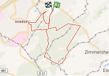
Trail Walking of 10 km to be discovered at Grand Est, Haut-Rhin, Riedisheim. This trail is proposed by E.BURCK.

Description

Départ randonnée :
Parking centre sportif du Waldeck, 68400 Riedisheim (Haut-Rhin)
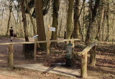
Un agréable et facile circuit en boucle de 9 km à travers le Tannenwald,
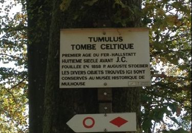
passant successivement au Tumulus, à la Vue des Alpes, au carrefour du Rotlaub,
à proximité de la tour relais Télécom et du zoo de Mulhouse.
Du parking, suivre la route et le balisage triangle rouge vers le sud sur 500 m,
virer à gauche et prendre le sentier balisé cercle rouge.
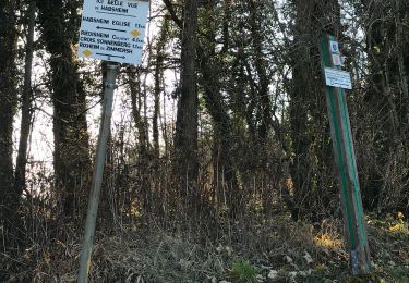
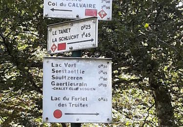
Suivre l’excellent balisage cercle rouge sur tout le circuit.
A la fin du circuit du cercle rouge, prendre à gauche pour revenir au parking du centre sportif du Waldeck.
Le circuit peut également se faire à partir de l’entrée du zoo de Mulhouse.
Carte IGN 3720 ET Mulhouse
extrait de https://www.randogps.net/

Elevation profile

Positioning

Country:
France
Region :
Grand Est
Department/Province :
Haut-Rhin
Municipality :
Riedisheim
Location:
Unknown
Start:(UTM)
377168 ; 5288230 (32T) N.

Trails nearby

Trail Walking Mulhouse - 20230904 - Mulhouse - Visite  - Photo
Walking
GUIDE
pierreh01

Walking

Easy
(1)
Mulhouse, Grand Est, Haut-Rhin, France
4.2 km | 4.6 km-effort
1h 23min
Yes
Trail On foot Mulhouse - Anneau rouge - Photo
On foot
GUIDE+

On foot

Easy
Mulhouse, Grand Est, Haut-Rhin, France
7.4 km | 9.7 km-effort
2h 11min
Yes
Trail Walking Riedisheim - Mulhouse / Ferrette..02/05/2024..les Marcheurs - Photo
Walking
boubou68

Walking

Very difficult
Riedisheim, Grand Est, Haut-Rhin, France
37 km | 48 km-effort
4h 9min
No
Trail Walking Riedisheim - circuit circulaire du Rothlaub - Photo
Walking
selevrich

Walking

Very easy
Riedisheim, Grand Est, Haut-Rhin, France
8.3 km | 10.7 km-effort
1h 45min
Yes
Trail Other activity Rixheim - promenade champêtre - Photo
Other activity
bemurix

Other activity

Very easy
Rixheim, Grand Est, Haut-Rhin, France
6.4 km | 8 km-effort
1h 50min
Yes
Trail Other activity Mulhouse - Grand Est - Ligne 4 - Paris Mulhouse (section de :Montreux-Vieux à Mulhouse) - Photo
Other activity
mich54

Other activity

Very easy
Mulhouse, Grand Est, Haut-Rhin, France
36 km | 39 km-effort
5min
No
Trail Walking Rixheim - JD 17/20 Collines de Habsheim - Photo
Walking
argonneuweg

Walking

Rixheim, Grand Est, Haut-Rhin, France
7.7 km | 9.7 km-effort
2h 0min
Yes
Trail Cycle Mulhouse - waldeck - Photo
Cycle
olivier5960

Cycle

Very easy
Mulhouse, Grand Est, Haut-Rhin, France
12.2 km | 16.1 km-effort
1h 12min
No
Trail Walking Mulhouse -
Walking
boubou68

Walking

Easy
Mulhouse, Grand Est, Haut-Rhin, France
3.1 km | 3.7 km-effort
50min
Yes


Close
My subscriptions