![](/images/other/stat-length.png)
![Trail Walking Waimes - Longfaye - Balade 11 - Guide de l'Ardenne du Nord - Photo](https://media.geolcdn.com/t/1900/400/ext.pjpeg?maxdim=2&url=https%3A%2F%2Fstatic1.geolcdn.com%2Fsiteimages%2Fupload%2Ffiles%2F1553511878bg_sport_marche.png)
Longfaye - Balade 11 - Guide de l'Ardenne du Nord
AnneCecile
User
![Length](/images/other/stat-length.png)
Length
8.7 km
![Max alt](https://static1.geolcdn.com/siteimages/upload/files/1508320355ic_sort_altitude_max_24dp.png)
Max alt
612 m
![Uphill gradient](https://static1.geolcdn.com/siteimages/upload/files/1508320355ic_sort_den_pos_24dp.png)
Uphill gradient
200 m
![Km-Effort](/images/other/stat-length.png)
Km-Effort
11.3 km
![Min alt](https://static1.geolcdn.com/siteimages/upload/files/1508320355ic_sort_altitude_min_24dp.png)
Min alt
440 m
![Downhill gradient](https://static1.geolcdn.com/siteimages/upload/files/1508320355ic_sort_den_neg_24dp.png)
Downhill gradient
206 m
![Boucle](https://static1.geolcdn.com/siteimages/upload/files/16400158638029165_repeat_loop_refresh_sync_direction_icon.png)
Boucle
Yes
Creation date :
2020-08-08 11:18:20.24
Updated on :
2020-08-08 11:33:16.434
![Walking](https://static1.geolcdn.com/sitytour/trail-icons/101.png)
2h46
Difficulty : Difficult
![Scan this QR Code to open this trail in the SityTrail application](https://capi.geolives.com/qq0zvz2zws4bq2lad0pu/sitytour/trails/2506615/qr.png?size=200)
FREE GPS app for hiking
About
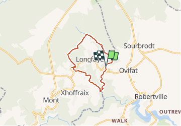
Trail Walking of 8.7 km to be discovered at Wallonia, Liège, Waimes. This trail is proposed by AnneCecile.
Description
Départ Moulin du Bayehon. Panneaux touristique au départ de la balade.
Balisage rectangle vert.
Parking à hauteur de l'épingle à cheveux de la route du Bayehon 64 4960 Malmedy
Positioning
Country:
Belgium
Region :
Wallonia
Department/Province :
Liège
Municipality :
Waimes
Location:
Robertville
Start:(Dec)
Start:(UTM)
293630 ; 5594711 (32U) N.
Comments
Trails nearby
![Trail Walking Waimes - RB-Lg-32_Botrange_via-racc-2 - Photo](https://media.geolcdn.com/t/375/260/ext.jpg?maxdim=2&url=https%3A%2F%2Fservices.sitytrail.com%2FGeolivesWS%2FDownloadMedia.ashx%3FTrailID%3D402164%26Media%3D5ad16311-48f2-4779-8b73-f8bce456ef00.jpg)
![Walking Walking](https://static1.geolcdn.com/sitytour/trail-icons/101.png)
RB-Lg-32_Botrange_via-racc-2
Walking
(6)
Waimes,
Wallonia,
Liège,
Belgium
![](/images/other/stat-length.png)
16.7 km | 22 km-effort
5h 4min
![](https://static1.geolcdn.com/siteimages/upload/files/16400158638029165_repeat_loop_refresh_sync_direction_icon.png)
Yes
![Trail Walking Waimes - RB-Lg-32_Botrange_via-racc-1 - Photo](https://media.geolcdn.com/t/375/260/ext.jpg?maxdim=2&url=https%3A%2F%2Fservices.sitytrail.com%2FGeolivesWS%2FDownloadMedia.ashx%3FTrailID%3D402158%26Media%3D5ad16311-48f2-4779-8b73-f8bce456ef00.jpg)
![Walking Walking](https://static1.geolcdn.com/sitytour/trail-icons/101.png)
RB-Lg-32_Botrange_via-racc-1
Walking
(7)
Waimes,
Wallonia,
Liège,
Belgium
![](/images/other/stat-length.png)
12.3 km | 15.7 km-effort
3h 34min
![](https://static1.geolcdn.com/siteimages/upload/files/16400158638029165_repeat_loop_refresh_sync_direction_icon.png)
Yes
![Trail Walking Waimes - RB-Lg-32_Botrange - Photo](https://media.geolcdn.com/t/375/260/ext.jpg?maxdim=2&url=https%3A%2F%2Fservices.sitytrail.com%2FGeolivesWS%2FDownloadMedia.ashx%3FTrailID%3D402156%26Media%3Dfd59a9ea-7261-4ddd-8af9-0290eaea98e9.jpg)
![Walking Walking](https://static1.geolcdn.com/sitytour/trail-icons/101.png)
![Trail Walking Malmedy - RB-Lg-31_Malmedy - Photo](https://media.geolcdn.com/t/375/260/ext.jpg?maxdim=2&url=https%3A%2F%2Fservices.sitytrail.com%2FGeolivesWS%2FDownloadMedia.ashx%3FTrailID%3D402114%26Media%3D216d2e53-3b66-4632-8b4d-0cea30889665.jpg)
![Walking Walking](https://static1.geolcdn.com/sitytour/trail-icons/101.png)
![Trail Walking Waimes - Sourbrodt - Circuit Natura 2000, des sites qui valent le détour - Lg11 - Photo](https://media.geolcdn.com/t/375/260/ext.jpg?maxdim=2&url=https%3A%2F%2Fservices.sitytrail.com%2FGeolivesWS%2FDownloadMedia.ashx%3FTrailID%3D181919%26Media%3Dc17de19f-5f6c-4ae3-b0c2-a0399f656a6f.jpg)
![Walking Walking](https://static1.geolcdn.com/sitytour/trail-icons/101.png)
Sourbrodt - Circuit Natura 2000, des sites qui valent le détour - Lg11
Walking
Easy
(9)
Waimes,
Wallonia,
Liège,
Belgium
![](/images/other/stat-length.png)
7.3 km | 8.3 km-effort
1h 50min
![](https://static1.geolcdn.com/siteimages/upload/files/16400158638029165_repeat_loop_refresh_sync_direction_icon.png)
Yes
![Trail Walking Malmedy - Le trôs Maret - Photo](https://media.geolcdn.com/t/375/260/97b4be7b-87c1-46c9-b673-d6e164fd84f1.jpg&format=jpg&maxdim=2)
![Walking Walking](https://static1.geolcdn.com/sitytour/trail-icons/101.png)
Le trôs Maret
Walking
Medium
(14)
Malmedy,
Wallonia,
Liège,
Belgium
![](/images/other/stat-length.png)
7.3 km | 10.1 km-effort
2h 11min
![](https://static1.geolcdn.com/siteimages/upload/files/16400158638029165_repeat_loop_refresh_sync_direction_icon.png)
Yes
![Trail Walking Waimes - Balade Peak Myrtille avec extension - restaurée - Photo](https://media.geolcdn.com/t/375/260/ext.jpg?maxdim=2&url=https%3A%2F%2Fstatic1.geolcdn.com%2Fsiteimages%2Fupload%2Ffiles%2F1553511878bg_sport_marche.png)
![Walking Walking](https://static1.geolcdn.com/sitytour/trail-icons/101.png)
Balade Peak Myrtille avec extension - restaurée
Walking
Medium
(43)
Waimes,
Wallonia,
Liège,
Belgium
![](/images/other/stat-length.png)
4.9 km | 6 km-effort
1h 22min
![](https://static1.geolcdn.com/siteimages/upload/files/16400158638029165_repeat_loop_refresh_sync_direction_icon.png)
Yes
![Trail Walking Waimes - Balade Peak Myrtille - restaurée - Photo](https://media.geolcdn.com/t/375/260/ext.jpg?maxdim=2&url=https%3A%2F%2Fstatic1.geolcdn.com%2Fsiteimages%2Fupload%2Ffiles%2F1553511878bg_sport_marche.png)
![Walking Walking](https://static1.geolcdn.com/sitytour/trail-icons/101.png)
Balade Peak Myrtille - restaurée
Walking
Easy
(20)
Waimes,
Wallonia,
Liège,
Belgium
![](/images/other/stat-length.png)
2.7 km | 3.3 km-effort
45min
![](https://static1.geolcdn.com/siteimages/upload/files/16400158638029165_repeat_loop_refresh_sync_direction_icon.png)
Yes
![Trail Walking Malmedy - La petite vallée sauvage du Trôs Marets - Photo](https://media.geolcdn.com/t/375/260/ext.jpg?maxdim=2&url=https%3A%2F%2Fstatic1.geolcdn.com%2Fsiteimages%2Fupload%2Ffiles%2F1553511878bg_sport_marche.png)
![Walking Walking](https://static1.geolcdn.com/sitytour/trail-icons/101.png)
La petite vallée sauvage du Trôs Marets
Walking
Medium
(8)
Malmedy,
Wallonia,
Liège,
Belgium
![](/images/other/stat-length.png)
9.1 km | 12 km-effort
2h 37min
![](https://static1.geolcdn.com/siteimages/upload/files/16400158638029165_repeat_loop_refresh_sync_direction_icon.png)
Yes