![](/images/other/stat-length.png)
![Trail Walking Martagny - Martagny, le Val d'érable 8.1 km - Photo](https://media.geolcdn.com/t/1900/400/ext.pjpeg?maxdim=2&url=https%3A%2F%2Fstatic1.geolcdn.com%2Fsiteimages%2Fupload%2Ffiles%2F1553511878bg_sport_marche.png)
Martagny, le Val d'érable 8.1 km
Marie-Claire-mcp
User
![Length](/images/other/stat-length.png)
Length
8.1 km
![Max alt](https://static1.geolcdn.com/siteimages/upload/files/1508320355ic_sort_altitude_max_24dp.png)
Max alt
195 m
![Uphill gradient](https://static1.geolcdn.com/siteimages/upload/files/1508320355ic_sort_den_pos_24dp.png)
Uphill gradient
156 m
![Km-Effort](/images/other/stat-length.png)
Km-Effort
10.1 km
![Min alt](https://static1.geolcdn.com/siteimages/upload/files/1508320355ic_sort_altitude_min_24dp.png)
Min alt
101 m
![Downhill gradient](https://static1.geolcdn.com/siteimages/upload/files/1508320355ic_sort_den_neg_24dp.png)
Downhill gradient
155 m
![Boucle](https://static1.geolcdn.com/siteimages/upload/files/16400158638029165_repeat_loop_refresh_sync_direction_icon.png)
Boucle
Yes
Creation date :
2020-08-07 09:38:55.007
Updated on :
2020-08-07 09:49:31.199
![Walking](https://static1.geolcdn.com/sitytour/trail-icons/101.png)
2h11
Difficulty : Medium
![Scan this QR Code to open this trail in the SityTrail application](https://capi.geolives.com/qq0zvz2zws4bq2lad0pu/sitytour/trails/2505488/qr.png?size=200)
FREE GPS app for hiking
About
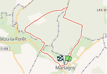
Trail Walking of 8.1 km to be discovered at Normandy, Eure, Martagny. This trail is proposed by Marie-Claire-mcp.
Description
Départ Parking devant l'ancienne école, prendre la route direction Bézu la Forêtjusque Viseneuil, tourner à droite dans le boid puis à gauche jusqu'au haut pontu puis à droite jusqu'au pavillon ...
Positioning
Country:
France
Region :
Normandy
Department/Province :
Eure
Municipality :
Martagny
Location:
Unknown
Start:(Dec)
Start:(UTM)
402638 ; 5472334 (31U) N.
Comments
Trails nearby
![Trail Walking Martagny - Martagny, forêt domaniale de Lyons et le monument de la Rougemare - Photo](https://media.geolcdn.com/t/375/260/8a602ec9-d0ca-42f6-b8dd-595ff5f1acc5.jpg&format=jpg&maxdim=2)
![Walking Walking](https://static1.geolcdn.com/sitytour/trail-icons/101.png)
Martagny, forêt domaniale de Lyons et le monument de la Rougemare
Walking
Difficult
(1)
Martagny,
Normandy,
Eure,
France
![](/images/other/stat-length.png)
10.4 km | 13.1 km-effort
2h 16min
![](https://static1.geolcdn.com/siteimages/upload/files/16400158638029165_repeat_loop_refresh_sync_direction_icon.png)
Yes
![Trail Nordic walking Longchamps - Marche Nordique 78 bis Longchamps - Photo](https://media.geolcdn.com/t/375/260/ext.jpg?maxdim=2&url=https%3A%2F%2Fstatic1.geolcdn.com%2Fsiteimages%2Fupload%2Ffiles%2F1545311037marcheuse_200dpi.jpg)
![Nordic walking Nordic walking](https://static1.geolcdn.com/sitytour/trail-icons/102.png)
Marche Nordique 78 bis Longchamps
Nordic walking
Easy
(1)
Longchamps,
Normandy,
Eure,
France
![](/images/other/stat-length.png)
9.5 km | 10.4 km-effort
1h 30min
![](https://static1.geolcdn.com/siteimages/upload/files/16400158638029165_repeat_loop_refresh_sync_direction_icon.png)
Yes
![Trail Nordic walking Sancourt - Marche Nordique 72 Sancourt - Photo](https://media.geolcdn.com/t/375/260/ext.jpg?maxdim=2&url=https%3A%2F%2Fstatic1.geolcdn.com%2Fsiteimages%2Fupload%2Ffiles%2F1545311037marcheuse_200dpi.jpg)
![Nordic walking Nordic walking](https://static1.geolcdn.com/sitytour/trail-icons/102.png)
Marche Nordique 72 Sancourt
Nordic walking
Easy
(1)
Sancourt,
Normandy,
Eure,
France
![](/images/other/stat-length.png)
10.7 km | 12.1 km-effort
1h 30min
![](https://static1.geolcdn.com/siteimages/upload/files/16400158638029165_repeat_loop_refresh_sync_direction_icon.png)
Yes
![Trail Nordic walking Sancourt - Marche Nordique 55 - Sancourt - Photo](https://media.geolcdn.com/t/375/260/ext.jpg?maxdim=2&url=https%3A%2F%2Fstatic1.geolcdn.com%2Fsiteimages%2Fupload%2Ffiles%2F1545311037marcheuse_200dpi.jpg)
![Nordic walking Nordic walking](https://static1.geolcdn.com/sitytour/trail-icons/102.png)
Marche Nordique 55 - Sancourt
Nordic walking
Easy
(1)
Sancourt,
Normandy,
Eure,
France
![](/images/other/stat-length.png)
8.5 km | 9.6 km-effort
Unknown
![](https://static1.geolcdn.com/siteimages/upload/files/16400158638029165_repeat_loop_refresh_sync_direction_icon.png)
Yes
![Trail Walking Martagny - Rando Santé 2 - Martagny - Photo](https://media.geolcdn.com/t/375/260/ext.jpg?maxdim=2&url=https%3A%2F%2Fstatic1.geolcdn.com%2Fsiteimages%2Fupload%2Ffiles%2F1553511878bg_sport_marche.png)
![Walking Walking](https://static1.geolcdn.com/sitytour/trail-icons/101.png)
Rando Santé 2 - Martagny
Walking
Easy
(1)
Martagny,
Normandy,
Eure,
France
![](/images/other/stat-length.png)
4.9 km | 6.2 km-effort
1h 30min
![](https://static1.geolcdn.com/siteimages/upload/files/16400158638029165_repeat_loop_refresh_sync_direction_icon.png)
Yes
![Trail Walking Bézu-la-Forêt - Bezu-la-Forêt - le Val d'Erable - Photo](https://media.geolcdn.com/t/375/260/ext.jpg?maxdim=2&url=https%3A%2F%2Fstatic1.geolcdn.com%2Fsiteimages%2Fupload%2Ffiles%2F1553511878bg_sport_marche.png)
![Walking Walking](https://static1.geolcdn.com/sitytour/trail-icons/101.png)
Bezu-la-Forêt - le Val d'Erable
Walking
Easy
(1)
Bézu-la-Forêt,
Normandy,
Eure,
France
![](/images/other/stat-length.png)
9.2 km | 11.9 km-effort
2h 35min
![](https://static1.geolcdn.com/siteimages/upload/files/16400158638029165_repeat_loop_refresh_sync_direction_icon.png)
Yes
![Trail Walking Neuf-Marché - Neufmarché - Bouchevilliers 10 - Photo](https://media.geolcdn.com/t/375/260/ext.jpg?maxdim=2&url=https%3A%2F%2Fstatic1.geolcdn.com%2Fsiteimages%2Fupload%2Ffiles%2F1553511878bg_sport_marche.png)
![Walking Walking](https://static1.geolcdn.com/sitytour/trail-icons/101.png)
Neufmarché - Bouchevilliers 10
Walking
Easy
(1)
Neuf-Marché,
Normandy,
Seine-Maritime,
France
![](/images/other/stat-length.png)
10.4 km | 12.1 km-effort
2h 41min
![](https://static1.geolcdn.com/siteimages/upload/files/16400158638029165_repeat_loop_refresh_sync_direction_icon.png)
Yes
![Trail Walking Bézu-la-Forêt - Bezu la Forêt - Rome - Photo](https://media.geolcdn.com/t/375/260/ext.jpg?maxdim=2&url=https%3A%2F%2Fstatic1.geolcdn.com%2Fsiteimages%2Fupload%2Ffiles%2F1553511878bg_sport_marche.png)
![Walking Walking](https://static1.geolcdn.com/sitytour/trail-icons/101.png)
Bezu la Forêt - Rome
Walking
Easy
(1)
Bézu-la-Forêt,
Normandy,
Eure,
France
![](/images/other/stat-length.png)
12.1 km | 15.1 km-effort
3h 14min
![](https://static1.geolcdn.com/siteimages/upload/files/16400158638029165_repeat_loop_refresh_sync_direction_icon.png)
Yes
![Trail Walking Bézu-la-Forêt - Longchamps de Belair aux Landes - Photo](https://media.geolcdn.com/t/375/260/ext.jpg?maxdim=2&url=https%3A%2F%2Fstatic1.geolcdn.com%2Fsiteimages%2Fupload%2Ffiles%2F1553511878bg_sport_marche.png)
![Walking Walking](https://static1.geolcdn.com/sitytour/trail-icons/101.png)
Longchamps de Belair aux Landes
Walking
Difficult
(1)
Bézu-la-Forêt,
Normandy,
Eure,
France
![](/images/other/stat-length.png)
12.2 km | 13.6 km-effort
3h 5min
![](https://static1.geolcdn.com/siteimages/upload/files/16400158638029165_repeat_loop_refresh_sync_direction_icon.png)
Yes
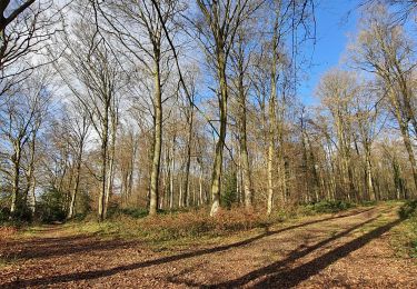
super Rando en forêt.