![](/images/other/stat-length.png)
![Trail Walking Octeville-sur-Mer - Octeville sur Mer / la ferme aquatique / Octeville sur Mer - Photo](https://media.geolcdn.com/t/1900/400/ed85ff22-e57a-49a3-856e-cd8f1bc12579.jpg&format=pjpeg&maxdim=2)
Octeville sur Mer / la ferme aquatique / Octeville sur Mer
MarcherEnsemble
User
![Length](/images/other/stat-length.png)
Length
10.4 km
![Max alt](https://static1.geolcdn.com/siteimages/upload/files/1508320355ic_sort_altitude_max_24dp.png)
Max alt
102 m
![Uphill gradient](https://static1.geolcdn.com/siteimages/upload/files/1508320355ic_sort_den_pos_24dp.png)
Uphill gradient
78 m
![Km-Effort](/images/other/stat-length.png)
Km-Effort
11.5 km
![Min alt](https://static1.geolcdn.com/siteimages/upload/files/1508320355ic_sort_altitude_min_24dp.png)
Min alt
71 m
![Downhill gradient](https://static1.geolcdn.com/siteimages/upload/files/1508320355ic_sort_den_neg_24dp.png)
Downhill gradient
77 m
![Boucle](https://static1.geolcdn.com/siteimages/upload/files/16400158638029165_repeat_loop_refresh_sync_direction_icon.png)
Boucle
Yes
Creation date :
2020-08-03 07:23:13.588
Updated on :
2020-08-03 14:17:49.416
![Walking](https://static1.geolcdn.com/sitytour/trail-icons/101.png)
2h31
Difficulty : Very easy
![Scan this QR Code to open this trail in the SityTrail application](https://capi.geolives.com/qq0zvz2zws4bq2lad0pu/sitytour/trails/2500359/qr.png?size=200)
FREE GPS app for hiking
About
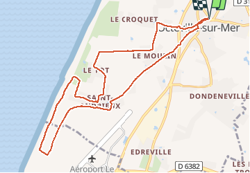
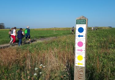
Trail Walking of 10.4 km to be discovered at Normandy, Seine-Maritime, Octeville-sur-Mer. This trail is proposed by MarcherEnsemble.
Description
Départ du parking de la salle de sport d'Octeville Michel Adam.
Les plus courageux pourront descendre au bord de l'eau et remonter par le chemin de chèvres.
Attention un ou deux passages très près du bord de la falaise 😰
Positioning
Country:
France
Region :
Normandy
Department/Province :
Seine-Maritime
Municipality :
Octeville-sur-Mer
Location:
Unknown
Start:(Dec)
Start:(UTM)
291636 ; 5493334 (31U) N.
Comments
Trails nearby
![Trail On foot Fontaine-la-Mallet - Les Bassins des Vallées - Photo](https://media.geolcdn.com/t/375/260/ce57ffe6-f4ea-486c-bc79-47861158f9a7.jpeg&format=jpg&maxdim=2)
![On foot On foot](https://static1.geolcdn.com/sitytour/trail-icons/100.png)
Les Bassins des Vallées
On foot
Easy
Fontaine-la-Mallet,
Normandy,
Seine-Maritime,
France
![](/images/other/stat-length.png)
5.1 km | 6 km-effort
1h 21min
![](https://static1.geolcdn.com/siteimages/upload/files/16400158638029165_repeat_loop_refresh_sync_direction_icon.png)
No
![Trail On foot Le Havre - Parc de Rouelles - GR - 16-09-2024 - Photo](https://media.geolcdn.com/t/375/260/ext.jpg?maxdim=2&url=https%3A%2F%2Fstatic1.geolcdn.com%2Fsiteimages%2Fupload%2Ffiles%2F1545311037marcheuse_200dpi.jpg)
![On foot On foot](https://static1.geolcdn.com/sitytour/trail-icons/100.png)
Parc de Rouelles - GR - 16-09-2024
On foot
Easy
(1)
Le Havre,
Normandy,
Seine-Maritime,
France
![](/images/other/stat-length.png)
9.4 km | 11.6 km-effort
2h 37min
![](https://static1.geolcdn.com/siteimages/upload/files/16400158638029165_repeat_loop_refresh_sync_direction_icon.png)
Yes
![Trail Walking Fontenay - Le Fontenay - 10-07-23 - Circuit court - Photo](https://media.geolcdn.com/t/375/260/ext.jpg?maxdim=2&url=https%3A%2F%2Fstatic1.geolcdn.com%2Fsiteimages%2Fupload%2Ffiles%2F1553511878bg_sport_marche.png)
![Walking Walking](https://static1.geolcdn.com/sitytour/trail-icons/101.png)
Le Fontenay - 10-07-23 - Circuit court
Walking
Medium
(1)
Fontenay,
Normandy,
Seine-Maritime,
France
![](/images/other/stat-length.png)
7.1 km | 8.3 km-effort
1h 53min
![](https://static1.geolcdn.com/siteimages/upload/files/16400158638029165_repeat_loop_refresh_sync_direction_icon.png)
Yes
![Trail Walking Fontenay - Le Fontenay - 10-07-23 - Photo](https://media.geolcdn.com/t/375/260/ext.jpg?maxdim=2&url=https%3A%2F%2Fstatic1.geolcdn.com%2Fsiteimages%2Fupload%2Ffiles%2F1553511878bg_sport_marche.png)
![Walking Walking](https://static1.geolcdn.com/sitytour/trail-icons/101.png)
Le Fontenay - 10-07-23
Walking
Medium
(1)
Fontenay,
Normandy,
Seine-Maritime,
France
![](/images/other/stat-length.png)
9.7 km | 11.1 km-effort
2h 31min
![](https://static1.geolcdn.com/siteimages/upload/files/16400158638029165_repeat_loop_refresh_sync_direction_icon.png)
Yes
![Trail Walking Le Havre - parc rouelles mini pas - Photo](https://media.geolcdn.com/t/375/260/4828ec3b-0ba5-48a6-a7b6-2d96d2df242a.jpg&format=jpg&maxdim=2)
![Walking Walking](https://static1.geolcdn.com/sitytour/trail-icons/101.png)
parc rouelles mini pas
Walking
Easy
Le Havre,
Normandy,
Seine-Maritime,
France
![](/images/other/stat-length.png)
3.1 km | 3.6 km-effort
49min
![](https://static1.geolcdn.com/siteimages/upload/files/16400158638029165_repeat_loop_refresh_sync_direction_icon.png)
Yes
![Trail Walking Le Havre - rouelles jarfleur - Photo](https://media.geolcdn.com/t/375/260/5ae05f62-481a-4ec4-9ff2-2462690d422c.jpg&format=jpg&maxdim=2)
![Walking Walking](https://static1.geolcdn.com/sitytour/trail-icons/101.png)
rouelles jarfleur
Walking
Easy
Le Havre,
Normandy,
Seine-Maritime,
France
![](/images/other/stat-length.png)
11.8 km | 13.5 km-effort
2h 21min
![](https://static1.geolcdn.com/siteimages/upload/files/16400158638029165_repeat_loop_refresh_sync_direction_icon.png)
Yes
![Trail Walking Mannevillette - Manevillette - Photo](https://media.geolcdn.com/t/375/260/ac876953-8dc4-43c6-b79b-f344f5908c23.jpg&format=jpg&maxdim=2)
![Walking Walking](https://static1.geolcdn.com/sitytour/trail-icons/101.png)
Manevillette
Walking
Very easy
Mannevillette,
Normandy,
Seine-Maritime,
France
![](/images/other/stat-length.png)
9.9 km | 10.7 km-effort
2h 28min
![](https://static1.geolcdn.com/siteimages/upload/files/16400158638029165_repeat_loop_refresh_sync_direction_icon.png)
Yes
![Trail Walking Fontaine-la-Mallet - Le Havre: Forêt de Montgeon variante N°4 - Photo](https://media.geolcdn.com/t/375/260/8b15d953-6666-4ab2-ae83-cbcb0c4950af.jpg&format=jpg&maxdim=2)
![Walking Walking](https://static1.geolcdn.com/sitytour/trail-icons/101.png)
Le Havre: Forêt de Montgeon variante N°4
Walking
Very easy
(1)
Fontaine-la-Mallet,
Normandy,
Seine-Maritime,
France
![](/images/other/stat-length.png)
8.5 km | 10.7 km-effort
2h 29min
![](https://static1.geolcdn.com/siteimages/upload/files/16400158638029165_repeat_loop_refresh_sync_direction_icon.png)
Yes
![Trail Walking Montivilliers - Montivilliers / Eprémesnil / Parc La Bouteillerie / Montivilliers - Photo](https://media.geolcdn.com/t/375/260/ext.jpg?maxdim=2&url=https%3A%2F%2Fservices.sitytrail.com%2FGeolivesWS%2FDownloadMedia.ashx%3FTrailID%3D717248%26Media%3Dfix__20170320112756.jpg)
![Walking Walking](https://static1.geolcdn.com/sitytour/trail-icons/101.png)
Montivilliers / Eprémesnil / Parc La Bouteillerie / Montivilliers
Walking
Easy
Montivilliers,
Normandy,
Seine-Maritime,
France
![](/images/other/stat-length.png)
10 km | 11.8 km-effort
2h 33min
![](https://static1.geolcdn.com/siteimages/upload/files/16400158638029165_repeat_loop_refresh_sync_direction_icon.png)
Yes