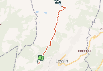
![](/images/other/stat-length.png)
![Trail Other activity Leysin - Leysin - Mayen - Photo](https://media.geolcdn.com/t/1900/400/ext.pjpeg?maxdim=2&url=https%3A%2F%2Fstatic1.geolcdn.com%2Fsiteimages%2Fupload%2Ffiles%2F1545311037marcheuse_200dpi.jpg)
Leysin - Mayen
steve
User
![Length](/images/other/stat-length.png)
Length
3.6 km
![Max alt](https://static1.geolcdn.com/siteimages/upload/files/1508320355ic_sort_altitude_max_24dp.png)
Max alt
1844 m
![Uphill gradient](https://static1.geolcdn.com/siteimages/upload/files/1508320355ic_sort_den_pos_24dp.png)
Uphill gradient
371 m
![Km-Effort](/images/other/stat-length.png)
Km-Effort
7.3 km
![Min alt](https://static1.geolcdn.com/siteimages/upload/files/1508320355ic_sort_altitude_min_24dp.png)
Min alt
1477 m
![Downhill gradient](https://static1.geolcdn.com/siteimages/upload/files/1508320355ic_sort_den_neg_24dp.png)
Downhill gradient
10 m
![Boucle](https://static1.geolcdn.com/siteimages/upload/files/16400158638029165_repeat_loop_refresh_sync_direction_icon.png)
Boucle
No
Creation date :
2014-12-11 00:00:00.0
Updated on :
2014-12-11 00:00:00.0
![Other activity](https://static1.geolcdn.com/sitytour/trail-icons/900.png)
--
Difficulty : Unknown
![Scan this QR Code to open this trail in the SityTrail application](https://capi.geolives.com/qq0zvz2zws4bq2lad0pu/sitytour/trails/24995/qr.png?size=200)
FREE GPS app for hiking
About
Trail Other activity of 3.6 km to be discovered at Vaud, District d'Aigle, Leysin. This trail is proposed by steve.
Description
A faire en raquettes, à pied ou en peaux de phoques. Si celà est possible, prévoir une luge ou un sac poubelle pour se laisser glisser lors de la descente.
On peut pousser la randonnée jusqu''à Aïe et même la Berneuse.
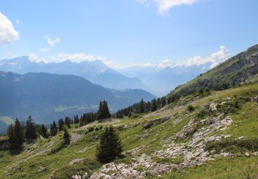
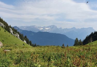
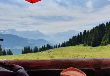
Magnifique point de vue
Positioning
Country:
Switzerland
Region :
Vaud
Department/Province :
District d'Aigle
Municipality :
Leysin
Location:
Unknown
Start:(Dec)
Start:(UTM)
346098 ; 5134032 (32T) N.
Comments
Trails nearby
![Trail On foot Leysin - Luan-Ai - Photo](https://media.geolcdn.com/t/375/260/e64df634-6ebe-4f26-95ea-e745ebe191d1.jpeg&format=jpg&maxdim=2)
![On foot On foot](https://static1.geolcdn.com/sitytour/trail-icons/100.png)
![Trail Walking Ollon - Le grand Chamossaire - Photo](https://media.geolcdn.com/t/375/260/a67746b6-a3a3-4764-a01c-8939bef03c6f.jpg&format=jpg&maxdim=2)
![Walking Walking](https://static1.geolcdn.com/sitytour/trail-icons/101.png)
Le grand Chamossaire
Walking
Medium
Ollon,
Vaud,
District d'Aigle,
Switzerland
![](/images/other/stat-length.png)
6.6 km | 15.6 km-effort
3h 48min
![](https://static1.geolcdn.com/siteimages/upload/files/16400158638029165_repeat_loop_refresh_sync_direction_icon.png)
No
![Trail Walking Leysin - la Rionda - Photo](https://media.geolcdn.com/t/375/260/056e7ba8-0a74-43ec-ad7f-8ecd97b06ea2.jpg&format=jpg&maxdim=2)
![Walking Walking](https://static1.geolcdn.com/sitytour/trail-icons/101.png)
la Rionda
Walking
Medium
Leysin,
Vaud,
District d'Aigle,
Switzerland
![](/images/other/stat-length.png)
7.4 km | 11.2 km-effort
2h 33min
![](https://static1.geolcdn.com/siteimages/upload/files/16400158638029165_repeat_loop_refresh_sync_direction_icon.png)
No
![Trail Other activity Leysin - bdr00_Leysin_StGingolphe - Photo](https://media.geolcdn.com/t/375/260/ext.jpg?maxdim=2&url=https%3A%2F%2Fstatic1.geolcdn.com%2Fsiteimages%2Fupload%2Ffiles%2F1545311037marcheuse_200dpi.jpg)
![Other activity Other activity](https://static1.geolcdn.com/sitytour/trail-icons/900.png)
bdr00_Leysin_StGingolphe
Other activity
Very easy
Leysin,
Vaud,
District d'Aigle,
Switzerland
![](/images/other/stat-length.png)
26 km | 32 km-effort
Unknown
![](https://static1.geolcdn.com/siteimages/upload/files/16400158638029165_repeat_loop_refresh_sync_direction_icon.png)
No
![Trail Other activity Leysin - xxx00_Leysin_StGingolphe - Photo](https://media.geolcdn.com/t/375/260/ext.jpg?maxdim=2&url=https%3A%2F%2Fstatic1.geolcdn.com%2Fsiteimages%2Fupload%2Ffiles%2F1545311037marcheuse_200dpi.jpg)
![Other activity Other activity](https://static1.geolcdn.com/sitytour/trail-icons/900.png)
xxx00_Leysin_StGingolphe
Other activity
Very easy
Leysin,
Vaud,
District d'Aigle,
Switzerland
![](/images/other/stat-length.png)
26 km | 32 km-effort
6h 41min
![](https://static1.geolcdn.com/siteimages/upload/files/16400158638029165_repeat_loop_refresh_sync_direction_icon.png)
No
![Trail Mountain bike Leysin - Bike32915 - Photo](https://media.geolcdn.com/t/375/260/ext.jpg?maxdim=2&url=https%3A%2F%2Fstatic1.geolcdn.com%2Fsiteimages%2Fupload%2Ffiles%2F1524743154velo.jpg)
![Mountain bike Mountain bike](https://static1.geolcdn.com/sitytour/trail-icons/202.png)
Bike32915
Mountain bike
Very easy
Leysin,
Vaud,
District d'Aigle,
Switzerland
![](/images/other/stat-length.png)
30 km | 49 km-effort
Unknown
![](https://static1.geolcdn.com/siteimages/upload/files/16400158638029165_repeat_loop_refresh_sync_direction_icon.png)
Yes
![Trail Walking Aigle - Aigle montagne - Photo](https://media.geolcdn.com/t/375/260/ext.jpg?maxdim=2&url=https%3A%2F%2Fstatic1.geolcdn.com%2Fsiteimages%2Fupload%2Ffiles%2F1553511878bg_sport_marche.png)
![Walking Walking](https://static1.geolcdn.com/sitytour/trail-icons/101.png)
Aigle montagne
Walking
Very easy
Aigle,
Vaud,
District d'Aigle,
Switzerland
![](/images/other/stat-length.png)
3.9 km | 12 km-effort
58min
![](https://static1.geolcdn.com/siteimages/upload/files/16400158638029165_repeat_loop_refresh_sync_direction_icon.png)
No
![Trail Walking Leysin - solacyre - Photo](https://media.geolcdn.com/t/375/260/5de8fdef-0956-4e6c-8e7f-e135750b4469.jpg&format=jpg&maxdim=2)
![Walking Walking](https://static1.geolcdn.com/sitytour/trail-icons/101.png)
solacyre
Walking
Easy
Leysin,
Vaud,
District d'Aigle,
Switzerland
![](/images/other/stat-length.png)
2.7 km | 6.3 km-effort
1h 20min
![](https://static1.geolcdn.com/siteimages/upload/files/16400158638029165_repeat_loop_refresh_sync_direction_icon.png)
No
![Trail Mountain bike Aigle - m-zwitserland-alpine-bike - Photo](https://media.geolcdn.com/t/375/260/ext.jpg?maxdim=2&url=https%3A%2F%2Fstatic1.geolcdn.com%2Fsiteimages%2Fupload%2Ffiles%2F1524743154velo.jpg)
![Mountain bike Mountain bike](https://static1.geolcdn.com/sitytour/trail-icons/202.png)
m-zwitserland-alpine-bike
Mountain bike
Very easy
Aigle,
Vaud,
District d'Aigle,
Switzerland
![](/images/other/stat-length.png)
660 km | 988 km-effort
Unknown
![](https://static1.geolcdn.com/siteimages/upload/files/16400158638029165_repeat_loop_refresh_sync_direction_icon.png)
No