![](/images/other/stat-length.png)
![Trail Other activity Fournet-Blancheroche - Soubey - Les Brenets 2/2 - Photo](https://media.geolcdn.com/t/1900/400/ext.pjpeg?maxdim=2&url=https%3A%2F%2Fstatic1.geolcdn.com%2Fsiteimages%2Fupload%2Ffiles%2F1545311037marcheuse_200dpi.jpg)
Soubey - Les Brenets 2/2
steve
User
![Length](/images/other/stat-length.png)
Length
21 km
![Max alt](https://static1.geolcdn.com/siteimages/upload/files/1508320355ic_sort_altitude_max_24dp.png)
Max alt
878 m
![Uphill gradient](https://static1.geolcdn.com/siteimages/upload/files/1508320355ic_sort_den_pos_24dp.png)
Uphill gradient
1058 m
![Km-Effort](/images/other/stat-length.png)
Km-Effort
34 km
![Min alt](https://static1.geolcdn.com/siteimages/upload/files/1508320355ic_sort_altitude_min_24dp.png)
Min alt
609 m
![Downhill gradient](https://static1.geolcdn.com/siteimages/upload/files/1508320355ic_sort_den_neg_24dp.png)
Downhill gradient
793 m
![Boucle](https://static1.geolcdn.com/siteimages/upload/files/16400158638029165_repeat_loop_refresh_sync_direction_icon.png)
Boucle
No
Creation date :
2016-03-09 00:00:00.0
Updated on :
2016-03-09 00:00:00.0
![Other activity](https://static1.geolcdn.com/sitytour/trail-icons/900.png)
--
Difficulty : Unknown
![Scan this QR Code to open this trail in the SityTrail application](https://capi.geolives.com/qq0zvz2zws4bq2lad0pu/sitytour/trails/24988/qr.png?size=200)
FREE GPS app for hiking
About
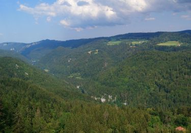
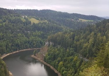
Trail Other activity of 21 km to be discovered at Bourgogne-Franche-Comté, Doubs, Fournet-Blancheroche. This trail is proposed by steve.
Description
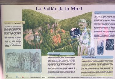
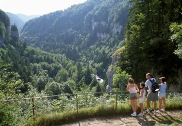
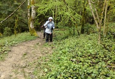
Magnifique rendonnée. A faire par temps beau. Prévoir de bonnes chaussures de marche, les sentiers sont parfois glissants. Sentier didactique sur les mémoires du Doubs. Difficultée facil mais endurant.
Positioning
Country:
France
Region :
Bourgogne-Franche-Comté
Department/Province :
Doubs
Municipality :
Fournet-Blancheroche
Location:
Unknown
Start:(Dec)
Start:(UTM)
337648 ; 5225640 (32T) N.
Comments
Trails nearby
![Trail Walking Charquemont - Échelles de la mort - Photo](https://media.geolcdn.com/t/375/260/7b9848bb-a43e-4c47-8544-5e7b63b496f6.jpg&format=jpg&maxdim=2)
![Walking Walking](https://static1.geolcdn.com/sitytour/trail-icons/101.png)
Échelles de la mort
Walking
Medium
(1)
Charquemont,
Bourgogne-Franche-Comté,
Doubs,
France
![](/images/other/stat-length.png)
6.5 km | 9.5 km-effort
1h 33min
![](https://static1.geolcdn.com/siteimages/upload/files/16400158638029165_repeat_loop_refresh_sync_direction_icon.png)
Yes
![Trail Walking Charquemont - Les Echelles de la Mort - Doubs - Photo](https://media.geolcdn.com/t/375/260/ext.jpg?maxdim=2&url=https%3A%2F%2Fservices.sitytrail.com%2FGeolivesWS%2FDownloadMedia.ashx%3FTrailID%3D108929%26Media%3D2620_1.jpg)
![Walking Walking](https://static1.geolcdn.com/sitytour/trail-icons/101.png)
Les Echelles de la Mort - Doubs
Walking
Medium
(2)
Charquemont,
Bourgogne-Franche-Comté,
Doubs,
France
![](/images/other/stat-length.png)
8.4 km | 14.1 km-effort
3h 0min
![](https://static1.geolcdn.com/siteimages/upload/files/16400158638029165_repeat_loop_refresh_sync_direction_icon.png)
Yes
![Trail Walking Fournet-Blancheroche - Combe de Biaufond - Photo](https://media.geolcdn.com/t/375/260/ext.jpg?maxdim=2&url=https%3A%2F%2Fstatic1.geolcdn.com%2Fsiteimages%2Fupload%2Ffiles%2F1553511878bg_sport_marche.png)
![Walking Walking](https://static1.geolcdn.com/sitytour/trail-icons/101.png)
Combe de Biaufond
Walking
Medium
(1)
Fournet-Blancheroche,
Bourgogne-Franche-Comté,
Doubs,
France
![](/images/other/stat-length.png)
11.7 km | 18.3 km-effort
4h 17min
![](https://static1.geolcdn.com/siteimages/upload/files/16400158638029165_repeat_loop_refresh_sync_direction_icon.png)
No
![Trail sport Charquemont - Charquemont - Photo](https://media.geolcdn.com/t/375/260/2f6ea34c-c41e-4747-afa9-f8bc25b75ed3.jpg&format=jpg&maxdim=2)
Charquemont
sport
Very easy
Charquemont,
Bourgogne-Franche-Comté,
Doubs,
France
![](/images/other/stat-length.png)
5.5 km | 7.9 km-effort
Unknown
![](https://static1.geolcdn.com/siteimages/upload/files/16400158638029165_repeat_loop_refresh_sync_direction_icon.png)
Yes
![Trail Walking Charquemont - lçendre cha4quemond - Photo](https://media.geolcdn.com/t/375/260/d4b171d3-4707-4b81-9ad5-a84cf10f6378.jpg&format=jpg&maxdim=2)
![Walking Walking](https://static1.geolcdn.com/sitytour/trail-icons/101.png)
lçendre cha4quemond
Walking
Very difficult
Charquemont,
Bourgogne-Franche-Comté,
Doubs,
France
![](/images/other/stat-length.png)
13.2 km | 22 km-effort
5h 55min
![](https://static1.geolcdn.com/siteimages/upload/files/16400158638029165_repeat_loop_refresh_sync_direction_icon.png)
Yes
![Trail Walking Charquemont - Combes Saint Pierre - Photo](https://media.geolcdn.com/t/375/260/0b54ab85-de60-4572-870a-d1ef0de23798.jpg&format=jpg&maxdim=2)
![Walking Walking](https://static1.geolcdn.com/sitytour/trail-icons/101.png)
Combes Saint Pierre
Walking
Easy
(1)
Charquemont,
Bourgogne-Franche-Comté,
Doubs,
France
![](/images/other/stat-length.png)
5.9 km | 8 km-effort
3h 29min
![](https://static1.geolcdn.com/siteimages/upload/files/16400158638029165_repeat_loop_refresh_sync_direction_icon.png)
Yes
![Trail Walking Charquemont - Goumois-Le Boulois / Les échelles de la mort - Photo](https://media.geolcdn.com/t/375/260/e486823a-bed9-43a4-abeb-bf237649de07.jpg&format=jpg&maxdim=2)
![Walking Walking](https://static1.geolcdn.com/sitytour/trail-icons/101.png)
Goumois-Le Boulois / Les échelles de la mort
Walking
Medium
Charquemont,
Bourgogne-Franche-Comté,
Doubs,
France
![](/images/other/stat-length.png)
15.9 km | 26 km-effort
3h 14min
![](https://static1.geolcdn.com/siteimages/upload/files/16400158638029165_repeat_loop_refresh_sync_direction_icon.png)
Yes
![Trail Walking Charquemont - LES ECHELLES DE LA MORT - Photo](https://media.geolcdn.com/t/375/260/eedace1f-3156-432d-a68f-d4e4629d6189.jpg&format=jpg&maxdim=2)
![Walking Walking](https://static1.geolcdn.com/sitytour/trail-icons/101.png)
LES ECHELLES DE LA MORT
Walking
Difficult
Charquemont,
Bourgogne-Franche-Comté,
Doubs,
France
![](/images/other/stat-length.png)
10.4 km | 17.1 km-effort
4h 42min
![](https://static1.geolcdn.com/siteimages/upload/files/16400158638029165_repeat_loop_refresh_sync_direction_icon.png)
Yes
![Trail Mountain bike Fournet-Blancheroche - j3 - Photo](https://media.geolcdn.com/t/375/260/3ef35ac2-9dde-466b-8bee-c8943e098f1e.jpg&format=jpg&maxdim=2)
![Mountain bike Mountain bike](https://static1.geolcdn.com/sitytour/trail-icons/202.png)
j3
Mountain bike
Difficult
Fournet-Blancheroche,
Bourgogne-Franche-Comté,
Doubs,
France
![](/images/other/stat-length.png)
53 km | 69 km-effort
4h 50min
![](https://static1.geolcdn.com/siteimages/upload/files/16400158638029165_repeat_loop_refresh_sync_direction_icon.png)
No