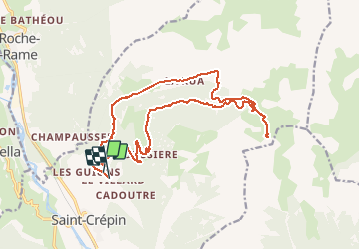
![](/images/other/stat-length.png)
![Trail Mountain bike Saint-Crépin - Le lac Lauzet et les Grangettes au départ du villard de St-Crépin - Photo](https://media.geolcdn.com/t/1900/400/ext.pjpeg?maxdim=2&url=https%3A%2F%2Fstatic1.geolcdn.com%2Fsiteimages%2Fupload%2Ffiles%2F1524743154velo.jpg)
Le lac Lauzet et les Grangettes au départ du villard de St-Crépin
Forain
User
![Length](/images/other/stat-length.png)
![Max alt](https://static1.geolcdn.com/siteimages/upload/files/1508320355ic_sort_altitude_max_24dp.png)
![Uphill gradient](https://static1.geolcdn.com/siteimages/upload/files/1508320355ic_sort_den_pos_24dp.png)
![Km-Effort](/images/other/stat-length.png)
![Min alt](https://static1.geolcdn.com/siteimages/upload/files/1508320355ic_sort_altitude_min_24dp.png)
![Downhill gradient](https://static1.geolcdn.com/siteimages/upload/files/1508320355ic_sort_den_neg_24dp.png)
![Boucle](https://static1.geolcdn.com/siteimages/upload/files/16400158638029165_repeat_loop_refresh_sync_direction_icon.png)
![Mountain bike](https://static1.geolcdn.com/sitytour/trail-icons/202.png)
2h59
Difficulty : Difficult
![Scan this QR Code to open this trail in the SityTrail application](https://capi.geolives.com/qq0zvz2zws4bq2lad0pu/sitytour/trails/2498002/qr.png?size=200)
FREE GPS app for hiking
About
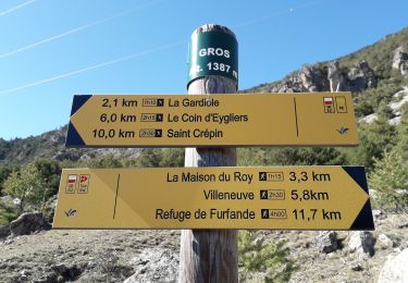
Trail Mountain bike of 22 km to be discovered at Provence-Alpes-Côte d'Azur, Hautes-Alpes, Saint-Crépin. This trail is proposed by Forain.
Description
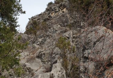
La montée est assez raide au début(4km) suivi d'une section plus roulante, suivi d'un final plus grimpant avec au sommet un petit lac d’altitude. Le retour ce fait par la voie de montée sur environ 1,7km avant de bifurquer sur un petit chemin de randonnée à droite(au niveau de la cabane du Lauzet) en direction des Grangettes. Le début de ce sentier est technique pour devenir de plus en plus roulant.
Positioning
Comments
Trails nearby
![Trail Walking Freissinières - crête en bordure vallée Freissinieres - Photo](https://media.geolcdn.com/t/375/260/ext.jpg?maxdim=2&url=https%3A%2F%2Fservices.sitytrail.com%2FGeolivesWS%2FDownloadMedia.ashx%3FTrailID%3D615510%26Media%3Dfix__20160816131321.jpg)
![Walking Walking](https://static1.geolcdn.com/sitytour/trail-icons/101.png)
Walking
![](/images/other/stat-length.png)
![](https://static1.geolcdn.com/siteimages/upload/files/16400158638029165_repeat_loop_refresh_sync_direction_icon.png)
![Trail Walking Eygliers - crots les Girars - Photo](https://media.geolcdn.com/t/375/260/1984f172-53b4-4530-81bd-f8dbb8a69056.jpg&format=jpg&maxdim=2)
![Walking Walking](https://static1.geolcdn.com/sitytour/trail-icons/101.png)
Walking
![](/images/other/stat-length.png)
![](https://static1.geolcdn.com/siteimages/upload/files/16400158638029165_repeat_loop_refresh_sync_direction_icon.png)
![Trail Walking Champcella - Gouffre de Gourfouran - Photo](https://media.geolcdn.com/t/375/260/e71c0816-5ea3-48b2-a638-eb4844c01261.jpg&format=jpg&maxdim=2)
![Walking Walking](https://static1.geolcdn.com/sitytour/trail-icons/101.png)
Walking
![](/images/other/stat-length.png)
![](https://static1.geolcdn.com/siteimages/upload/files/16400158638029165_repeat_loop_refresh_sync_direction_icon.png)
![Trail Walking Champcella - FRESSINIERES - SEYES 16.3KM - Photo](https://media.geolcdn.com/t/375/260/ext.jpg?maxdim=2&url=https%3A%2F%2Fservices.sitytrail.com%2FGeolivesWS%2FDownloadMedia.ashx%3FTrailID%3D453121%26Media%3Daf20fe3c-1968-4140-9440-e6d14a0bf00b.jpg)
![Walking Walking](https://static1.geolcdn.com/sitytour/trail-icons/101.png)
Walking
![](/images/other/stat-length.png)
![](https://static1.geolcdn.com/siteimages/upload/files/16400158638029165_repeat_loop_refresh_sync_direction_icon.png)
![Trail Walking Eygliers - eygliers - Photo](https://media.geolcdn.com/t/375/260/4d2fa757-82b4-42b5-b98d-a01be8317965.jpg&format=jpg&maxdim=2)
![Walking Walking](https://static1.geolcdn.com/sitytour/trail-icons/101.png)
Walking
![](/images/other/stat-length.png)
![](https://static1.geolcdn.com/siteimages/upload/files/16400158638029165_repeat_loop_refresh_sync_direction_icon.png)
![Trail Walking Saint-Crépin - St Crépin Thurifère vers hameau de Guion Chantal - Photo](https://media.geolcdn.com/t/375/260/c1ee07d4-05f0-443a-a59c-bf145194c732.jpg&format=jpg&maxdim=2)
![Walking Walking](https://static1.geolcdn.com/sitytour/trail-icons/101.png)
Walking
![](/images/other/stat-length.png)
![](https://static1.geolcdn.com/siteimages/upload/files/16400158638029165_repeat_loop_refresh_sync_direction_icon.png)
![Trail Walking Eygliers - Gros cabannes Tourouder - Photo](https://media.geolcdn.com/t/375/260/316d45c1-9e6e-42ed-8767-48fc2893efef.jpg&format=jpg&maxdim=2)
![Walking Walking](https://static1.geolcdn.com/sitytour/trail-icons/101.png)
Walking
![](/images/other/stat-length.png)
![](https://static1.geolcdn.com/siteimages/upload/files/16400158638029165_repeat_loop_refresh_sync_direction_icon.png)
![Trail Walking Champcella - 2020-09-10 Balade Gouffre du Gourfouran - Photo](https://media.geolcdn.com/t/375/260/bfedcf14-c21e-4e5e-9a44-ef10f0f1a645.jpg&format=jpg&maxdim=2)
![Walking Walking](https://static1.geolcdn.com/sitytour/trail-icons/101.png)
Walking
![](/images/other/stat-length.png)
![](https://static1.geolcdn.com/siteimages/upload/files/16400158638029165_repeat_loop_refresh_sync_direction_icon.png)
![Trail Walking La Roche-de-Rame - Le Pic du haut Mouriare et le lac de l'Ascension - Photo](https://media.geolcdn.com/t/375/260/8e7aa451-d695-4417-922a-7f908363131f.jpg&format=jpg&maxdim=2)
![Walking Walking](https://static1.geolcdn.com/sitytour/trail-icons/101.png)
Walking
![](/images/other/stat-length.png)
![](https://static1.geolcdn.com/siteimages/upload/files/16400158638029165_repeat_loop_refresh_sync_direction_icon.png)