![](/images/other/stat-length.png)
Aups - Pic de l'aigle - Les Cugulons.
Sugg
User
![Length](/images/other/stat-length.png)
Length
17.3 km
![Max alt](https://static1.geolcdn.com/siteimages/upload/files/1508320355ic_sort_altitude_max_24dp.png)
Max alt
974 m
![Uphill gradient](https://static1.geolcdn.com/siteimages/upload/files/1508320355ic_sort_den_pos_24dp.png)
Uphill gradient
477 m
![Km-Effort](/images/other/stat-length.png)
Km-Effort
24 km
![Min alt](https://static1.geolcdn.com/siteimages/upload/files/1508320355ic_sort_altitude_min_24dp.png)
Min alt
644 m
![Downhill gradient](https://static1.geolcdn.com/siteimages/upload/files/1508320355ic_sort_den_neg_24dp.png)
Downhill gradient
475 m
![Boucle](https://static1.geolcdn.com/siteimages/upload/files/16400158638029165_repeat_loop_refresh_sync_direction_icon.png)
Boucle
Yes
Creation date :
2019-03-22 17:00:17.793
Updated on :
2019-03-22 17:00:17.948
![Walking](https://static1.geolcdn.com/sitytour/trail-icons/101.png)
5h08
Difficulty : Medium
![Scan this QR Code to open this trail in the SityTrail application](https://capi.geolives.com/qq0zvz2zws4bq2lad0pu/sitytour/trails/249690/qr.png?size=200)
FREE GPS app for hiking
About
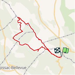
Trail Walking of 17.3 km to be discovered at Provence-Alpes-Côte d'Azur, Var, Aups. This trail is proposed by Sugg.
Description
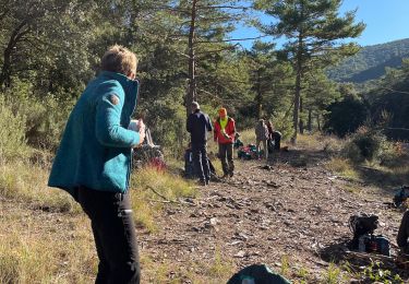
Rando avec Restons en Forme du 12 février 2014.Guide : Pierre
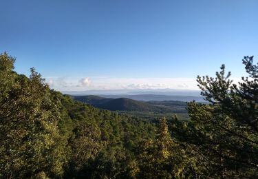
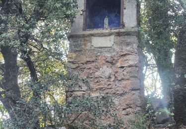
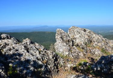
Très beau parcours jusqu'à la citerne en 767, en passant par le pylône de l'Aigle en 982.
Pas mal de grimpettes sur le retour, beau point de vue en 810.
PS : comme d'hab,la durée comprend les arrêts et le pique nique .
Positioning
Country:
France
Region :
Provence-Alpes-Côte d'Azur
Department/Province :
Var
Municipality :
Aups
Location:
Unknown
Start:(Dec)
Start:(UTM)
276362 ; 4838091 (32T) N.
Comments
Trails nearby
![Trail Walking Aups - Tour de la montagne des Espiguières - Photo](https://media.geolcdn.com/t/375/260/431b4009-bb72-41ce-bf82-1eb70c111177.jpg&format=jpg&maxdim=2)
![Walking Walking](https://static1.geolcdn.com/sitytour/trail-icons/101.png)
Tour de la montagne des Espiguières
Walking
Difficult
(1)
Aups,
Provence-Alpes-Côte d'Azur,
Var,
France
![](/images/other/stat-length.png)
11 km | 15.4 km-effort
3h 30min
![](https://static1.geolcdn.com/siteimages/upload/files/16400158638029165_repeat_loop_refresh_sync_direction_icon.png)
Yes
![Trail Walking Vérignon - 2024-01-30 Vérignon - Chapelle Saint Priest - Photo](https://media.geolcdn.com/t/375/260/bc33279d-e419-4c1d-b671-4cabd4fbe480.jpg&format=jpg&maxdim=2)
![Walking Walking](https://static1.geolcdn.com/sitytour/trail-icons/101.png)
2024-01-30 Vérignon - Chapelle Saint Priest
Walking
Difficult
Vérignon,
Provence-Alpes-Côte d'Azur,
Var,
France
![](/images/other/stat-length.png)
10.5 km | 14.6 km-effort
3h 19min
![](https://static1.geolcdn.com/siteimages/upload/files/16400158638029165_repeat_loop_refresh_sync_direction_icon.png)
Yes
![Trail Walking Aups - 2023-01-31 Col de la Bigue - Les Eyssariades - Photo](https://media.geolcdn.com/t/375/260/039bb7ef-09c0-4f59-a7b3-09433c82c531.jpg&format=jpg&maxdim=2)
![Walking Walking](https://static1.geolcdn.com/sitytour/trail-icons/101.png)
2023-01-31 Col de la Bigue - Les Eyssariades
Walking
Medium
Aups,
Provence-Alpes-Côte d'Azur,
Var,
France
![](/images/other/stat-length.png)
16.3 km | 23 km-effort
4h 41min
![](https://static1.geolcdn.com/siteimages/upload/files/16400158638029165_repeat_loop_refresh_sync_direction_icon.png)
Yes
![Trail Walking Aups - 30-10-2022 Aups Sentier des Crêtes - Photo](https://media.geolcdn.com/t/375/260/032d8805-e093-4b3d-aca0-89dc5544919a.jpg&format=jpg&maxdim=2)
![Walking Walking](https://static1.geolcdn.com/sitytour/trail-icons/101.png)
30-10-2022 Aups Sentier des Crêtes
Walking
Medium
Aups,
Provence-Alpes-Côte d'Azur,
Var,
France
![](/images/other/stat-length.png)
20 km | 31 km-effort
5h 0min
![](https://static1.geolcdn.com/siteimages/upload/files/16400158638029165_repeat_loop_refresh_sync_direction_icon.png)
Yes
![Trail Running Moissac-Bellevue - TRAIL DE MOISSAC 2016 10KM +330 - Photo](https://media.geolcdn.com/t/375/260/ext.jpg?maxdim=2&url=https%3A%2F%2Fservices.sitytrail.com%2FGeolivesWS%2FDownloadMedia.ashx%3FTrailID%3D540393%26Media%3Dfix__20160319134649.jpg)
![Running Running](https://static1.geolcdn.com/sitytour/trail-icons/103.png)
TRAIL DE MOISSAC 2016 10KM +330
Running
Difficult
(1)
Moissac-Bellevue,
Provence-Alpes-Côte d'Azur,
Var,
France
![](/images/other/stat-length.png)
9.7 km | 14.2 km-effort
1h 35min
![](https://static1.geolcdn.com/siteimages/upload/files/16400158638029165_repeat_loop_refresh_sync_direction_icon.png)
Yes
![Trail Walking Aups - 2025-01-21 Montagne des Espiguières - Photo](https://media.geolcdn.com/t/375/260/1e29026a-5d46-486c-967e-572a0d99d84f.jpg&format=jpg&maxdim=2)
![Walking Walking](https://static1.geolcdn.com/sitytour/trail-icons/101.png)
2025-01-21 Montagne des Espiguières
Walking
Difficult
Aups,
Provence-Alpes-Côte d'Azur,
Var,
France
![](/images/other/stat-length.png)
11.6 km | 17.9 km-effort
4h 3min
![](https://static1.geolcdn.com/siteimages/upload/files/16400158638029165_repeat_loop_refresh_sync_direction_icon.png)
Yes
![Trail Walking Vérignon - Verignon Notre Dame de Liesse Chapelle Saint Priest trace réelle - Photo](https://media.geolcdn.com/t/375/260/06e1804b-1eee-444e-ab93-f67bc999bfbe.jpg&format=jpg&maxdim=2)
![Walking Walking](https://static1.geolcdn.com/sitytour/trail-icons/101.png)
Verignon Notre Dame de Liesse Chapelle Saint Priest trace réelle
Walking
Very difficult
Vérignon,
Provence-Alpes-Côte d'Azur,
Var,
France
![](/images/other/stat-length.png)
19.2 km | 29 km-effort
6h 30min
![](https://static1.geolcdn.com/siteimages/upload/files/16400158638029165_repeat_loop_refresh_sync_direction_icon.png)
Yes
![Trail Walking Aups - Aups - Photo](https://media.geolcdn.com/t/375/260/fd86a7ef-4f3e-4db0-8d1f-50f58d38a091.jpg&format=jpg&maxdim=2)
![Walking Walking](https://static1.geolcdn.com/sitytour/trail-icons/101.png)
Vérignon - ND Liesse - Moure de Cuiller - Chapelle St Priest
Walking
Difficult
Vérignon,
Provence-Alpes-Côte d'Azur,
Var,
France
![](/images/other/stat-length.png)
18 km | 27 km-effort
4h 26min
![](https://static1.geolcdn.com/siteimages/upload/files/16400158638029165_repeat_loop_refresh_sync_direction_icon.png)
Yes
Tres belle randonnée, à faire quand il ne fait pas trop chaud
magnifique