![](/images/other/stat-length.png)
![Trail Mountain bike Varces-Allières-et-Risset - tour du Cornafion par col de l'Arc et col Vert - Photo](https://media.geolcdn.com/t/1900/400/ext.pjpeg?maxdim=2&url=https%3A%2F%2Fmedia.geolcdn.com%2Ff%2Fed419b48-96d1-4afd-b336-4324cb35bedc.jpg)
tour du Cornafion par col de l'Arc et col Vert
© OpenStreetMap contributors
![Mountain bike](https://static1.geolcdn.com/sitytour/trail-icons/202.png)
Mountain bike
6h12
Difficulty : Difficult
![Length](/images/other/stat-length.png)
Length
36 km
![Max alt](https://static1.geolcdn.com/siteimages/upload/files/1508320355ic_sort_altitude_max_24dp.png)
Max alt
1746 m
![Uphill gradient](https://static1.geolcdn.com/siteimages/upload/files/1508320355ic_sort_den_pos_24dp.png)
Uphill gradient
1890 m
![Km-Effort](/images/other/stat-length.png)
Km-Effort
61 km
![Min alt](https://static1.geolcdn.com/siteimages/upload/files/1508320355ic_sort_altitude_min_24dp.png)
Min alt
276 m
![Downhill gradient](https://static1.geolcdn.com/siteimages/upload/files/1508320355ic_sort_den_neg_24dp.png)
Downhill gradient
1887 m
![Boucle](https://static1.geolcdn.com/siteimages/upload/files/16400158638029165_repeat_loop_refresh_sync_direction_icon.png)
Boucle
Yes
Creation date :
2020-07-30 07:02:54.753
Updated on :
2020-07-31 16:29:35.83
![Mountain bike](https://static1.geolcdn.com/sitytour/trail-icons/202.png)
6h12
Difficulty : Difficult
![Scan this QR Code to open this trail in the SityTrail application](https://capi.geolives.com/qq0zvz2zws4bq2lad0pu/sitytour/trails/2495774/qr.png?size=200)
FREE GPS app for hiking
About
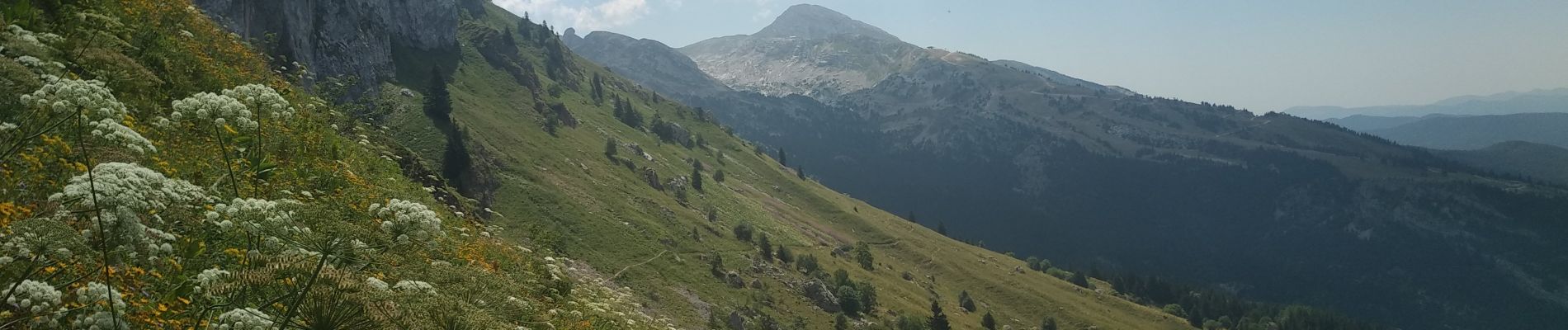
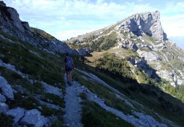
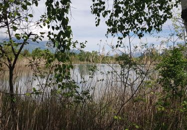
Trail Mountain bike of 36 km to be discovered at Auvergne-Rhône-Alpes, Isère, Varces-Allières-et-Risset. This trail is proposed by Yannick Pietruszewski.
Description
canicule en vallée, bon en altitude, sentiers bien sec comme on aime, pas mal de randonneurs près des cols. Attention, parcours avec beaucoup de portage et poussage
Positioning
Country:
France
Region :
Auvergne-Rhône-Alpes
Department/Province :
Isère
Municipality :
Varces-Allières-et-Risset
Location:
Unknown
Start:(Dec)
Start:(UTM)
710758 ; 4996100 (31T) N.
Comments
Trails nearby
![Trail Walking Claix - caba - Photo](https://media.geolcdn.com/t/375/260/ext.jpg?maxdim=2&url=https%3A%2F%2Fstatic1.geolcdn.com%2Fsiteimages%2Fupload%2Ffiles%2F1553511878bg_sport_marche.png)
![Walking Walking](https://static1.geolcdn.com/sitytour/trail-icons/101.png)
caba
Walking
Very easy
(1)
Claix,
Auvergne-Rhône-Alpes,
Isère,
France
![](/images/other/stat-length.png)
8.7 km | 16.6 km-effort
5h 2min
![](https://static1.geolcdn.com/siteimages/upload/files/16400158638029165_repeat_loop_refresh_sync_direction_icon.png)
Yes
![Trail Nordic walking Claix - Le Peuil 5 Km - Photo](https://media.geolcdn.com/t/375/260/ext.jpg?maxdim=2&url=https%3A%2F%2Fstatic1.geolcdn.com%2Fsiteimages%2Fupload%2Ffiles%2F1545311037marcheuse_200dpi.jpg)
![Nordic walking Nordic walking](https://static1.geolcdn.com/sitytour/trail-icons/102.png)
Le Peuil 5 Km
Nordic walking
Easy
(1)
Claix,
Auvergne-Rhône-Alpes,
Isère,
France
![](/images/other/stat-length.png)
5.3 km | 7.1 km-effort
1h 28min
![](https://static1.geolcdn.com/siteimages/upload/files/16400158638029165_repeat_loop_refresh_sync_direction_icon.png)
Yes
![Trail Walking Champ-sur-Drac - 38 Couvent St Michel Champ / drac - Photo](https://media.geolcdn.com/t/375/260/ext.jpg?maxdim=2&url=https%3A%2F%2Fmedia.geolcdn.com%2Ff%2F2541c209-e2b9-4fc5-ac0c-29659bf67ee5.jpg)
![Walking Walking](https://static1.geolcdn.com/sitytour/trail-icons/101.png)
38 Couvent St Michel Champ / drac
Walking
Medium
Champ-sur-Drac,
Auvergne-Rhône-Alpes,
Isère,
France
![](/images/other/stat-length.png)
9.4 km | 19.7 km-effort
3h 0min
![](https://static1.geolcdn.com/siteimages/upload/files/16400158638029165_repeat_loop_refresh_sync_direction_icon.png)
Yes
![Trail Walking Varces-Allières-et-Risset - Les Etangs de Reymure réaménagés en 2023. - Photo](https://media.geolcdn.com/t/375/260/ext.jpg?maxdim=2&url=https%3A%2F%2Fmedia.geolcdn.com%2Ff%2Fa9036917-cc32-4324-8d0a-4d872f501612.jpg)
![Walking Walking](https://static1.geolcdn.com/sitytour/trail-icons/101.png)
Les Etangs de Reymure réaménagés en 2023.
Walking
Medium
Varces-Allières-et-Risset,
Auvergne-Rhône-Alpes,
Isère,
France
![](/images/other/stat-length.png)
7.9 km | 8.6 km-effort
2h 35min
![](https://static1.geolcdn.com/siteimages/upload/files/16400158638029165_repeat_loop_refresh_sync_direction_icon.png)
Yes
![Trail Walking Vif - la ferme oriol en circuit - Photo](https://media.geolcdn.com/t/375/260/ext.jpg?maxdim=2&url=https%3A%2F%2Fmedia.geolcdn.com%2Ff%2F40456475-f1df-45a6-819a-93e9ddb16412.jpg)
![Walking Walking](https://static1.geolcdn.com/sitytour/trail-icons/101.png)
la ferme oriol en circuit
Walking
Very difficult
Vif,
Auvergne-Rhône-Alpes,
Isère,
France
![](/images/other/stat-length.png)
13.7 km | 24 km-effort
3h 15min
![](https://static1.geolcdn.com/siteimages/upload/files/16400158638029165_repeat_loop_refresh_sync_direction_icon.png)
Yes
![Trail Walking Claix - La Tourbière du Peuil - Photo](https://media.geolcdn.com/t/375/260/ext.jpg?maxdim=2&url=https%3A%2F%2Fmedia.geolcdn.com%2Ff%2F12a96e27-edba-4d2b-ae09-b32ddf1adbb4.jpg)
![Walking Walking](https://static1.geolcdn.com/sitytour/trail-icons/101.png)
La Tourbière du Peuil
Walking
Easy
Claix,
Auvergne-Rhône-Alpes,
Isère,
France
![](/images/other/stat-length.png)
4 km | 5.4 km-effort
1h 13min
![](https://static1.geolcdn.com/siteimages/upload/files/16400158638029165_repeat_loop_refresh_sync_direction_icon.png)
Yes
![Trail Nordic walking Vif - Les Etangs de la Plaine de Reymure - Photo](https://media.geolcdn.com/t/375/260/ext.jpg?maxdim=2&url=https%3A%2F%2Fmedia.geolcdn.com%2Ff%2F1d6be850-f5d4-4e8e-a42b-a881c0492ad2.jpg)
![Nordic walking Nordic walking](https://static1.geolcdn.com/sitytour/trail-icons/102.png)
Les Etangs de la Plaine de Reymure
Nordic walking
Easy
Vif,
Auvergne-Rhône-Alpes,
Isère,
France
![](/images/other/stat-length.png)
9.4 km | 10.3 km-effort
2h 0min
![](https://static1.geolcdn.com/siteimages/upload/files/16400158638029165_repeat_loop_refresh_sync_direction_icon.png)
Yes
![Trail Walking Claix - Traversée Le Peuil - Le Pré du Four - Retour par la cabane de La Robine - Photo](https://media.geolcdn.com/t/375/260/ext.jpg?maxdim=2&url=https%3A%2F%2Fmedia.geolcdn.com%2Ff%2F910cc0e9-4f5c-4c48-a8a7-87d4365e7188.jpg)
![Walking Walking](https://static1.geolcdn.com/sitytour/trail-icons/101.png)
Traversée Le Peuil - Le Pré du Four - Retour par la cabane de La Robine
Walking
Medium
Claix,
Auvergne-Rhône-Alpes,
Isère,
France
![](/images/other/stat-length.png)
13.4 km | 23 km-effort
4h 1min
![](https://static1.geolcdn.com/siteimages/upload/files/16400158638029165_repeat_loop_refresh_sync_direction_icon.png)
Yes
![Trail Nordic walking Varces-Allières-et-Risset - De la plaine de Reymure au canal de Malissolles - Photo](https://media.geolcdn.com/t/375/260/ext.jpg?maxdim=2&url=https%3A%2F%2Fmedia.geolcdn.com%2Ff%2F3d91b17d-7f71-4e45-96ae-37747dd4929a.jpg)
![Nordic walking Nordic walking](https://static1.geolcdn.com/sitytour/trail-icons/102.png)
De la plaine de Reymure au canal de Malissolles
Nordic walking
Easy
Varces-Allières-et-Risset,
Auvergne-Rhône-Alpes,
Isère,
France
![](/images/other/stat-length.png)
9.1 km | 10.3 km-effort
2h 1min
![](https://static1.geolcdn.com/siteimages/upload/files/16400158638029165_repeat_loop_refresh_sync_direction_icon.png)
Yes