![](/images/other/stat-length.png)
![Trail Mountain bike Jougne - Belcoster Poyette - Photo](https://media.geolcdn.com/t/1900/400/ext.pjpeg?maxdim=2&url=https%3A%2F%2Fstatic1.geolcdn.com%2Fsiteimages%2Fupload%2Ffiles%2F1524743154velo.jpg)
Belcoster Poyette
Michel Vermot
User
![Length](/images/other/stat-length.png)
Length
19.2 km
![Max alt](https://static1.geolcdn.com/siteimages/upload/files/1508320355ic_sort_altitude_max_24dp.png)
Max alt
1396 m
![Uphill gradient](https://static1.geolcdn.com/siteimages/upload/files/1508320355ic_sort_den_pos_24dp.png)
Uphill gradient
632 m
![Km-Effort](/images/other/stat-length.png)
Km-Effort
28 km
![Min alt](https://static1.geolcdn.com/siteimages/upload/files/1508320355ic_sort_altitude_min_24dp.png)
Min alt
870 m
![Downhill gradient](https://static1.geolcdn.com/siteimages/upload/files/1508320355ic_sort_den_neg_24dp.png)
Downhill gradient
634 m
![Boucle](https://static1.geolcdn.com/siteimages/upload/files/16400158638029165_repeat_loop_refresh_sync_direction_icon.png)
Boucle
Yes
Creation date :
2020-07-30 08:13:41.466
Updated on :
2020-07-30 10:14:22.505
![Mountain bike](https://static1.geolcdn.com/sitytour/trail-icons/202.png)
1h33
Difficulty : Medium
![Scan this QR Code to open this trail in the SityTrail application](https://capi.geolives.com/qq0zvz2zws4bq2lad0pu/sitytour/trails/2495581/qr.png?size=200)
FREE GPS app for hiking
About
Trail Mountain bike of 19.2 km to be discovered at Bourgogne-Franche-Comté, Doubs, Jougne. This trail is proposed by Michel Vermot.
Description
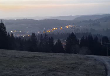
Petit tour sympa depuis les Echampès (commune de Jougne) jusqu'au pied du Suchet. Beaux point de vue sur la chaîne des Alpes
Positioning
Country:
France
Region :
Bourgogne-Franche-Comté
Department/Province :
Doubs
Municipality :
Jougne
Location:
Unknown
Start:(Dec)
Start:(UTM)
300436 ; 5179226 (32T) N.
Comments
Trails nearby
![Trail Mountain bike Vallorbe - Le Suchet - Photo](https://media.geolcdn.com/t/375/260/ext.jpg?maxdim=2&url=https%3A%2F%2Fstatic1.geolcdn.com%2Fsiteimages%2Fupload%2Ffiles%2F1524743154velo.jpg)
![Mountain bike Mountain bike](https://static1.geolcdn.com/sitytour/trail-icons/202.png)
Le Suchet
Mountain bike
Very easy
(1)
Vallorbe,
Vaud,
District du Jura-Nord vaudois,
Switzerland
![](/images/other/stat-length.png)
35 km | 53 km-effort
14h 41min
![](https://static1.geolcdn.com/siteimages/upload/files/16400158638029165_repeat_loop_refresh_sync_direction_icon.png)
Yes
![Trail On foot Vallorbe - Mont d'Orzeires - Le Pont Gare - Photo](https://media.geolcdn.com/t/375/260/7e9156be-5722-477c-ab77-407a4f623ffb.jpeg&format=jpg&maxdim=2)
![On foot On foot](https://static1.geolcdn.com/sitytour/trail-icons/100.png)
Mont d'Orzeires - Le Pont Gare
On foot
Easy
Vallorbe,
Vaud,
District du Jura-Nord vaudois,
Switzerland
![](/images/other/stat-length.png)
3.2 km | 4.4 km-effort
59min
![](https://static1.geolcdn.com/siteimages/upload/files/16400158638029165_repeat_loop_refresh_sync_direction_icon.png)
No
![Trail On foot Ballaigues - Ballaigues-Vallorbe - Photo](https://media.geolcdn.com/t/375/260/94e39ae2-cd96-4289-ab6b-b58b7f70c35d.jpeg&format=jpg&maxdim=2)
![On foot On foot](https://static1.geolcdn.com/sitytour/trail-icons/100.png)
Ballaigues-Vallorbe
On foot
Easy
Ballaigues,
Vaud,
District du Jura-Nord vaudois,
Switzerland
![](/images/other/stat-length.png)
5.1 km | 6.3 km-effort
1h 25min
![](https://static1.geolcdn.com/siteimages/upload/files/16400158638029165_repeat_loop_refresh_sync_direction_icon.png)
No
![Trail Walking Jougne - Aiguilles de Baulmes - Suisse - Photo](https://media.geolcdn.com/t/375/260/ext.jpg?maxdim=2&url=https%3A%2F%2Fstatic1.geolcdn.com%2Fsiteimages%2Fupload%2Ffiles%2F1553511878bg_sport_marche.png)
![Walking Walking](https://static1.geolcdn.com/sitytour/trail-icons/101.png)
Aiguilles de Baulmes - Suisse
Walking
Difficult
(1)
Jougne,
Bourgogne-Franche-Comté,
Doubs,
France
![](/images/other/stat-length.png)
16.4 km | 26 km-effort
5h 33min
![](https://static1.geolcdn.com/siteimages/upload/files/16400158638029165_repeat_loop_refresh_sync_direction_icon.png)
Yes
![Trail Walking Métabief - GTJ Metabief - Pontarlier - Photo](https://media.geolcdn.com/t/375/260/ext.jpg?maxdim=2&url=https%3A%2F%2Fstatic1.geolcdn.com%2Fsiteimages%2Fupload%2Ffiles%2F1553511878bg_sport_marche.png)
![Walking Walking](https://static1.geolcdn.com/sitytour/trail-icons/101.png)
GTJ Metabief - Pontarlier
Walking
Medium
(1)
Métabief,
Bourgogne-Franche-Comté,
Doubs,
France
![](/images/other/stat-length.png)
25 km | 35 km-effort
7h 17min
![](https://static1.geolcdn.com/siteimages/upload/files/16400158638029165_repeat_loop_refresh_sync_direction_icon.png)
No
![Trail Walking Métabief - Le mont d 0r - Photo](https://media.geolcdn.com/t/375/260/dfbdcbfb-f5e1-43ae-8768-86e7f8471cb6.jpg&format=jpg&maxdim=2)
![Walking Walking](https://static1.geolcdn.com/sitytour/trail-icons/101.png)
Le mont d 0r
Walking
Medium
Métabief,
Bourgogne-Franche-Comté,
Doubs,
France
![](/images/other/stat-length.png)
18.5 km | 25 km-effort
4h 38min
![](https://static1.geolcdn.com/siteimages/upload/files/16400158638029165_repeat_loop_refresh_sync_direction_icon.png)
No
![Trail Snowshoes Métabief - Les hauteurs de Metabief - Photo](https://media.geolcdn.com/t/375/260/33f04111-8af2-4c09-927f-ba23e9559149.jpg&format=jpg&maxdim=2)
![Snowshoes Snowshoes](https://static1.geolcdn.com/sitytour/trail-icons/504.png)
Les hauteurs de Metabief
Snowshoes
Medium
(1)
Métabief,
Bourgogne-Franche-Comté,
Doubs,
France
![](/images/other/stat-length.png)
15.5 km | 23 km-effort
3h 51min
![](https://static1.geolcdn.com/siteimages/upload/files/16400158638029165_repeat_loop_refresh_sync_direction_icon.png)
Yes
![Trail Walking Jougne - La Jougnena - Photo](https://media.geolcdn.com/t/375/260/ext.jpg?maxdim=2&url=https%3A%2F%2Fstatic1.geolcdn.com%2Fsiteimages%2Fupload%2Ffiles%2F1553511878bg_sport_marche.png)
![Walking Walking](https://static1.geolcdn.com/sitytour/trail-icons/101.png)
La Jougnena
Walking
Very difficult
(1)
Jougne,
Bourgogne-Franche-Comté,
Doubs,
France
![](/images/other/stat-length.png)
17.7 km | 24 km-effort
5h 32min
![](https://static1.geolcdn.com/siteimages/upload/files/16400158638029165_repeat_loop_refresh_sync_direction_icon.png)
Yes
![Trail Walking Jougne - La poyette - Photo](https://media.geolcdn.com/t/375/260/7455827d-3f9e-4079-9524-3e53ae00a5a5.jpg&format=jpg&maxdim=2)
![Walking Walking](https://static1.geolcdn.com/sitytour/trail-icons/101.png)
La poyette
Walking
Medium
Jougne,
Bourgogne-Franche-Comté,
Doubs,
France
![](/images/other/stat-length.png)
11.8 km | 17.9 km-effort
4h 7min
![](https://static1.geolcdn.com/siteimages/upload/files/16400158638029165_repeat_loop_refresh_sync_direction_icon.png)
Yes