Trail Walking Aime-la-Plagne - LA PLAGNE MONTALBERT : Bief Beauvais - Les Adrets - Sentier de la biodiversité. - Photo

LA PLAGNE MONTALBERT : Bief Beauvais - Les Adrets - Sentier de la biodiversité.

 lucnxdb
lucnxdb

User

© OpenStreetMap contributors
Length
Length
12.1 km
Max alt
Max alt
1978 m
Uphill gradient
Uphill gradient
578 m
Km-Effort
Km-Effort  
19.9 km
Min alt
Min alt
1389 m
Downhill gradient
Downhill gradient
625 m
Boucle
Boucle
No
Creation date :
2020-07-28 06:48:09.114
Updated on :
2020-07-28 12:52:06.662

(0 Reviews)

Walking
Walking
3h07
Difficulty : Easy

Scan this QR Code to open this trail in the SityTrail application

FREE GPS app for hiking

Logo SityTrail SityTrail

IGN / Geographical institutes

Download SityTrail from the App Store Download SityTrail from Google Play

Logo SityTrail SityTrail World

The world is yours!

Download SityTrail from the App Store Download SityTrail from Google Play Download SityTrail on Huawei AppGallery

About

Trail Walking of 12.1 km to be discovered at Auvergne-Rhône-Alpes, Savoy, Aime-la-Plagne. This trail is proposed by lucnxdb.

Description

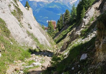
Bief Bovet : Départ assez raide, très beau sentier longeant le petit ruisseau (bief)
Les Adrets : point d'arrivée Télécabine de MONTALBERT domine un petit point d'eau d'une dizaine de mètres de profondeur, pour alimentation canons à neige (vue sur PLAGNE 2000 et PLAGNE 1800)
Sentier de la Biodiversité : très beau, ombragé, et intéressant

Elevation profile

Positioning

Country:
France
Region :
Auvergne-Rhône-Alpes
Department/Province :
Savoy
Municipality :
Aime-la-Plagne
Location:
Aime
Start:(UTM)
316021 ; 5044736 (32T) N.

Trails nearby

Trail On foot Aime-la-Plagne - Le Mont Jovet - Photo
On foot
GUIDE+

On foot

Medium
Aime-la-Plagne, Auvergne-Rhône-Alpes, Savoy, France
11.1 km | 21 km-effort
4h 45min
Yes
Trail On foot La Plagne-Tarentaise - Les Frasses - Photo
On foot
GUIDE+

On foot

Easy
La Plagne-Tarentaise, Auvergne-Rhône-Alpes, Savoy, France
5.7 km | 7.8 km-effort
1h 45min
No
Trail On foot La Plagne-Tarentaise - Boucle du Carroley - Photo
On foot
GUIDE+

On foot

Easy
La Plagne-Tarentaise, Auvergne-Rhône-Alpes, Savoy, France
4.2 km | 7.5 km-effort
1h 41min
No
Trail On foot La Plagne-Tarentaise - Sentier Découverte Grande Rochette - Photo
On foot
GUIDE+

On foot

Easy
La Plagne-Tarentaise, Auvergne-Rhône-Alpes, Savoy, France
9.2 km | 16.3 km-effort
3h 42min
Yes
Trail On foot La Plagne-Tarentaise - Boucle de Roche de Mio - Photo
On foot
GUIDE+

On foot

Easy
La Plagne-Tarentaise, Auvergne-Rhône-Alpes, Savoy, France
5.6 km | 12.1 km-effort
2h 44min
No
Trail On foot Aime-la-Plagne - Route Balcon - Photo
On foot
GUIDE+

On foot

Easy
Aime-la-Plagne, Auvergne-Rhône-Alpes, Savoy, France
7.4 km | 9.6 km-effort
2h 11min
No
Trail On foot La Plagne-Tarentaise - Le Lac Vert - Photo
On foot
GUIDE+

On foot

Easy
La Plagne-Tarentaise, Auvergne-Rhône-Alpes, Savoy, France
4.6 km | 7 km-effort
1h 36min
Yes
Trail Walking Aime-la-Plagne - Balcons de Granier - Photo
Walking
patrando49

Walking

Easy
(2)
Aime-la-Plagne, Auvergne-Rhône-Alpes, Savoy, France
7.3 km | 12.6 km-effort
2h 48min
Yes
Trail Walking La Plagne-Tarentaise - Plagne Soleil, La Grande Rochette, Plagne Centre  - Photo
Walking
GUIDE
lhomme.ph

Walking

Difficult
La Plagne-Tarentaise, Auvergne-Rhône-Alpes, Savoy, France
8.6 km | 14.5 km-effort
2h 57min
No


Close
My subscriptions