![](/images/other/stat-length.png)
![Trail Walking Nandrin - nandrin (villers-le-temple) randonnée de la rochette - Photo](https://media.geolcdn.com/t/1900/400/ext.pjpeg?maxdim=2&url=https%3A%2F%2Fstatic1.geolcdn.com%2Fsiteimages%2Fupload%2Ffiles%2F1553511878bg_sport_marche.png)
nandrin (villers-le-temple) randonnée de la rochette
jmltp14
User
![Length](/images/other/stat-length.png)
Length
5.2 km
![Max alt](https://static1.geolcdn.com/siteimages/upload/files/1508320355ic_sort_altitude_max_24dp.png)
Max alt
236 m
![Uphill gradient](https://static1.geolcdn.com/siteimages/upload/files/1508320355ic_sort_den_pos_24dp.png)
Uphill gradient
111 m
![Km-Effort](/images/other/stat-length.png)
Km-Effort
6.7 km
![Min alt](https://static1.geolcdn.com/siteimages/upload/files/1508320355ic_sort_altitude_min_24dp.png)
Min alt
184 m
![Downhill gradient](https://static1.geolcdn.com/siteimages/upload/files/1508320355ic_sort_den_neg_24dp.png)
Downhill gradient
111 m
![Boucle](https://static1.geolcdn.com/siteimages/upload/files/16400158638029165_repeat_loop_refresh_sync_direction_icon.png)
Boucle
Yes
Creation date :
2020-07-25 13:22:27.845
Updated on :
2020-07-25 13:55:04.823
![Walking](https://static1.geolcdn.com/sitytour/trail-icons/101.png)
1h30
Difficulty : Medium
![Scan this QR Code to open this trail in the SityTrail application](https://capi.geolives.com/qq0zvz2zws4bq2lad0pu/sitytour/trails/2489378/qr.png?size=200)
FREE GPS app for hiking
About
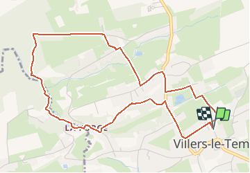
Trail Walking of 5.2 km to be discovered at Wallonia, Liège, Nandrin. This trail is proposed by jmltp14.
Description
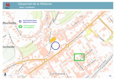
Cette très jolie promenade vous permet de passer dans un village de vieille pierres avant de longer un ruisseau bucolique . Vous pouvez vous arrêter à la Rochette avant de grimper sur le plateau et de revenir vers le village par des sentiers bien agréables.
Positioning
Country:
Belgium
Region :
Wallonia
Department/Province :
Liège
Municipality :
Nandrin
Location:
Villers-le-Temple
Start:(Dec)
Start:(UTM)
668043 ; 5597936 (31U) N.
Comments
Trails nearby
![Trail Walking Modave - Rausa GR 575 bis - Photo](https://media.geolcdn.com/t/375/260/ext.jpg?maxdim=2&url=https%3A%2F%2Fstatic1.geolcdn.com%2Fsiteimages%2Fupload%2Ffiles%2F1553511878bg_sport_marche.png)
![Walking Walking](https://static1.geolcdn.com/sitytour/trail-icons/101.png)
Rausa GR 575 bis
Walking
Easy
(12)
Modave,
Wallonia,
Liège,
Belgium
![](/images/other/stat-length.png)
6 km | 7.7 km-effort
1h 38min
![](https://static1.geolcdn.com/siteimages/upload/files/16400158638029165_repeat_loop_refresh_sync_direction_icon.png)
Yes
![Trail Walking Nandrin - Villers le temple . st jean sart . clemaude - Photo](https://media.geolcdn.com/t/375/260/c7438fda-ad3c-4a12-91ed-f3aabfc6b7ce.jpg&format=jpg&maxdim=2)
![Walking Walking](https://static1.geolcdn.com/sitytour/trail-icons/101.png)
Villers le temple . st jean sart . clemaude
Walking
Very easy
(1)
Nandrin,
Wallonia,
Liège,
Belgium
![](/images/other/stat-length.png)
7.9 km | 10.4 km-effort
2h 12min
![](https://static1.geolcdn.com/siteimages/upload/files/16400158638029165_repeat_loop_refresh_sync_direction_icon.png)
Yes
![Trail Walking Modave - MODAVE - Froide Fontaine - Photo](https://media.geolcdn.com/t/375/260/ext.jpg?maxdim=2&url=https%3A%2F%2Fservices.sitytrail.com%2FGeolivesWS%2FDownloadMedia.ashx%3FTrailID%3D163540%26Media%3Da9dfd4e0-07be-4695-be31-23a02d75fa1f.jpg)
![Walking Walking](https://static1.geolcdn.com/sitytour/trail-icons/101.png)
MODAVE - Froide Fontaine
Walking
Medium
(2)
Modave,
Wallonia,
Liège,
Belgium
![](/images/other/stat-length.png)
8.6 km | 10.6 km-effort
2h 14min
![](https://static1.geolcdn.com/siteimages/upload/files/16400158638029165_repeat_loop_refresh_sync_direction_icon.png)
Yes
![Trail Mountain bike Amay - casse gueul - Photo](https://media.geolcdn.com/t/375/260/ext.jpg?maxdim=2&url=https%3A%2F%2Fservices.sitytrail.com%2FGeolivesWS%2FDownloadMedia.ashx%3FTrailID%3D285464%26Media%3Dfix__20140511121633.jpg)
![Mountain bike Mountain bike](https://static1.geolcdn.com/sitytour/trail-icons/202.png)
casse gueul
Mountain bike
Difficult
(1)
Amay,
Wallonia,
Liège,
Belgium
![](/images/other/stat-length.png)
27 km | 33 km-effort
2h 21min
![](https://static1.geolcdn.com/siteimages/upload/files/16400158638029165_repeat_loop_refresh_sync_direction_icon.png)
No
![Trail Walking Nandrin - promenade de la rochette : villers le temple - grand fond d'oxhe - villers le temple - Photo](https://media.geolcdn.com/t/375/260/6a65eaf0-07ca-4e09-ab79-c1ffba2fba6b.jpg&format=jpg&maxdim=2)
![Walking Walking](https://static1.geolcdn.com/sitytour/trail-icons/101.png)
promenade de la rochette : villers le temple - grand fond d'oxhe - villers le...
Walking
Medium
(1)
Nandrin,
Wallonia,
Liège,
Belgium
![](/images/other/stat-length.png)
10 km | 13.3 km-effort
2h 47min
![](https://static1.geolcdn.com/siteimages/upload/files/16400158638029165_repeat_loop_refresh_sync_direction_icon.png)
Yes
![Trail Walking Modave - Stree reco 21 12 - Photo](https://media.geolcdn.com/t/375/260/ext.jpg?maxdim=2&url=https%3A%2F%2Fstatic1.geolcdn.com%2Fsiteimages%2Fupload%2Ffiles%2F1553511878bg_sport_marche.png)
![Walking Walking](https://static1.geolcdn.com/sitytour/trail-icons/101.png)
Stree reco 21 12
Walking
Medium
(2)
Modave,
Wallonia,
Liège,
Belgium
![](/images/other/stat-length.png)
7.6 km | 9.3 km-effort
1h 55min
![](https://static1.geolcdn.com/siteimages/upload/files/16400158638029165_repeat_loop_refresh_sync_direction_icon.png)
Yes
![Trail Walking Amay - 20230726 - TOTEMUS Amay - 6.1 Km - Photo](https://media.geolcdn.com/t/375/260/4112cd7d-32fc-4690-94e7-6dc07eacc03d.jpeg&format=jpg&maxdim=2)
![Walking Walking](https://static1.geolcdn.com/sitytour/trail-icons/101.png)
20230726 - TOTEMUS Amay - 6.1 Km
Walking
Medium
Amay,
Wallonia,
Liège,
Belgium
![](/images/other/stat-length.png)
6.1 km | 6.6 km-effort
1h 42min
![](https://static1.geolcdn.com/siteimages/upload/files/16400158638029165_repeat_loop_refresh_sync_direction_icon.png)
Yes
![Trail On foot Amay - Promenade d'Ombret - Photo](https://media.geolcdn.com/t/375/260/bbfa7314-541b-4540-af6f-869e2bd08b94.jpeg&format=jpg&maxdim=2)
![On foot On foot](https://static1.geolcdn.com/sitytour/trail-icons/100.png)
![Trail Walking Nandrin - Balade des bois de Yernée - Photo](https://media.geolcdn.com/t/375/260/ext.jpg?maxdim=2&url=https%3A%2F%2Fstatic1.geolcdn.com%2Fsiteimages%2Fupload%2Ffiles%2F1553511878bg_sport_marche.png)
![Walking Walking](https://static1.geolcdn.com/sitytour/trail-icons/101.png)
Balade des bois de Yernée
Walking
Easy
(1)
Nandrin,
Wallonia,
Liège,
Belgium
![](/images/other/stat-length.png)
9.1 km | 11.8 km-effort
2h 9min
![](https://static1.geolcdn.com/siteimages/upload/files/16400158638029165_repeat_loop_refresh_sync_direction_icon.png)
Yes
TROP DE MONTÉE ET DESCENTE