![](/images/other/stat-length.png)
![Trail Walking Saint-Martin-la-Plaine - 20200723...De St-Martin-la-Plaine à Ste Catherine - Photo](https://media.geolcdn.com/t/1900/400/ext.pjpeg?maxdim=2&url=https%3A%2F%2Fmedia.geolcdn.com%2Ff%2Fde2332cd-f39e-4b4b-833f-13d4f905f3e7.jpg)
20200723...De St-Martin-la-Plaine à Ste Catherine
galain
User
![Length](/images/other/stat-length.png)
Length
26 km
![Max alt](https://static1.geolcdn.com/siteimages/upload/files/1508320355ic_sort_altitude_max_24dp.png)
Max alt
823 m
![Uphill gradient](https://static1.geolcdn.com/siteimages/upload/files/1508320355ic_sort_den_pos_24dp.png)
Uphill gradient
701 m
![Km-Effort](/images/other/stat-length.png)
Km-Effort
36 km
![Min alt](https://static1.geolcdn.com/siteimages/upload/files/1508320355ic_sort_altitude_min_24dp.png)
Min alt
313 m
![Downhill gradient](https://static1.geolcdn.com/siteimages/upload/files/1508320355ic_sort_den_neg_24dp.png)
Downhill gradient
701 m
![Boucle](https://static1.geolcdn.com/siteimages/upload/files/16400158638029165_repeat_loop_refresh_sync_direction_icon.png)
Boucle
Yes
Creation date :
2020-07-23 07:08:48.0
Updated on :
2020-07-24 10:03:59.495
![Walking](https://static1.geolcdn.com/sitytour/trail-icons/101.png)
6h11
Difficulty : Medium
![Scan this QR Code to open this trail in the SityTrail application](https://capi.geolives.com/qq0zvz2zws4bq2lad0pu/sitytour/trails/2487081/qr.png?size=200)
FREE GPS app for hiking
About
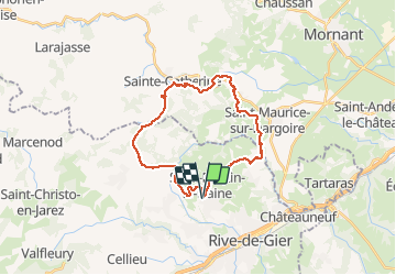
Trail Walking of 26 km to be discovered at Auvergne-Rhône-Alpes, Loire, Saint-Martin-la-Plaine. This trail is proposed by galain.
Description
Joli parcours en boucle de 26 kms empruntant parfois l'ancien tracé d'une ligne de chemin de fer et de belles grimpettes en perspective.
Possibilité de casser la croûte à plusieurs endroits.
Positioning
Country:
France
Region :
Auvergne-Rhône-Alpes
Department/Province :
Loire
Municipality :
Saint-Martin-la-Plaine
Location:
Unknown
Start:(Dec)
Start:(UTM)
624022 ; 5044990 (31T) N.
Comments
Trails nearby
![Trail Walking La Grand-Croix - MOYENNE MARCHE - Photo](https://media.geolcdn.com/t/375/260/ext.jpg?maxdim=2&url=https%3A%2F%2Fstatic1.geolcdn.com%2Fsiteimages%2Fupload%2Ffiles%2F1553511878bg_sport_marche.png)
![Walking Walking](https://static1.geolcdn.com/sitytour/trail-icons/101.png)
MOYENNE MARCHE
Walking
Very easy
(1)
La Grand-Croix,
Auvergne-Rhône-Alpes,
Loire,
France
![](/images/other/stat-length.png)
3.8 km | 5 km-effort
1h 1min
![](https://static1.geolcdn.com/siteimages/upload/files/16400158638029165_repeat_loop_refresh_sync_direction_icon.png)
Yes
![Trail Walking Chagnon - 42_Chagnon_13km470m - Photo](https://media.geolcdn.com/t/375/260/ext.jpg?maxdim=2&url=https%3A%2F%2Fmedia.geolcdn.com%2Ff%2F7ea874cc-cd00-4c8f-a5f4-5d79cdc17a88.jpg)
![Walking Walking](https://static1.geolcdn.com/sitytour/trail-icons/101.png)
42_Chagnon_13km470m
Walking
Medium
Chagnon,
Auvergne-Rhône-Alpes,
Loire,
France
![](/images/other/stat-length.png)
13.1 km | 19.3 km-effort
2h 58min
![](https://static1.geolcdn.com/siteimages/upload/files/16400158638029165_repeat_loop_refresh_sync_direction_icon.png)
Yes
![Trail Walking Saint-Joseph - 42-st-joseph-10km-320m - Photo](https://media.geolcdn.com/t/375/260/ext.jpg?maxdim=2&url=https%3A%2F%2Fmedia.geolcdn.com%2Ff%2Fd6018596-5a38-4194-9525-041abab6ce05.jpg)
![Walking Walking](https://static1.geolcdn.com/sitytour/trail-icons/101.png)
42-st-joseph-10km-320m
Walking
Easy
Saint-Joseph,
Auvergne-Rhône-Alpes,
Loire,
France
![](/images/other/stat-length.png)
10.5 km | 14.8 km-effort
2h 50min
![](https://static1.geolcdn.com/siteimages/upload/files/16400158638029165_repeat_loop_refresh_sync_direction_icon.png)
Yes
![Trail Walking Chabanière - 69-st-maurice-dargoire2-19km-580m - Photo](https://media.geolcdn.com/t/375/260/ext.jpg?maxdim=2&url=https%3A%2F%2Fmedia.geolcdn.com%2Ff%2Fc4b20fd4-ad58-4836-9971-2020b70efe6f.jpg)
![Walking Walking](https://static1.geolcdn.com/sitytour/trail-icons/101.png)
69-st-maurice-dargoire2-19km-580m
Walking
Difficult
Chabanière,
Auvergne-Rhône-Alpes,
Rhône,
France
![](/images/other/stat-length.png)
19.2 km | 27 km-effort
5h 47min
![](https://static1.geolcdn.com/siteimages/upload/files/16400158638029165_repeat_loop_refresh_sync_direction_icon.png)
Yes
![Trail Walking Chabanière - 69_st_maurice_dargeoire_12km_300m - Photo](https://media.geolcdn.com/t/375/260/ext.jpg?maxdim=2&url=https%3A%2F%2Fmedia.geolcdn.com%2Ff%2F83f5b7e0-e7a1-44e9-9c6c-d04e1b215358.jpg)
![Walking Walking](https://static1.geolcdn.com/sitytour/trail-icons/101.png)
69_st_maurice_dargeoire_12km_300m
Walking
Medium
Chabanière,
Auvergne-Rhône-Alpes,
Rhône,
France
![](/images/other/stat-length.png)
11.6 km | 15.5 km-effort
3h 31min
![](https://static1.geolcdn.com/siteimages/upload/files/16400158638029165_repeat_loop_refresh_sync_direction_icon.png)
Yes
![Trail Walking Saint-Martin-la-Plaine - 42-martinlaplaine-12km450m - Photo](https://media.geolcdn.com/t/375/260/ext.jpg?maxdim=2&url=https%3A%2F%2Fmedia.geolcdn.com%2Ff%2F0bbcbe3d-ff1f-4c48-95ef-874625509cfa.jpg)
![Walking Walking](https://static1.geolcdn.com/sitytour/trail-icons/101.png)
42-martinlaplaine-12km450m
Walking
Difficult
Saint-Martin-la-Plaine,
Auvergne-Rhône-Alpes,
Loire,
France
![](/images/other/stat-length.png)
12.9 km | 18.9 km-effort
4h 17min
![](https://static1.geolcdn.com/siteimages/upload/files/16400158638029165_repeat_loop_refresh_sync_direction_icon.png)
Yes
![Trail Walking Saint-Martin-la-Plaine - rando autour de St Martin la plaine, - Photo](https://media.geolcdn.com/t/375/260/ext.jpg?maxdim=2&url=https%3A%2F%2Fmedia.geolcdn.com%2Ff%2Fedbc12e4-5772-4b73-9ba2-a3d81bfb5c32.jpg)
![Walking Walking](https://static1.geolcdn.com/sitytour/trail-icons/101.png)
rando autour de St Martin la plaine,
Walking
Easy
Saint-Martin-la-Plaine,
Auvergne-Rhône-Alpes,
Loire,
France
![](/images/other/stat-length.png)
10.4 km | 13.6 km-effort
3h 6min
![](https://static1.geolcdn.com/siteimages/upload/files/16400158638029165_repeat_loop_refresh_sync_direction_icon.png)
Yes
![Trail Walking Cellieu - Cellier Valfleurie - Photo](https://media.geolcdn.com/t/375/260/ext.jpg?maxdim=2&url=https%3A%2F%2Fmedia.geolcdn.com%2Ff%2Fddbd041f-9f5b-41f8-ae6c-ee02ff5e9afa.jpg)
![Walking Walking](https://static1.geolcdn.com/sitytour/trail-icons/101.png)
Cellier Valfleurie
Walking
Medium
Cellieu,
Auvergne-Rhône-Alpes,
Loire,
France
![](/images/other/stat-length.png)
19.3 km | 29 km-effort
4h 37min
![](https://static1.geolcdn.com/siteimages/upload/files/16400158638029165_repeat_loop_refresh_sync_direction_icon.png)
No
![Trail Walking Cellieu - cellieu partiel pournphotos - Photo](https://media.geolcdn.com/t/375/260/ext.jpg?maxdim=2&url=https%3A%2F%2Fmedia.geolcdn.com%2Ff%2Ffee08f5c-9bca-4082-bdf2-49f590ea9fc1.jpg)
![Walking Walking](https://static1.geolcdn.com/sitytour/trail-icons/101.png)
cellieu partiel pournphotos
Walking
Medium
Cellieu,
Auvergne-Rhône-Alpes,
Loire,
France
![](/images/other/stat-length.png)
11 km | 17.9 km-effort
2h 37min
![](https://static1.geolcdn.com/siteimages/upload/files/16400158638029165_repeat_loop_refresh_sync_direction_icon.png)
No