Faye l'Abbesse SityTrail > Trails > Outdoor > France > New Aquitaine > Deux-Sèvres > Faye-l'Abbesse SityTrail > Trails > Outdoor > France > New Aquitaine > Deux-Sèvres > Faye-l'Abbesse Faye l'Abbesse mj79 User 3D © OpenStreetMap contributors Length 12.2 km Max alt 162 m Uphill gradient 135 m Km-Effort 14.1 km Min alt 116 m Downhill gradient 137 m Boucle Yes Creation date : 2014-12-10 00:00:00.0 Updated on : 2014-12-10 00:00:00.0 (0 Reviews) Walking 2h44 Difficulty : Easy FREE GPS app for hiking SityTrail IGN / Geographical institutes SityTrail World The world is yours! About Trail Walking of 12.2 km to be discovered at New Aquitaine, Deux-Sèvres, Faye-l'Abbesse. This trail is proposed by mj79. Description Départ aire de Rochette Legends | More details (PDF) Elevation profile Legends > 15% 15% - 10% 10% - 5% flat 5% - 10% 10% - 15% 15% - 30% > 30% Photos Points of interest mj79 Point 1 FAYE-L'ABBESSE Positioning Country: France Region : New Aquitaine Department/Province : Deux-Sèvres Municipality : Faye-l'Abbesse Location: Unknown Start:(Dec) 46.823862 / -0.348275 Start:(UTM) 702256 ; 5189005 (30T) N. Comments Please log in to post a review or rate the element Trails nearby Quadman85 Randonnée Kermel Quad Very easy Chiché, New Aquitaine, Deux-Sèvres, France 
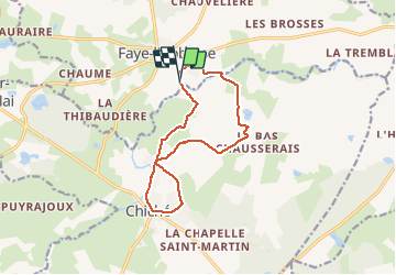
45 km | 52 km-effort Unknown Yes