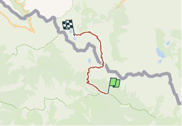
![](/images/other/stat-length.png)
![Trail Walking Saint-Martin-Vésubie - Mercantour Argentera de Salèse au refuge Questa - Photo](https://media.geolcdn.com/t/1900/400/6b2291b9-cc53-4c82-b632-21b9d060ad2d.jpg&format=pjpeg&maxdim=2)
Mercantour Argentera de Salèse au refuge Questa
domi06
User
![Length](/images/other/stat-length.png)
![Max alt](https://static1.geolcdn.com/siteimages/upload/files/1508320355ic_sort_altitude_max_24dp.png)
![Uphill gradient](https://static1.geolcdn.com/siteimages/upload/files/1508320355ic_sort_den_pos_24dp.png)
![Km-Effort](/images/other/stat-length.png)
![Min alt](https://static1.geolcdn.com/siteimages/upload/files/1508320355ic_sort_altitude_min_24dp.png)
![Downhill gradient](https://static1.geolcdn.com/siteimages/upload/files/1508320355ic_sort_den_neg_24dp.png)
![Boucle](https://static1.geolcdn.com/siteimages/upload/files/16400158638029165_repeat_loop_refresh_sync_direction_icon.png)
![Walking](https://static1.geolcdn.com/sitytour/trail-icons/101.png)
6h31
Difficulty : Medium
![Scan this QR Code to open this trail in the SityTrail application](https://capi.geolives.com/qq0zvz2zws4bq2lad0pu/sitytour/trails/2487045/qr.png?size=200)
FREE GPS app for hiking
About
Trail Walking of 16 km to be discovered at Provence-Alpes-Côte d'Azur, Maritime Alps, Saint-Martin-Vésubie. This trail is proposed by domi06.
Description
Départ parking de Salèse (b.434).Monter en direction des vacheries de Salèse et, à proximité des bâtiments, accentuer l’effort sur une section plus pentue. Le sentier continue en fond de vallon jusqu’à la balise 435 au milieu de mélèzes et pins cembros, myrtillais et rodhoraies tapissant le parterre.Arrivé au col de Salèse (b.436), descendre par la piste et prendre à droite (b.268).
Poursuivre sur une ancienne piste caillouteuse et traverser le vallon de Mollières jusqu’à la balise 269 pour bifurquer sur la droite sur un sentier restauré.
L’itinéraire alterne montées et replats jusqu’à Camp Soubran (b.270) offrant en permanence une vue sur le sommet du Caïre Pounchu.
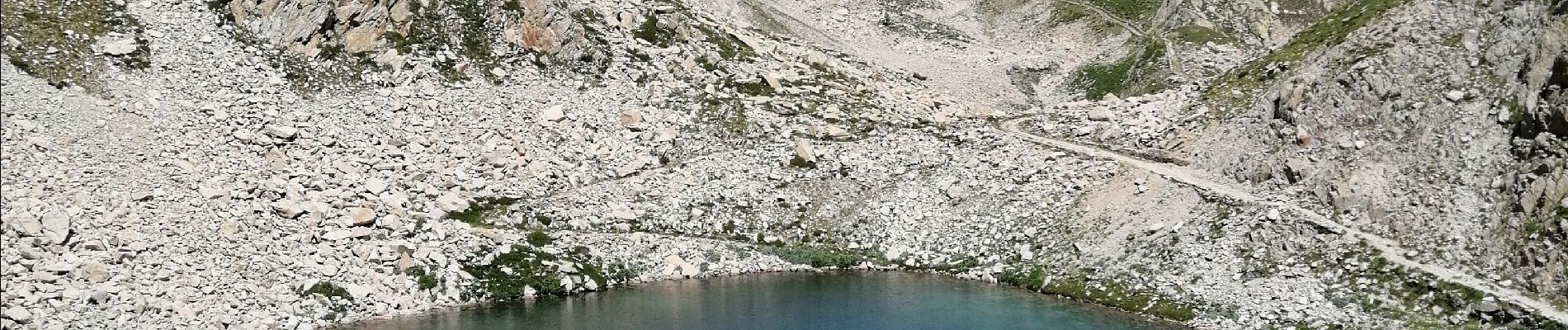
Monter régulièrement en laissant à droite les lacs de Fremamorte jusqu’à atteindre le col homonyme (b.271 -2 615 m), frontière franco-italienne, point d’entrée du Parco Naturalle Alpi Marittime et profiter du panorama à 360°.
Côté italien, au nord-est se dresse l’imposant massif de l’Argentera qui culmine à 3 297 m et à sa gauche le Corno Stella, spot d’escalade très prisé en Italie. Par très beau temps, vous pourrez apercevoir au nord le massif du mont Rose qui s’élève au-delà de la plaine du Pô.
Descendre par le versant italien en lacets rapides et longer tous les lacs de Fremamorte côté est. Passer à proximité d’anciennes casernes et, par une alternance de petites montées et descentes, sur un large sentier sablonneux, se diriger plein nord vers le collet de Valasco laissant sur votre droite le bivouac Guiglia, point de repli en cas de mauvais temps.
Une descente caillouteuse de plus de 300 m de dénivelé offrant sur la gauche une vue sur le vallon des Tablasses, conduit au point inférieur de ce parcours versant italien et se poursuit en direction du refuge Questa.
Le chemin s’élève progressivement, laissant sur la gauche le sentier en direction du Pas de Préfouns. Après un léger replat, quitter le chemin militaire et monter à gauche en direction du refuge Questa. La prochaine intersection offre la possibilité d’accéder au refuge
Positioning
Comments
Trails nearby
![Trail Walking Saint-Martin-Vésubie - Lac de Trécolpas - Photo](https://media.geolcdn.com/t/375/260/ext.jpg?maxdim=2&url=https%3A%2F%2Fservices.sitytrail.com%2FGeolivesWS%2FDownloadMedia.ashx%3FTrailID%3D311062%26Media%3Dfix__20140607150849.jpg)
![Walking Walking](https://static1.geolcdn.com/sitytour/trail-icons/101.png)
Walking
![](/images/other/stat-length.png)
![](https://static1.geolcdn.com/siteimages/upload/files/16400158638029165_repeat_loop_refresh_sync_direction_icon.png)
![Trail Walking Saint-Martin-Vésubie - lacs bessons - Photo](https://media.geolcdn.com/t/375/260/a0e4b44d-1510-4e32-82be-e7e2ee548788.jpg&format=jpg&maxdim=2)
![Walking Walking](https://static1.geolcdn.com/sitytour/trail-icons/101.png)
Walking
![](/images/other/stat-length.png)
![](https://static1.geolcdn.com/siteimages/upload/files/16400158638029165_repeat_loop_refresh_sync_direction_icon.png)
![Trail Walking Saint-Martin-Vésubie - Lac Ne`gre bis - Photo](https://media.geolcdn.com/t/375/260/ext.jpg?maxdim=2&url=https%3A%2F%2Fservices.sitytrail.com%2FGeolivesWS%2FDownloadMedia.ashx%3FTrailID%3D733947%26Media%3D20170416133857.jpg)
![Walking Walking](https://static1.geolcdn.com/sitytour/trail-icons/101.png)
Walking
![](/images/other/stat-length.png)
![](https://static1.geolcdn.com/siteimages/upload/files/16400158638029165_repeat_loop_refresh_sync_direction_icon.png)
![Trail Walking Saint-Martin-Vésubie - Lac Trecolpas - Pas des Ladres - Col de Fenestre - Refuge Cougourde - Photo](https://media.geolcdn.com/t/375/260/541e5768-e182-4791-be6f-0df4a21d2a23.jpg&format=jpg&maxdim=2)
![Walking Walking](https://static1.geolcdn.com/sitytour/trail-icons/101.png)
Walking
![](/images/other/stat-length.png)
![](https://static1.geolcdn.com/siteimages/upload/files/16400158638029165_repeat_loop_refresh_sync_direction_icon.png)
![Trail On foot Saint-Martin-Vésubie - Col de Cerise - Photo](https://media.geolcdn.com/t/375/260/90b1ce11-d155-4ca1-8f15-a1d1ec21efc7.jpeg&format=jpg&maxdim=2)
![On foot On foot](https://static1.geolcdn.com/sitytour/trail-icons/100.png)
On foot
![](/images/other/stat-length.png)
![](https://static1.geolcdn.com/siteimages/upload/files/16400158638029165_repeat_loop_refresh_sync_direction_icon.png)
![Trail On foot Saint-Martin-Vésubie - Circuit des Adus - Photo](https://media.geolcdn.com/t/375/260/1d6d9ad9-9540-40e2-b71d-1e8a26b80478.jpeg&format=jpg&maxdim=2)
![On foot On foot](https://static1.geolcdn.com/sitytour/trail-icons/100.png)
On foot
![](/images/other/stat-length.png)
![](https://static1.geolcdn.com/siteimages/upload/files/16400158638029165_repeat_loop_refresh_sync_direction_icon.png)
![Trail On foot Saint-Martin-Vésubie - Circuit de Trécolpas - Photo](https://media.geolcdn.com/t/375/260/f92e70c7-1f9c-4fa6-ae6b-2c614b3b921c.jpeg&format=jpg&maxdim=2)
![On foot On foot](https://static1.geolcdn.com/sitytour/trail-icons/100.png)
On foot
![](/images/other/stat-length.png)
![](https://static1.geolcdn.com/siteimages/upload/files/16400158638029165_repeat_loop_refresh_sync_direction_icon.png)
![Trail On foot Valdeblore - Lac Nègre - Photo](https://media.geolcdn.com/t/375/260/523722db-6e8e-40d3-b22f-f8992cf9694d.jpeg&format=jpg&maxdim=2)
![On foot On foot](https://static1.geolcdn.com/sitytour/trail-icons/100.png)
On foot
![](/images/other/stat-length.png)
![](https://static1.geolcdn.com/siteimages/upload/files/16400158638029165_repeat_loop_refresh_sync_direction_icon.png)
![Walking Walking](https://static1.geolcdn.com/sitytour/trail-icons/101.png)
Walking
![](/images/other/stat-length.png)
![](https://static1.geolcdn.com/siteimages/upload/files/16400158638029165_repeat_loop_refresh_sync_direction_icon.png)