Trail Walking Le Valtin - Les Rochers des Hirschsteine - Lac Vert - Photo

Les Rochers des Hirschsteine - Lac Vert

 Michel1963
Michel1963

User GUIDE

© OpenStreetMap contributors
Length
Length
14.4 km
Max alt
Max alt
1281 m
Uphill gradient
Uphill gradient
576 m
Km-Effort
Km-Effort  
22 km
Min alt
Min alt
1049 m
Downhill gradient
Downhill gradient
599 m
Boucle
Boucle
Yes
Creation date :
2020-07-21 08:57:29.861
Updated on :
2020-07-21 16:01:39.292

(2 Reviews)

Walking
Walking
5h02
Difficulty : Difficult

Scan this QR Code to open this trail in the SityTrail application

FREE GPS app for hiking

Logo SityTrail SityTrail

IGN / Geographical institutes

Download SityTrail from the App Store Download SityTrail from Google Play

Logo SityTrail SityTrail World

The world is yours!

Download SityTrail from the App Store Download SityTrail from Google Play Download SityTrail on Huawei AppGallery

About

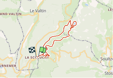
Trail Walking of 14.4 km to be discovered at Grand Est, Vosges, Le Valtin. This trail is proposed by Michel1963.

Description

Splendide parcours aérien vers les Rochers d'où le qualificatif difficile sinon randonnée de difficulté moyenne

Elevation profile

Photos

Positioning

Country:
France
Region :
Grand Est
Department/Province :
Vosges
Municipality :
Le Valtin
Location:
Unknown
Start:(UTM)
352801 ; 5325333 (32U) N.

Comments

Please log in to post a review or rate the element


génial


Trails nearby

Trail Walking Le Valtin - Le Sentier des Roches - Photo
Walking
GUIDE
Michel1963

Walking

Difficult
(2)
Le Valtin, Grand Est, Vosges, France
20 km | 34 km-effort
7h 43min
Yes
Trail Walking Stosswihr - Tour du belvedere avec le passage sur les crêtes  - Photo
Walking
ocepee

Walking

Very easy
(2)
Stosswihr, Grand Est, Haut-Rhin, France
8.5 km | 0 m-effort
2h 28min
Yes
Trail Other activity Soultzeren - Totom 4 lacs - Photo
Other activity
dinozore

Other activity

Medium
(1)
Soultzeren, Grand Est, Haut-Rhin, France
15.6 km | 26 km-effort
4h 37min
Yes
Trail Walking La Bresse - Les 5 lacs autour du Hohneck - Photo
Walking
tiene

Walking

Very difficult
(1)
La Bresse, Grand Est, Vosges, France
21 km | 36 km-effort
7h 21min
Yes
Trail Walking Le Valtin - Les Hirschsteine - Photo
Walking
VacheKiri67

Walking

Difficult
(1)
Le Valtin, Grand Est, Vosges, France
16.1 km | 25 km-effort
6h 28min
Yes
Trail Walking La Bresse - Du Hohneck au Kastelberg par les Spietzkoepfe et le Sentier des Névées - Photo
Walking
tracegps

Walking

Very difficult
(3)
La Bresse, Grand Est, Vosges, France
7.6 km | 13.7 km-effort
3h 30min
Yes
Trail Walking Soultzeren - Tanet-Gazon du faing par lac vert et retour sommet du Tanet - Photo
Walking
ride-in-Elsass

Walking

Medium
(1)
Soultzeren, Grand Est, Haut-Rhin, France
10 km | 15.6 km-effort
4h 24min
Yes
Trail Snowshoes Le Valtin - raquettes  - Photo
Snowshoes
vathi54

Snowshoes

Very easy
(1)
Le Valtin, Grand Est, Vosges, France
6.6 km | 9.4 km-effort
3h 8min
No
Trail Walking Stosswihr - Le cirque glaciaire du Frankenthal - Sentier des Roches -Gps - Photo
Walking
GUIDE
Desrumaux

Walking

Difficult
(3)
Stosswihr, Grand Est, Haut-Rhin, France
9 km | 16.1 km-effort
4h 10min
Yes


Close
My subscriptions