![](/images/other/stat-length.png)
![Trail On foot Saint-Denis - Saint-Denis Marche à pied - Photo](https://media.geolcdn.com/t/1900/400/5f55874a-aabc-4124-b28c-94499a86a1a7.jpg&format=pjpeg&maxdim=2)
Saint-Denis Marche à pied
GilbertLP
User
![Length](/images/other/stat-length.png)
![Max alt](https://static1.geolcdn.com/siteimages/upload/files/1508320355ic_sort_altitude_max_24dp.png)
![Uphill gradient](https://static1.geolcdn.com/siteimages/upload/files/1508320355ic_sort_den_pos_24dp.png)
![Km-Effort](/images/other/stat-length.png)
![Min alt](https://static1.geolcdn.com/siteimages/upload/files/1508320355ic_sort_altitude_min_24dp.png)
![Downhill gradient](https://static1.geolcdn.com/siteimages/upload/files/1508320355ic_sort_den_neg_24dp.png)
![Boucle](https://static1.geolcdn.com/siteimages/upload/files/16400158638029165_repeat_loop_refresh_sync_direction_icon.png)
![On foot](https://static1.geolcdn.com/sitytour/trail-icons/100.png)
--
Difficulty : Very easy
![Scan this QR Code to open this trail in the SityTrail application](https://capi.geolives.com/qq0zvz2zws4bq2lad0pu/sitytour/trails/2484705/qr.png?size=200)
FREE GPS app for hiking
About
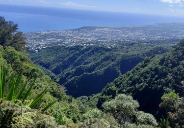
Trail On foot of 5.4 km to be discovered at Réunion, Unknown, Saint-Denis. This trail is proposed by GilbertLP.
Description
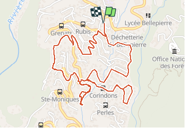
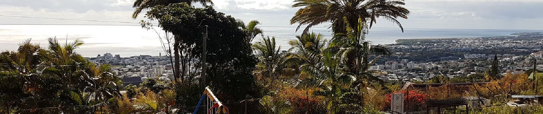
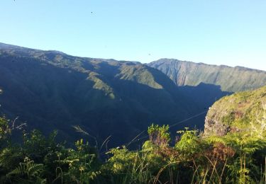
Cette randonnée urbaine dans le quartier de Bellepierre, sorte de balcon surplombant le Chef-lieu de La Réunion, est un bon moment à passer à sillonner à travers les ruelles en pentes plus ou moins fortes, tout en admirant les belles maisons au milieu de grands parcs fleuris.
Le départ et l'arrivée se font auprès de la mairie de quartier. On emprunte quand on peut des marches qui coupent à travers les méandres de l'Allée des Topazes qui monte vers le village du Brûlé. Dès qu'on s'éloigne un peu de cette route départementale, on retrouve le calme paisible au milieu des grands parcs. Quelques chiens montent la garde mais ne s'aventurent que rarement en dehors des cours clôturées.
La boucle est bouclée au bout de deux heures, en marchant à l'allure de sénateur, c'est-à-dire à moins de 3 km/heure. Cela change des randonnées en montagne à La Réunion et l'on se prend à aimer prendre son temps en flânant ainsi, tout en admirant les nombreux points de vue sur la capitale et jusque vers les villes de Sainte Marie ou de Sainte Suzanne.
A consommer sans modération !
Positioning
Comments
Trails nearby
![Trail Mountain bike Saint-Denis - La Réunion - Saint-Denis à Sainte-Suzanne - Photo](https://media.geolcdn.com/t/375/260/ext.jpg?maxdim=2&url=https%3A%2F%2Fservices.sitytrail.com%2FGeolivesWS%2FDownloadMedia.ashx%3FTrailID%3D450603%26Media%3Dfix__20150727121853.jpg)
![Mountain bike Mountain bike](https://static1.geolcdn.com/sitytour/trail-icons/202.png)
Mountain bike
![](/images/other/stat-length.png)
![](https://static1.geolcdn.com/siteimages/upload/files/16400158638029165_repeat_loop_refresh_sync_direction_icon.png)
![Trail Walking Saint-Denis - GRR2 De St Denis à St Philippe (Ile de la Réunion) - Photo](https://media.geolcdn.com/t/375/260/ext.jpg?maxdim=2&url=https%3A%2F%2Fstatic1.geolcdn.com%2Fsiteimages%2Fupload%2Ffiles%2F1553511878bg_sport_marche.png)
![Walking Walking](https://static1.geolcdn.com/sitytour/trail-icons/101.png)
Walking
![](/images/other/stat-length.png)
![](https://static1.geolcdn.com/siteimages/upload/files/16400158638029165_repeat_loop_refresh_sync_direction_icon.png)
![Trail Walking Saint-Denis - Cascade Chaudron - Photo](https://media.geolcdn.com/t/375/260/4c78db83-8a2b-4b90-853f-7dddb71e4da9.jpg&format=jpg&maxdim=2)
![Walking Walking](https://static1.geolcdn.com/sitytour/trail-icons/101.png)
Walking
![](/images/other/stat-length.png)
![](https://static1.geolcdn.com/siteimages/upload/files/16400158638029165_repeat_loop_refresh_sync_direction_icon.png)
![Trail Walking Saint-Denis - La Redoute - Colorado - Photo](https://media.geolcdn.com/t/375/260/ext.jpg?maxdim=2&url=https%3A%2F%2Fservices.sitytrail.com%2FGeolivesWS%2FDownloadMedia.ashx%3FTrailID%3D391451%26Media%3D3343d738-f58a-4ba8-bc74-9d8b4ad4a019.jpg)
![Walking Walking](https://static1.geolcdn.com/sitytour/trail-icons/101.png)
Walking
![](/images/other/stat-length.png)
![](https://static1.geolcdn.com/siteimages/upload/files/16400158638029165_repeat_loop_refresh_sync_direction_icon.png)
![Trail Walking Saint-Denis - La Providence - Le Brulé - Photo](https://media.geolcdn.com/t/375/260/ext.jpg?maxdim=2&url=https%3A%2F%2Fservices.sitytrail.com%2FGeolivesWS%2FDownloadMedia.ashx%3FTrailID%3D389927%26Media%3D4ade833b-81bf-4df6-a49e-76a82fefe393.jpg)
![Walking Walking](https://static1.geolcdn.com/sitytour/trail-icons/101.png)
Walking
![](/images/other/stat-length.png)
![](https://static1.geolcdn.com/siteimages/upload/files/16400158638029165_repeat_loop_refresh_sync_direction_icon.png)
![Trail Mountain bike Saint-Denis - La Réunion - St Denis - Ste Suzanne - Photo](https://media.geolcdn.com/t/375/260/ext.jpg?maxdim=2&url=https%3A%2F%2Fservices.sitytrail.com%2FGeolivesWS%2FDownloadMedia.ashx%3FTrailID%3D263503%26Media%3Dfix__20140405151600.jpg)
![Mountain bike Mountain bike](https://static1.geolcdn.com/sitytour/trail-icons/202.png)
Mountain bike
![](/images/other/stat-length.png)
![](https://static1.geolcdn.com/siteimages/upload/files/16400158638029165_repeat_loop_refresh_sync_direction_icon.png)
![Trail sport Saint-Denis - (J1) - La Providence - Gîte de la Roche Écrite (fait) - Photo](https://media.geolcdn.com/t/375/260/80e2ee2e-035e-4c12-b12e-d6f6e901407d.jpg&format=jpg&maxdim=2)
sport
![](/images/other/stat-length.png)
![](https://static1.geolcdn.com/siteimages/upload/files/16400158638029165_repeat_loop_refresh_sync_direction_icon.png)
![Trail Electric bike Saint-Denis - La Montagne Lycée - Photo](https://media.geolcdn.com/t/375/260/de01112e-98a7-45dd-97f0-007a83d440c7.jpg&format=jpg&maxdim=2)
![Electric bike Electric bike](https://static1.geolcdn.com/sitytour/trail-icons/205.png)
Electric bike
![](/images/other/stat-length.png)
![](https://static1.geolcdn.com/siteimages/upload/files/16400158638029165_repeat_loop_refresh_sync_direction_icon.png)
![Trail Trail Saint-Denis - pic adam/providence - Photo](https://media.geolcdn.com/t/375/260/43f5fa5b-0fe2-43af-9b14-886a7254e393.jpg&format=jpg&maxdim=2)
![Trail Trail](https://static1.geolcdn.com/sitytour/trail-icons/104.png)
Trail
![](/images/other/stat-length.png)
![](https://static1.geolcdn.com/siteimages/upload/files/16400158638029165_repeat_loop_refresh_sync_direction_icon.png)