![](/images/other/stat-length.png)
![Trail Walking Boppard - Al - Mittelrhein klettersteig - Photo](https://media.geolcdn.com/t/1900/400/ext.pjpeg?maxdim=2&url=https%3A%2F%2Fstatic1.geolcdn.com%2Fsiteimages%2Fupload%2Ffiles%2F1553511878bg_sport_marche.png)
Al - Mittelrhein klettersteig
guilmanu
User
![Length](/images/other/stat-length.png)
Length
5.4 km
![Max alt](https://static1.geolcdn.com/siteimages/upload/files/1508320355ic_sort_altitude_max_24dp.png)
Max alt
323 m
![Uphill gradient](https://static1.geolcdn.com/siteimages/upload/files/1508320355ic_sort_den_pos_24dp.png)
Uphill gradient
294 m
![Km-Effort](/images/other/stat-length.png)
Km-Effort
9.3 km
![Min alt](https://static1.geolcdn.com/siteimages/upload/files/1508320355ic_sort_altitude_min_24dp.png)
Min alt
74 m
![Downhill gradient](https://static1.geolcdn.com/siteimages/upload/files/1508320355ic_sort_den_neg_24dp.png)
Downhill gradient
294 m
![Boucle](https://static1.geolcdn.com/siteimages/upload/files/16400158638029165_repeat_loop_refresh_sync_direction_icon.png)
Boucle
Yes
Creation date :
2020-07-20 08:52:57.1
Updated on :
2020-07-25 15:05:06.454
![Walking](https://static1.geolcdn.com/sitytour/trail-icons/101.png)
3h05
Difficulty : Medium
![Scan this QR Code to open this trail in the SityTrail application](https://capi.geolives.com/qq0zvz2zws4bq2lad0pu/sitytour/trails/2484325/qr.png?size=200)
FREE GPS app for hiking
About
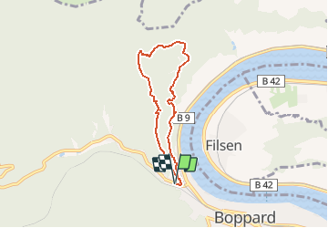
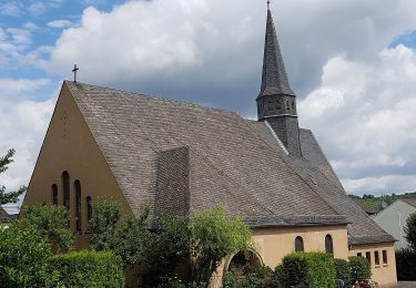
Trail Walking of 5.4 km to be discovered at Rhineland-Palatinate, Rhein-Hunsrück-Kreis, Boppard. This trail is proposed by guilmanu.
Description
Rando assez difficile avec des enfants mais les différents points de vue permettent de découper la progression. Il est possible de faire une partie de la montée en via ferata.
Le descriptif de la rando est disponible dans les offices de tourisme.
Positioning
Country:
Germany
Region :
Rhineland-Palatinate
Department/Province :
Rhein-Hunsrück-Kreis
Municipality :
Boppard
Location:
Unknown
Start:(Dec)
Start:(UTM)
398412 ; 5565772 (32U) N.
Comments
Trails nearby
![Trail On foot Osterspai - Rheinsteig-Zuweg Osterspai - Photo](https://media.geolcdn.com/t/375/260/f6f75fe7-a4a6-44b5-af45-6efbc94565f7.jpeg&format=jpg&maxdim=2)
![On foot On foot](https://static1.geolcdn.com/sitytour/trail-icons/100.png)
Rheinsteig-Zuweg Osterspai
On foot
Easy
Osterspai,
Rhineland-Palatinate,
Rhein-Lahn-Kreis,
Germany
![](/images/other/stat-length.png)
3.6 km | 4.4 km-effort
59min
![](https://static1.geolcdn.com/siteimages/upload/files/16400158638029165_repeat_loop_refresh_sync_direction_icon.png)
No
![Trail On foot Braubach - Rundwanderweg Burgenweg Braubach - Photo](https://media.geolcdn.com/t/375/260/e6fd4102-f5e1-435b-bcfc-936c935ad7a7.jpeg&format=jpg&maxdim=2)
![On foot On foot](https://static1.geolcdn.com/sitytour/trail-icons/100.png)
Rundwanderweg Burgenweg Braubach
On foot
Easy
Braubach,
Rhineland-Palatinate,
Rhein-Lahn-Kreis,
Germany
![](/images/other/stat-length.png)
4.4 km | 6.7 km-effort
1h 31min
![](https://static1.geolcdn.com/siteimages/upload/files/16400158638029165_repeat_loop_refresh_sync_direction_icon.png)
Yes
![Trail On foot Boppard - Traumschleife Marienberg - Photo](https://media.geolcdn.com/t/375/260/4ce89ddc-05da-4825-84b5-a9dc0e82caf7.jpeg&format=jpg&maxdim=2)
![On foot On foot](https://static1.geolcdn.com/sitytour/trail-icons/100.png)
Traumschleife Marienberg
On foot
Easy
Boppard,
Rhineland-Palatinate,
Rhein-Hunsrück-Kreis,
Germany
![](/images/other/stat-length.png)
4 km | 5.5 km-effort
1h 15min
![](https://static1.geolcdn.com/siteimages/upload/files/16400158638029165_repeat_loop_refresh_sync_direction_icon.png)
No
![Trail On foot Rhens - Traumpfad Wolfsdelle - Photo](https://media.geolcdn.com/t/375/260/72c57967-8508-4cce-9d69-5896d62aaee1.jpeg&format=jpg&maxdim=2)
![On foot On foot](https://static1.geolcdn.com/sitytour/trail-icons/100.png)
Traumpfad Wolfsdelle
On foot
Easy
Rhens,
Rhineland-Palatinate,
Landkreis Mayen-Koblenz,
Germany
![](/images/other/stat-length.png)
10.3 km | 14.7 km-effort
3h 20min
![](https://static1.geolcdn.com/siteimages/upload/files/16400158638029165_repeat_loop_refresh_sync_direction_icon.png)
Yes
![Trail On foot Brey - Traumpfade](https://media.geolcdn.com/t/375/260/70b625c3-4e9d-4394-93a9-ed68b2bb0375.jpeg&format=jpg&maxdim=2)
![On foot On foot](https://static1.geolcdn.com/sitytour/trail-icons/100.png)
Traumpfade "Rheingoldbogen"
On foot
Easy
Brey,
Rhineland-Palatinate,
Landkreis Mayen-Koblenz,
Germany
![](/images/other/stat-length.png)
12.6 km | 16.9 km-effort
3h 50min
![](https://static1.geolcdn.com/siteimages/upload/files/16400158638029165_repeat_loop_refresh_sync_direction_icon.png)
Yes
![Trail On foot Boppard - Schöneckschleife - Photo](https://media.geolcdn.com/t/375/260/ext.jpg?maxdim=2&url=https%3A%2F%2Fstatic1.geolcdn.com%2Fsiteimages%2Fupload%2Ffiles%2F1545311037marcheuse_200dpi.jpg)
![On foot On foot](https://static1.geolcdn.com/sitytour/trail-icons/100.png)
Schöneckschleife
On foot
Easy
Boppard,
Rhineland-Palatinate,
Rhein-Hunsrück-Kreis,
Germany
![](/images/other/stat-length.png)
6.4 km | 8.7 km-effort
1h 59min
![](https://static1.geolcdn.com/siteimages/upload/files/16400158638029165_repeat_loop_refresh_sync_direction_icon.png)
Yes
![Trail On foot Boppard - Traumschleife Fünfseenblick - Photo](https://media.geolcdn.com/t/375/260/ext.jpg?maxdim=2&url=https%3A%2F%2Fstatic1.geolcdn.com%2Fsiteimages%2Fupload%2Ffiles%2F1545311037marcheuse_200dpi.jpg)
![On foot On foot](https://static1.geolcdn.com/sitytour/trail-icons/100.png)
Traumschleife Fünfseenblick
On foot
Easy
Boppard,
Rhineland-Palatinate,
Rhein-Hunsrück-Kreis,
Germany
![](/images/other/stat-length.png)
10.9 km | 16.7 km-effort
3h 47min
![](https://static1.geolcdn.com/siteimages/upload/files/16400158638029165_repeat_loop_refresh_sync_direction_icon.png)
Yes
![Trail On foot Kamp-Bornhofen - Rheinsteig [Kramp-Bornhofen - Kestert] - Photo](https://media.geolcdn.com/t/375/260/ext.jpg?maxdim=2&url=https%3A%2F%2Fstatic1.geolcdn.com%2Fsiteimages%2Fupload%2Ffiles%2F1545311037marcheuse_200dpi.jpg)
![On foot On foot](https://static1.geolcdn.com/sitytour/trail-icons/100.png)
Rheinsteig [Kramp-Bornhofen - Kestert]
On foot
Easy
Kamp-Bornhofen,
Rhineland-Palatinate,
Rhein-Lahn-Kreis,
Germany
![](/images/other/stat-length.png)
10.3 km | 15 km-effort
3h 24min
![](https://static1.geolcdn.com/siteimages/upload/files/16400158638029165_repeat_loop_refresh_sync_direction_icon.png)
No
![Trail Walking Brey - w-duitsland-rheingoldbogen - Photo](https://media.geolcdn.com/t/375/260/ext.jpg?maxdim=2&url=https%3A%2F%2Fstatic1.geolcdn.com%2Fsiteimages%2Fupload%2Ffiles%2F1553511878bg_sport_marche.png)
![Walking Walking](https://static1.geolcdn.com/sitytour/trail-icons/101.png)
w-duitsland-rheingoldbogen
Walking
Very easy
Brey,
Rhineland-Palatinate,
Landkreis Mayen-Koblenz,
Germany
![](/images/other/stat-length.png)
12.4 km | 16.8 km-effort
Unknown
![](https://static1.geolcdn.com/siteimages/upload/files/16400158638029165_repeat_loop_refresh_sync_direction_icon.png)
Yes