Trail Walking Kastellaun - Al - Kastellaun - Photo
 guilmanu
guilmanu

User

© OpenStreetMap contributors
Length
Length
2.1 km
Max alt
Max alt
427 m
Uphill gradient
Uphill gradient
20 m
Km-Effort
Km-Effort  
2.4 km
Min alt
Min alt
408 m
Downhill gradient
Downhill gradient
21 m
Boucle
Boucle
Yes
Creation date :
2020-07-18 13:23:11.202
Updated on :
2020-07-25 14:57:32.396

(0 Reviews)

Walking
Walking
1h19
Difficulty : Very easy

Scan this QR Code to open this trail in the SityTrail application

FREE GPS app for hiking

Logo SityTrail SityTrail

IGN / Geographical institutes

Download SityTrail from the App Store Download SityTrail from Google Play

Logo SityTrail SityTrail World

The world is yours!

Download SityTrail from the App Store Download SityTrail from Google Play Download SityTrail on Huawei AppGallery

About

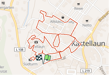
Trail Walking of 2.1 km to be discovered at Rhineland-Palatinate, Rhein-Hunsrück-Kreis, Kastellaun. This trail is proposed by guilmanu.

Description

Visite de la vielle ville de Kastellaun

Elevation profile

Positioning

Country:
Germany
Region :
Rhineland-Palatinate
Department/Province :
Rhein-Hunsrück-Kreis
Municipality :
Kastellaun
Location:
Unknown
Start:(UTM)
388298 ; 5547622 (32U) N.

Trails nearby

Trail On foot Zilshausen - Traumschleife Dünnbachpfad - Photo
On foot
GUIDE+

On foot

Easy
Zilshausen, Rhineland-Palatinate, Rhein-Hunsrück-Kreis, Germany
10.8 km | 15 km-effort
3h 24min
Yes
Trail On foot Laubach - Traumschleife Klingelfloß - Photo
On foot
GUIDE+

On foot

Easy
Laubach, Rhineland-Palatinate, Rhein-Hunsrück-Kreis, Germany
7.8 km | 9.7 km-effort
2h 12min
Yes
Trail Walking Kastellaun - Al - burgstadt-pfad (sentier de la ville fortifiée) - Photo
Walking
guilmanu

Walking

Easy
Kastellaun, Rhineland-Palatinate, Rhein-Hunsrück-Kreis, Germany
7.8 km | 9.3 km-effort
4h 7min
Yes


Close
My subscriptions