![](/images/other/stat-length.png)
![Trail Walking Sainte-Croix - Aiguilles de baulmes - mont de baulmes par la Gitta - Photo](https://media.geolcdn.com/t/1900/400/ext.pjpeg?maxdim=2&url=https%3A%2F%2Fstatic1.geolcdn.com%2Fsiteimages%2Fupload%2Ffiles%2F1553511878bg_sport_marche.png)
Aiguilles de baulmes - mont de baulmes par la Gitta
cyrghe
User
![Length](/images/other/stat-length.png)
![Max alt](https://static1.geolcdn.com/siteimages/upload/files/1508320355ic_sort_altitude_max_24dp.png)
![Uphill gradient](https://static1.geolcdn.com/siteimages/upload/files/1508320355ic_sort_den_pos_24dp.png)
![Km-Effort](/images/other/stat-length.png)
![Min alt](https://static1.geolcdn.com/siteimages/upload/files/1508320355ic_sort_altitude_min_24dp.png)
![Downhill gradient](https://static1.geolcdn.com/siteimages/upload/files/1508320355ic_sort_den_neg_24dp.png)
![Boucle](https://static1.geolcdn.com/siteimages/upload/files/16400158638029165_repeat_loop_refresh_sync_direction_icon.png)
![Walking](https://static1.geolcdn.com/sitytour/trail-icons/101.png)
3h52
Difficulty : Very difficult
![Scan this QR Code to open this trail in the SityTrail application](https://capi.geolives.com/qq0zvz2zws4bq2lad0pu/sitytour/trails/2482168/qr.png?size=200)
FREE GPS app for hiking
About
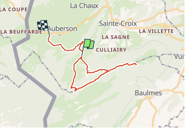
Trail Walking of 13.9 km to be discovered at Vaud, District du Jura-Nord vaudois, Sainte-Croix. This trail is proposed by cyrghe.
Description
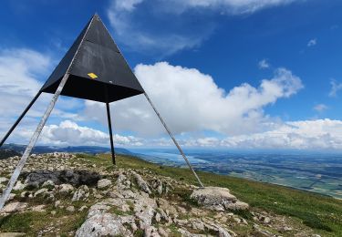
Superbes paysages sur la crête- Nous avons tourné un peu tôt sur les aiguilles de baulmes. Poursuivre un peu sur la petite route en direction du Mont de Baulmes pour éviter de revenir sur nos traces. Cave noire, petite grotte sans intérêt, à ne surtout pas faire avec des enfants, très dangereux. Environ 300 m de dénivelés mais des parties assez raides, à la montée comme à la descente
Positioning
Comments
Trails nearby
![Trail On foot Sainte-Croix - La Gittaz-Col de l'Aigullon - Photo](https://media.geolcdn.com/t/375/260/6946b4e0-6068-4cfa-bbe6-24c55651ec09.jpeg&format=jpg&maxdim=2)
![On foot On foot](https://static1.geolcdn.com/sitytour/trail-icons/100.png)
On foot
![](/images/other/stat-length.png)
![](https://static1.geolcdn.com/siteimages/upload/files/16400158638029165_repeat_loop_refresh_sync_direction_icon.png)
![Trail On foot Sainte-Croix - Sainte Croix-La Gittaz - Photo](https://media.geolcdn.com/t/375/260/7c0dcc60-9777-42cd-b5f3-05d60f03159f.jpeg&format=jpg&maxdim=2)
![On foot On foot](https://static1.geolcdn.com/sitytour/trail-icons/100.png)
On foot
![](/images/other/stat-length.png)
![](https://static1.geolcdn.com/siteimages/upload/files/16400158638029165_repeat_loop_refresh_sync_direction_icon.png)
![Trail On foot Sainte-Croix - Chemin de la Gare - Photo](https://media.geolcdn.com/t/375/260/1c01c3b8-df2a-4423-9b92-ab96556853c0.jpeg&format=jpg&maxdim=2)
![On foot On foot](https://static1.geolcdn.com/sitytour/trail-icons/100.png)
On foot
![](/images/other/stat-length.png)
![](https://static1.geolcdn.com/siteimages/upload/files/16400158638029165_repeat_loop_refresh_sync_direction_icon.png)
![Trail Walking Jougne - Aiguilles de Baulmes - Suisse - Photo](https://media.geolcdn.com/t/375/260/ext.jpg?maxdim=2&url=https%3A%2F%2Fstatic1.geolcdn.com%2Fsiteimages%2Fupload%2Ffiles%2F1553511878bg_sport_marche.png)
![Walking Walking](https://static1.geolcdn.com/sitytour/trail-icons/101.png)
Walking
![](/images/other/stat-length.png)
![](https://static1.geolcdn.com/siteimages/upload/files/16400158638029165_repeat_loop_refresh_sync_direction_icon.png)
![Trail Cross-country skiing Les Fourgs - Piste du Voirnon - Photo](https://media.geolcdn.com/t/375/260/4d46f533-833e-4cab-9d13-d16310de5eba.jpg&format=jpg&maxdim=2)
![Cross-country skiing Cross-country skiing](https://static1.geolcdn.com/sitytour/trail-icons/502.png)
Cross-country skiing
![](/images/other/stat-length.png)
![](https://static1.geolcdn.com/siteimages/upload/files/16400158638029165_repeat_loop_refresh_sync_direction_icon.png)
![Trail On foot Les Fourgs - Le Sentier des Bornes - Photo](https://media.geolcdn.com/t/375/260/4777e0b5-35d9-430b-b18b-01a7bbd1a8dc.jpeg&format=jpg&maxdim=2)
![On foot On foot](https://static1.geolcdn.com/sitytour/trail-icons/100.png)
On foot
![](/images/other/stat-length.png)
![](https://static1.geolcdn.com/siteimages/upload/files/16400158638029165_repeat_loop_refresh_sync_direction_icon.png)
![Trail Walking Sainte-Croix - le Chasseron par les avattes - Photo](https://media.geolcdn.com/t/375/260/ext.jpg?maxdim=2&url=https%3A%2F%2Fservices.sitytrail.com%2FGeolivesWS%2FDownloadMedia.ashx%3FTrailID%3D966325%26Media%3Dfix__20180507162134.jpg)
![Walking Walking](https://static1.geolcdn.com/sitytour/trail-icons/101.png)
Walking
![](/images/other/stat-length.png)
![](https://static1.geolcdn.com/siteimages/upload/files/16400158638029165_repeat_loop_refresh_sync_direction_icon.png)
![Trail Walking Jougne - aiguilles de Baulmes et retour Suchet - Photo](https://media.geolcdn.com/t/375/260/c17e4977-34fe-43ba-93d4-0a17ab33486a.jpg&format=jpg&maxdim=2)
![Walking Walking](https://static1.geolcdn.com/sitytour/trail-icons/101.png)
Walking
![](/images/other/stat-length.png)
![](https://static1.geolcdn.com/siteimages/upload/files/16400158638029165_repeat_loop_refresh_sync_direction_icon.png)
![Trail Snowshoes Sainte-Croix - Col des Etroits Le Chasseron CAF - Photo](https://media.geolcdn.com/t/375/260/73c05fda-b10e-4eb7-8c51-21af8620a72d.jpg&format=jpg&maxdim=2)
![Snowshoes Snowshoes](https://static1.geolcdn.com/sitytour/trail-icons/504.png)
Snowshoes
![](/images/other/stat-length.png)
![](https://static1.geolcdn.com/siteimages/upload/files/16400158638029165_repeat_loop_refresh_sync_direction_icon.png)