![](/images/other/stat-length.png)
![Trail Electric bike Domène - 2020-07-17_19h09m10_SityTrail - 2478820 - domene-biviers-manival - Photo](https://media.geolcdn.com/t/1900/400/ext.pjpeg?maxdim=2&url=https%3A%2F%2Fstatic1.geolcdn.com%2Fsiteimages%2Fupload%2Ffiles%2F1524743154velo.jpg)
2020-07-17_19h09m10_SityTrail - 2478820 - domene-biviers-manival
Fx Langloys
User
![Length](/images/other/stat-length.png)
Length
36 km
![Max alt](https://static1.geolcdn.com/siteimages/upload/files/1508320355ic_sort_altitude_max_24dp.png)
Max alt
505 m
![Uphill gradient](https://static1.geolcdn.com/siteimages/upload/files/1508320355ic_sort_den_pos_24dp.png)
Uphill gradient
626 m
![Km-Effort](/images/other/stat-length.png)
Km-Effort
45 km
![Min alt](https://static1.geolcdn.com/siteimages/upload/files/1508320355ic_sort_altitude_min_24dp.png)
Min alt
208 m
![Downhill gradient](https://static1.geolcdn.com/siteimages/upload/files/1508320355ic_sort_den_neg_24dp.png)
Downhill gradient
624 m
![Boucle](https://static1.geolcdn.com/siteimages/upload/files/16400158638029165_repeat_loop_refresh_sync_direction_icon.png)
Boucle
No
Creation date :
2020-07-17 17:09:11.419
Updated on :
2020-08-27 09:16:54.729
![Electric bike](https://static1.geolcdn.com/sitytour/trail-icons/205.png)
--
Difficulty : Very easy
![Scan this QR Code to open this trail in the SityTrail application](https://capi.geolives.com/qq0zvz2zws4bq2lad0pu/sitytour/trails/2479543/qr.png?size=200)
FREE GPS app for hiking
About
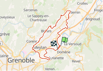
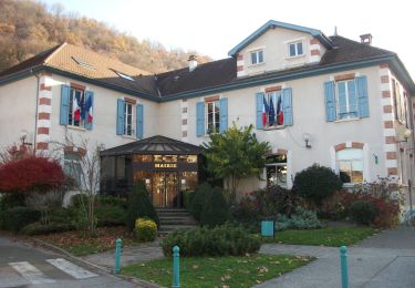
Trail Electric bike of 36 km to be discovered at Auvergne-Rhône-Alpes, Isère, Domène. This trail is proposed by Fx Langloys.
Description
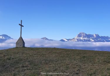
30mn de plat pour s'échauffer et ensuite biviers et saint Ismier le haut par des petits chemins goudronnés, passage par le Manival et chemins en terre sur St Nazaire et Bernin. Randonnée facile mais bonne dépense d'énergie.
Positioning
Country:
France
Region :
Auvergne-Rhône-Alpes
Department/Province :
Isère
Municipality :
Domène
Location:
Unknown
Start:(Dec)
Start:(UTM)
722352 ; 5010331 (31T) N.
Comments
Trails nearby
![Trail On foot La Combe-de-Lancey - Chemin de Découverte (boucle Basse) - Photo](https://media.geolcdn.com/t/375/260/6915f95f-b034-4e84-88aa-9ed85af7f443.jpeg&format=jpg&maxdim=2)
![On foot On foot](https://static1.geolcdn.com/sitytour/trail-icons/100.png)
Chemin de Découverte (boucle Basse)
On foot
Easy
La Combe-de-Lancey,
Auvergne-Rhône-Alpes,
Isère,
France
![](/images/other/stat-length.png)
3.5 km | 5.1 km-effort
1h 9min
![](https://static1.geolcdn.com/siteimages/upload/files/16400158638029165_repeat_loop_refresh_sync_direction_icon.png)
Yes
![Trail On foot La Combe-de-Lancey - Chemin de Découverte (boucle Haute) - Photo](https://media.geolcdn.com/t/375/260/6a0cb0d1-93da-4068-99ad-9a549161cacf.jpeg&format=jpg&maxdim=2)
![On foot On foot](https://static1.geolcdn.com/sitytour/trail-icons/100.png)
Chemin de Découverte (boucle Haute)
On foot
Easy
La Combe-de-Lancey,
Auvergne-Rhône-Alpes,
Isère,
France
![](/images/other/stat-length.png)
3.5 km | 5.4 km-effort
1h 13min
![](https://static1.geolcdn.com/siteimages/upload/files/16400158638029165_repeat_loop_refresh_sync_direction_icon.png)
Yes
![Trail On foot Domène - Domène à Murianette, par les rives de l'Isère - Photo](https://media.geolcdn.com/t/375/260/f00f3b3d-abcc-47f4-9cc6-e5ee52a8ddd2.jpeg&format=jpg&maxdim=2)
![On foot On foot](https://static1.geolcdn.com/sitytour/trail-icons/100.png)
Domène à Murianette, par les rives de l'Isère
On foot
Easy
Domène,
Auvergne-Rhône-Alpes,
Isère,
France
![](/images/other/stat-length.png)
6.4 km | 7 km-effort
1h 35min
![](https://static1.geolcdn.com/siteimages/upload/files/16400158638029165_repeat_loop_refresh_sync_direction_icon.png)
No
![Trail On foot Domène - Circuit de Beauregard - Photo](https://media.geolcdn.com/t/375/260/c0d86b6a-ec41-4f3c-879d-1fb6f4151878.jpeg&format=jpg&maxdim=2)
![On foot On foot](https://static1.geolcdn.com/sitytour/trail-icons/100.png)
Circuit de Beauregard
On foot
Easy
Domène,
Auvergne-Rhône-Alpes,
Isère,
France
![](/images/other/stat-length.png)
3.6 km | 7 km-effort
1h 35min
![](https://static1.geolcdn.com/siteimages/upload/files/16400158638029165_repeat_loop_refresh_sync_direction_icon.png)
Yes
![Trail On foot Domène - Circuit de la Monta - Photo](https://media.geolcdn.com/t/375/260/8f502881-e98d-4929-b19b-6c8e9cb279e5.jpeg&format=jpg&maxdim=2)
![On foot On foot](https://static1.geolcdn.com/sitytour/trail-icons/100.png)
Circuit de la Monta
On foot
Easy
Domène,
Auvergne-Rhône-Alpes,
Isère,
France
![](/images/other/stat-length.png)
9.9 km | 15.4 km-effort
3h 29min
![](https://static1.geolcdn.com/siteimages/upload/files/16400158638029165_repeat_loop_refresh_sync_direction_icon.png)
Yes
![Trail On foot Saint-Jean-le-Vieux - La Tour de Revel (par le Mollard) - Photo](https://media.geolcdn.com/t/375/260/9b2599de-7f79-405c-8210-bdfecfa7c849.jpeg&format=jpg&maxdim=2)
![On foot On foot](https://static1.geolcdn.com/sitytour/trail-icons/100.png)
La Tour de Revel (par le Mollard)
On foot
Easy
Saint-Jean-le-Vieux,
Auvergne-Rhône-Alpes,
Isère,
France
![](/images/other/stat-length.png)
7.9 km | 13.4 km-effort
3h 2min
![](https://static1.geolcdn.com/siteimages/upload/files/16400158638029165_repeat_loop_refresh_sync_direction_icon.png)
No
![Trail On foot Gières - De Gières au col du Gourlu - Photo](https://media.geolcdn.com/t/375/260/b782ea79-2f14-452c-9af6-76dad2fec664.jpeg&format=jpg&maxdim=2)
![On foot On foot](https://static1.geolcdn.com/sitytour/trail-icons/100.png)
De Gières au col du Gourlu
On foot
Easy
Gières,
Auvergne-Rhône-Alpes,
Isère,
France
![](/images/other/stat-length.png)
6.2 km | 10.5 km-effort
2h 22min
![](https://static1.geolcdn.com/siteimages/upload/files/16400158638029165_repeat_loop_refresh_sync_direction_icon.png)
No
![Trail Mountain bike Domène - Domène, grande boucle : la Bourjat - bois de l'envers - grands bois - Photo](https://media.geolcdn.com/t/375/260/ext.jpg?maxdim=2&url=https%3A%2F%2Fstatic1.geolcdn.com%2Fsiteimages%2Fupload%2Ffiles%2F1524743154velo.jpg)
![Mountain bike Mountain bike](https://static1.geolcdn.com/sitytour/trail-icons/202.png)
Domène, grande boucle : la Bourjat - bois de l'envers - grands bois
Mountain bike
Medium
(1)
Domène,
Auvergne-Rhône-Alpes,
Isère,
France
![](/images/other/stat-length.png)
10.9 km | 17.5 km-effort
1h 5min
![](https://static1.geolcdn.com/siteimages/upload/files/16400158638029165_repeat_loop_refresh_sync_direction_icon.png)
Yes
![Trail Walking Le Versoud - Le Versoud - La Poya - Croix de Revollat - Photo](https://media.geolcdn.com/t/375/260/aff89fc8-99ff-4cd9-8804-5cacdc6ef42f.jpg&format=jpg&maxdim=2)
![Walking Walking](https://static1.geolcdn.com/sitytour/trail-icons/101.png)
Le Versoud - La Poya - Croix de Revollat
Walking
Difficult
Le Versoud,
Auvergne-Rhône-Alpes,
Isère,
France
![](/images/other/stat-length.png)
18.7 km | 31 km-effort
4h 52min
![](https://static1.geolcdn.com/siteimages/upload/files/16400158638029165_repeat_loop_refresh_sync_direction_icon.png)
Yes