Eparcy SityTrail > Trails > Outdoor > France > Hauts-de-France > Aisne > Éparcy SityTrail > Trails > Outdoor > France > Hauts-de-France > Aisne > Éparcy Eparcy Michel Tondus User 3D © OpenStreetMap contributors Length 5.5 km Max alt 187 m Uphill gradient 80 m Km-Effort 6.5 km Min alt 149 m Downhill gradient 78 m Boucle Yes Creation date : 2020-07-14 05:09:20.0 Updated on : 2020-07-15 15:42:19.464 (0 Reviews) Running 39m Difficulty : Unknown FREE GPS app for hiking SityTrail IGN / Geographical institutes SityTrail World The world is yours! About Trail Running of 5.5 km to be discovered at Hauts-de-France, Aisne, Éparcy. This trail is proposed by Michel Tondus. Description Petite sortie matinale Legends | More details (PDF) Elevation profile Legends > 15% 15% - 10% 10% - 5% flat 5% - 10% 10% - 15% 15% - 30% > 30% Photos Positioning Country: France Region : Hauts-de-France Department/Province : Aisne Municipality : Éparcy Location: Unknown Start:(Dec) 49.872916 / 4.059556 Start:(UTM) 576135 ; 5525039 (31U) N. Comments Please log in to post a review or rate the element Trails nearby destras Véloroute3 de Hirson à Maubeuge Cycle Medium Hirson, Hauts-de-France, Aisne, France 
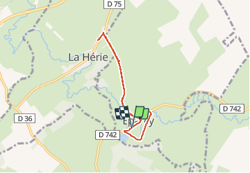
66 km | 76 km-effort 3h 10min No ADL339 91.342 Hirson - Cascade de Blangy Walking Medium Hirson, Hauts-de-France, Aisne, France 16.1 km | 19 km-effort 4h 18min Yes