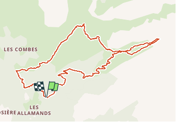
![](/images/other/stat-length.png)
![Trail Walking Samoëns - Les Allamands lac des Verdets - Photo](https://media.geolcdn.com/t/1900/400/21a0ab15-cd67-4aab-a033-05ddeaa63652.jpg&format=pjpeg&maxdim=2)
Les Allamands lac des Verdets
reneperrin
User
![Length](/images/other/stat-length.png)
![Max alt](https://static1.geolcdn.com/siteimages/upload/files/1508320355ic_sort_altitude_max_24dp.png)
![Uphill gradient](https://static1.geolcdn.com/siteimages/upload/files/1508320355ic_sort_den_pos_24dp.png)
![Km-Effort](/images/other/stat-length.png)
![Min alt](https://static1.geolcdn.com/siteimages/upload/files/1508320355ic_sort_altitude_min_24dp.png)
![Downhill gradient](https://static1.geolcdn.com/siteimages/upload/files/1508320355ic_sort_den_neg_24dp.png)
![Boucle](https://static1.geolcdn.com/siteimages/upload/files/16400158638029165_repeat_loop_refresh_sync_direction_icon.png)
![Walking](https://static1.geolcdn.com/sitytour/trail-icons/101.png)
4h17
Difficulty : Easy
![Scan this QR Code to open this trail in the SityTrail application](https://capi.geolives.com/qq0zvz2zws4bq2lad0pu/sitytour/trails/2475592/qr.png?size=200)
FREE GPS app for hiking
About
Trail Walking of 12.7 km to be discovered at Auvergne-Rhône-Alpes, Upper Savoy, Samoëns. This trail is proposed by reneperrin.
Description
Départ du parking au-dessus des Allamands, en forêt puis montée à travers les alpages jusqu’au refuge de Bostan, ensuite on continue la montée jusqu’au lac des Verdets qui est à sec actuellement (14/07/2020). Le retour peut se faire par un sentier qui passe plus dans le fond du vallon. Au retour, après le refuge de Bostan on prend la direction du refuge de la Golèze où passe le GR5. Le retour vers le parking se fait par le GR5 qui suit une large piste semi-carrossable.
Positioning
Comments
Trails nearby
![Trail Walking Samoëns - Samoens . gorges des tines - retour - Photo](https://media.geolcdn.com/t/375/260/9ca94656-f570-41a8-90f6-cc5f5e98fa82.jpg&format=jpg&maxdim=2)
![Walking Walking](https://static1.geolcdn.com/sitytour/trail-icons/101.png)
Walking
![](/images/other/stat-length.png)
![](https://static1.geolcdn.com/siteimages/upload/files/16400158638029165_repeat_loop_refresh_sync_direction_icon.png)
![Trail Walking Samoëns - La Tête de Bostan - Photo](https://media.geolcdn.com/t/375/260/ext.jpg?maxdim=2&url=https%3A%2F%2Fstatic1.geolcdn.com%2Fsiteimages%2Fupload%2Ffiles%2F1553511878bg_sport_marche.png)
![Walking Walking](https://static1.geolcdn.com/sitytour/trail-icons/101.png)
Walking
![](/images/other/stat-length.png)
![](https://static1.geolcdn.com/siteimages/upload/files/16400158638029165_repeat_loop_refresh_sync_direction_icon.png)
![Trail Touring skiing Samoëns - 2025-01-30 Sortie Ski de Rando Col de la Golese - Photo](https://media.geolcdn.com/t/375/260/5172d417-9875-43d9-89bb-031c8ee85781.jpg&format=jpg&maxdim=2)
![Touring skiing Touring skiing](https://static1.geolcdn.com/sitytour/trail-icons/503.png)
Touring skiing
![](/images/other/stat-length.png)
![](https://static1.geolcdn.com/siteimages/upload/files/16400158638029165_repeat_loop_refresh_sync_direction_icon.png)
![Trail Walking Verchaix - col de joux plane - Photo](https://media.geolcdn.com/t/375/260/f5f22de2-b8d8-4ec7-857b-352656491634.jpg&format=jpg&maxdim=2)
![Walking Walking](https://static1.geolcdn.com/sitytour/trail-icons/101.png)
Walking
![](/images/other/stat-length.png)
![](https://static1.geolcdn.com/siteimages/upload/files/16400158638029165_repeat_loop_refresh_sync_direction_icon.png)
![Trail Walking Samoëns - La tête de Bostan - Photo](https://media.geolcdn.com/t/375/260/c42830f7-a262-4abd-8f00-d269896222b2.jpg&format=jpg&maxdim=2)
![Walking Walking](https://static1.geolcdn.com/sitytour/trail-icons/101.png)
Walking
![](/images/other/stat-length.png)
![](https://static1.geolcdn.com/siteimages/upload/files/16400158638029165_repeat_loop_refresh_sync_direction_icon.png)
![Trail Walking Samoëns - SAMOENS: LES ALLAMANDS - BOSTAN (CHALETS - REFUGE - COL - TETE) - GOLESE - Photo](https://media.geolcdn.com/t/375/260/c5ba1cee-0408-4163-a2ab-ac65d7121802.jpg&format=jpg&maxdim=2)
![Walking Walking](https://static1.geolcdn.com/sitytour/trail-icons/101.png)
Walking
![](/images/other/stat-length.png)
![](https://static1.geolcdn.com/siteimages/upload/files/16400158638029165_repeat_loop_refresh_sync_direction_icon.png)
![Trail Walking Samoëns - les chalets du Bémont et cascade du Nant d Ant - Photo](https://media.geolcdn.com/t/375/260/70ac3ce4-77a9-4b40-b9e3-5a1ff6333052.jpg&format=jpg&maxdim=2)
![Walking Walking](https://static1.geolcdn.com/sitytour/trail-icons/101.png)
Walking
![](/images/other/stat-length.png)
![](https://static1.geolcdn.com/siteimages/upload/files/16400158638029165_repeat_loop_refresh_sync_direction_icon.png)
![Trail Walking Samoëns - SAMOENS: LAC DES CHAMBRES - Photo](https://media.geolcdn.com/t/375/260/cd8f3e5f-51d1-4c9a-9456-e0bd19938b89.jpg&format=jpg&maxdim=2)
![Walking Walking](https://static1.geolcdn.com/sitytour/trail-icons/101.png)
Walking
![](/images/other/stat-length.png)
![](https://static1.geolcdn.com/siteimages/upload/files/16400158638029165_repeat_loop_refresh_sync_direction_icon.png)
![Trail Walking Samoëns - SAMOENS: BOSTAN - GOLESE - Photo](https://media.geolcdn.com/t/375/260/6d485ceb-76c9-494d-ab79-683ad7388c0a.jpg&format=jpg&maxdim=2)
![Walking Walking](https://static1.geolcdn.com/sitytour/trail-icons/101.png)
Walking
![](/images/other/stat-length.png)
![](https://static1.geolcdn.com/siteimages/upload/files/16400158638029165_repeat_loop_refresh_sync_direction_icon.png)
merci