![](/images/other/stat-length.png)
![Trail Car Les Hauts-de-Chée - Colombey les 2 églises et le lac du Der depuis Les Hauts de Chée - Photo](https://media.geolcdn.com/t/1900/400/9428fe68-1bea-4a63-b3ae-4ab21133fd3d.jpg&format=pjpeg&maxdim=2)
Colombey les 2 églises et le lac du Der depuis Les Hauts de Chée
flzanichelli
User
![Length](/images/other/stat-length.png)
Length
248 km
![Max alt](https://static1.geolcdn.com/siteimages/upload/files/1508320355ic_sort_altitude_max_24dp.png)
Max alt
385 m
![Uphill gradient](https://static1.geolcdn.com/siteimages/upload/files/1508320355ic_sort_den_pos_24dp.png)
Uphill gradient
2877 m
![Km-Effort](/images/other/stat-length.png)
Km-Effort
286 km
![Min alt](https://static1.geolcdn.com/siteimages/upload/files/1508320355ic_sort_altitude_min_24dp.png)
Min alt
118 m
![Downhill gradient](https://static1.geolcdn.com/siteimages/upload/files/1508320355ic_sort_den_neg_24dp.png)
Downhill gradient
2877 m
![Boucle](https://static1.geolcdn.com/siteimages/upload/files/16400158638029165_repeat_loop_refresh_sync_direction_icon.png)
Boucle
Yes
Creation date :
2020-07-13 06:29:22.134
Updated on :
2020-07-14 11:54:37.531
![Car](https://static1.geolcdn.com/sitytour/trail-icons/401.png)
4h27
Difficulty : Very easy
![Scan this QR Code to open this trail in the SityTrail application](https://capi.geolives.com/qq0zvz2zws4bq2lad0pu/sitytour/trails/2474167/qr.png?size=200)
FREE GPS app for hiking
About
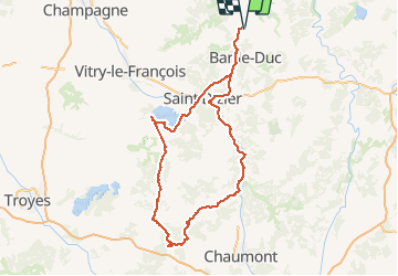
Trail Car of 248 km to be discovered at Grand Est, Meuse, Les Hauts-de-Chée. This trail is proposed by flzanichelli.
Description
Ballade de la Meuse à l'aube
La Boisserie, le mémorial de Charles De Gaulle, la croix de Lorraine. L' Abbaye de Clairevaux. Le lac du Der et ses sports nautiques...un air de vacances au bord de l'eau.
Positioning
Country:
France
Region :
Grand Est
Department/Province :
Meuse
Municipality :
Les Hauts-de-Chée
Location:
Unknown
Start:(Dec)
Start:(UTM)
658258 ; 5414625 (31U) N.
Comments
Trails nearby
![Trail Cycle Les Hauts-de-Chée - Découverte des Eoliennes - Condé-en-Barrois - Photo](https://media.geolcdn.com/t/375/260/ext.jpg?maxdim=2&url=https%3A%2F%2Fservices.sitytrail.com%2FGeolivesWS%2FDownloadMedia.ashx%3FTrailID%3D111139%26Media%3D6506_5.jpg)
![Cycle Cycle](https://static1.geolcdn.com/sitytour/trail-icons/200.png)
Découverte des Eoliennes - Condé-en-Barrois
Cycle
Medium
Les Hauts-de-Chée,
Grand Est,
Meuse,
France
![](/images/other/stat-length.png)
19.4 km | 23 km-effort
2h 0min
![](https://static1.geolcdn.com/siteimages/upload/files/16400158638029165_repeat_loop_refresh_sync_direction_icon.png)
Yes
![Trail Electric bike Les Hauts-de-Chée - Boucle Génicourt - Marat - Hargeville - Génicourt - Photo](https://media.geolcdn.com/t/375/260/ext.jpg?maxdim=2&url=https%3A%2F%2Fstatic1.geolcdn.com%2Fsiteimages%2Fupload%2Ffiles%2F1524743154velo.jpg)
![Electric bike Electric bike](https://static1.geolcdn.com/sitytour/trail-icons/205.png)
Boucle Génicourt - Marat - Hargeville - Génicourt
Electric bike
Very easy
Les Hauts-de-Chée,
Grand Est,
Meuse,
France
![](/images/other/stat-length.png)
13.6 km | 16.1 km-effort
1h 7min
![](https://static1.geolcdn.com/siteimages/upload/files/16400158638029165_repeat_loop_refresh_sync_direction_icon.png)
Yes
![Trail Other activity Les Hauts-de-Chée - Génicourt / Vavincourt - Photo](https://media.geolcdn.com/t/375/260/ext.jpg?maxdim=2&url=https%3A%2F%2Fstatic1.geolcdn.com%2Fsiteimages%2Fupload%2Ffiles%2F1545311037marcheuse_200dpi.jpg)
![Other activity Other activity](https://static1.geolcdn.com/sitytour/trail-icons/900.png)
Génicourt / Vavincourt
Other activity
Very easy
Les Hauts-de-Chée,
Grand Est,
Meuse,
France
![](/images/other/stat-length.png)
13.4 km | 15.3 km-effort
23min
![](https://static1.geolcdn.com/siteimages/upload/files/16400158638029165_repeat_loop_refresh_sync_direction_icon.png)
Yes
![Trail Mountain bike Les Hauts-de-Chée - Bel Com chez - Photo](https://media.geolcdn.com/t/375/260/ext.jpg?maxdim=2&url=https%3A%2F%2Fstatic1.geolcdn.com%2Fsiteimages%2Fupload%2Ffiles%2F1524743154velo.jpg)
![Mountain bike Mountain bike](https://static1.geolcdn.com/sitytour/trail-icons/202.png)
Bel Com chez
Mountain bike
Les Hauts-de-Chée,
Grand Est,
Meuse,
France
![](/images/other/stat-length.png)
46 km | 54 km-effort
3h 25min
![](https://static1.geolcdn.com/siteimages/upload/files/16400158638029165_repeat_loop_refresh_sync_direction_icon.png)
Yes
![Trail Walking Vavincourt - vavincourt-gare meuse TGV - Photo](https://media.geolcdn.com/t/375/260/ext.jpg?maxdim=2&url=https%3A%2F%2Fstatic1.geolcdn.com%2Fsiteimages%2Fupload%2Ffiles%2F1553511878bg_sport_marche.png)
![Walking Walking](https://static1.geolcdn.com/sitytour/trail-icons/101.png)
vavincourt-gare meuse TGV
Walking
Medium
Vavincourt,
Grand Est,
Meuse,
France
![](/images/other/stat-length.png)
26 km | 32 km-effort
6h 8min
![](https://static1.geolcdn.com/siteimages/upload/files/16400158638029165_repeat_loop_refresh_sync_direction_icon.png)
No
![Trail Electric bike Les Hauts-de-Chée - De Génicourt à la forêt de Rosnes - Photo](https://media.geolcdn.com/t/375/260/ext.jpg?maxdim=2&url=https%3A%2F%2Fstatic1.geolcdn.com%2Fsiteimages%2Fupload%2Ffiles%2F1524743154velo.jpg)
![Electric bike Electric bike](https://static1.geolcdn.com/sitytour/trail-icons/205.png)
De Génicourt à la forêt de Rosnes
Electric bike
Very easy
Les Hauts-de-Chée,
Grand Est,
Meuse,
France
![](/images/other/stat-length.png)
21 km | 25 km-effort
1h 28min
![](https://static1.geolcdn.com/siteimages/upload/files/16400158638029165_repeat_loop_refresh_sync_direction_icon.png)
No
![Trail Horseback riding Chardogne - rando Chardogne/conde/remb/vaub - Photo](https://media.geolcdn.com/t/375/260/ext.jpg?maxdim=2&url=https%3A%2F%2Fstatic1.geolcdn.com%2Fsiteimages%2Fupload%2Ffiles%2F1524743154cheval.jpg)
![Horseback riding Horseback riding](https://static1.geolcdn.com/sitytour/trail-icons/301.png)
rando Chardogne/conde/remb/vaub
Horseback riding
Medium
Chardogne,
Grand Est,
Meuse,
France
![](/images/other/stat-length.png)
20 km | 23 km-effort
3h 2min
![](https://static1.geolcdn.com/siteimages/upload/files/16400158638029165_repeat_loop_refresh_sync_direction_icon.png)
No
![Trail Electric bike Les Hauts-de-Chée - Aérodrome Sud Meusien - Photo](https://media.geolcdn.com/t/375/260/ext.jpg?maxdim=2&url=https%3A%2F%2Fstatic1.geolcdn.com%2Fsiteimages%2Fupload%2Ffiles%2F1524743154velo.jpg)
![Electric bike Electric bike](https://static1.geolcdn.com/sitytour/trail-icons/205.png)
Aérodrome Sud Meusien
Electric bike
Very easy
Les Hauts-de-Chée,
Grand Est,
Meuse,
France
![](/images/other/stat-length.png)
4.8 km | 5.6 km-effort
29min
![](https://static1.geolcdn.com/siteimages/upload/files/16400158638029165_repeat_loop_refresh_sync_direction_icon.png)
Yes