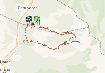
![](/images/other/stat-length.png)
![Trail On foot Beauvezer - De Villars Heyssier, Gorges de St Pierre, Cabanes de Conderman, Plateau de pisse en l'air, Cabane de l'Orgeat, Ondres - Photo](https://media.geolcdn.com/t/1900/400/6a5340de-2205-40ae-9f93-228321526560.jpg&format=pjpeg&maxdim=2)
De Villars Heyssier, Gorges de St Pierre, Cabanes de Conderman, Plateau de pisse en l'air, Cabane de l'Orgeat, Ondres
GrouGary
User
![Length](/images/other/stat-length.png)
![Max alt](https://static1.geolcdn.com/siteimages/upload/files/1508320355ic_sort_altitude_max_24dp.png)
![Uphill gradient](https://static1.geolcdn.com/siteimages/upload/files/1508320355ic_sort_den_pos_24dp.png)
![Km-Effort](/images/other/stat-length.png)
![Min alt](https://static1.geolcdn.com/siteimages/upload/files/1508320355ic_sort_altitude_min_24dp.png)
![Downhill gradient](https://static1.geolcdn.com/siteimages/upload/files/1508320355ic_sort_den_neg_24dp.png)
![Boucle](https://static1.geolcdn.com/siteimages/upload/files/16400158638029165_repeat_loop_refresh_sync_direction_icon.png)
![On foot](https://static1.geolcdn.com/sitytour/trail-icons/100.png)
--
Difficulty : Difficult
![Scan this QR Code to open this trail in the SityTrail application](https://capi.geolives.com/qq0zvz2zws4bq2lad0pu/sitytour/trails/2471538/qr.png?size=200)
FREE GPS app for hiking
About
Trail On foot of 21 km to be discovered at Provence-Alpes-Côte d'Azur, Alpes-de-Haute-Provence, Beauvezer. This trail is proposed by GrouGary.
Description
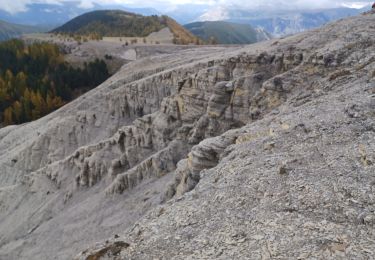
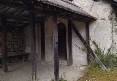
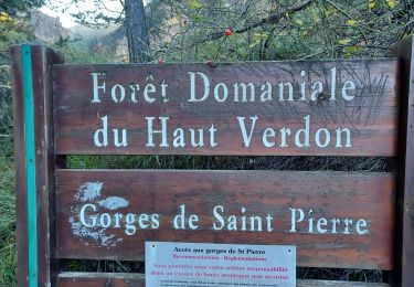
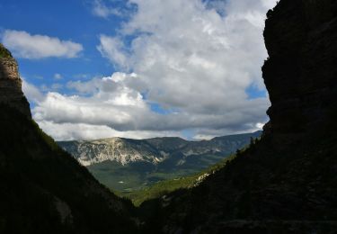
Boucle longue de 21 km ; Montée très agréable dans les fraiches Gorges de St Pierre puis Cabanes forestières de Conderman, La Baisse de l'Orgeas ; … Très nombreux Lys Martagon, Raiponces bleues, ... Chercher la sente qui monte au Plateau de Pisse en l'air (nombreux Asters, orpins…), magnifique pour le pic-nic
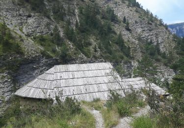
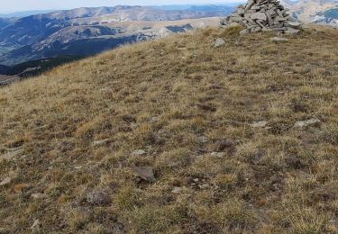
Retour à la Baisse de l'Orgeas puis descente vers la Cabane de l'Orgeat. Milieu chaud et sec où la végétation change : Nombreux Lys orangers et Raiponces mauves… Retour long.
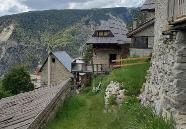
Entre la Plan et Villars Heyssier, montée pénible et chaude en fin de parcours ( 100m sur 1km)… peut-être prévoir un véhicule au Plan pour éviter cette dernière montée !
Positioning
Comments
Trails nearby
![Trail Walking Thorame-Haute - VILLARS HEYSIER .CABAN DE CONGERMAN - Photo](https://media.geolcdn.com/t/375/260/b251cad8-70ae-4895-901b-fe937d4b0df0.jpg&format=jpg&maxdim=2)
![Walking Walking](https://static1.geolcdn.com/sitytour/trail-icons/101.png)
Walking
![](/images/other/stat-length.png)
![](https://static1.geolcdn.com/siteimages/upload/files/16400158638029165_repeat_loop_refresh_sync_direction_icon.png)
![Trail Walking Beauvezer - 04.gorges st pierre 03.08.23 - Photo](https://media.geolcdn.com/t/375/260/ee41afb8-8bbb-46c3-8271-84bbc995eeab.jpg&format=jpg&maxdim=2)
![Walking Walking](https://static1.geolcdn.com/sitytour/trail-icons/101.png)
Walking
![](/images/other/stat-length.png)
![](https://static1.geolcdn.com/siteimages/upload/files/16400158638029165_repeat_loop_refresh_sync_direction_icon.png)
![Trail Walking Colmars - Les lacs Lignin - Photo](https://media.geolcdn.com/t/375/260/fbca6767-bae4-46df-a02f-745bbf118b44.jpg&format=jpg&maxdim=2)
![Walking Walking](https://static1.geolcdn.com/sitytour/trail-icons/101.png)
Walking
![](/images/other/stat-length.png)
![](https://static1.geolcdn.com/siteimages/upload/files/16400158638029165_repeat_loop_refresh_sync_direction_icon.png)
![Trail Walking Beauvezer - les gorges de St-Pierre - Photo](https://media.geolcdn.com/t/375/260/ext.jpg?maxdim=2&url=https%3A%2F%2Fservices.sitytrail.com%2FGeolivesWS%2FDownloadMedia.ashx%3FTrailID%3D793443%26Media%3Dfix__20170721123335.jpg)
![Walking Walking](https://static1.geolcdn.com/sitytour/trail-icons/101.png)
Walking
![](/images/other/stat-length.png)
![](https://static1.geolcdn.com/siteimages/upload/files/16400158638029165_repeat_loop_refresh_sync_direction_icon.png)
![Trail Walking Beauvezer - VILLARS HEYSSIER . GORGES DE SAINT PIERRE O - Photo](https://media.geolcdn.com/t/375/260/1711233c-dcfe-4507-8abf-7d44d68d7751.jpg&format=jpg&maxdim=2)
![Walking Walking](https://static1.geolcdn.com/sitytour/trail-icons/101.png)
Walking
![](/images/other/stat-length.png)
![](https://static1.geolcdn.com/siteimages/upload/files/16400158638029165_repeat_loop_refresh_sync_direction_icon.png)
![Trail Walking Colmars - Colmars petit coyer 993m 14kms - Photo](https://media.geolcdn.com/t/375/260/34cedc48-3841-4962-bcc9-facfdb32c9cc.jpg&format=jpg&maxdim=2)
![Walking Walking](https://static1.geolcdn.com/sitytour/trail-icons/101.png)
Walking
![](/images/other/stat-length.png)
![](https://static1.geolcdn.com/siteimages/upload/files/16400158638029165_repeat_loop_refresh_sync_direction_icon.png)
![Walking Walking](https://static1.geolcdn.com/sitytour/trail-icons/101.png)
Walking
![](/images/other/stat-length.png)
![](https://static1.geolcdn.com/siteimages/upload/files/16400158638029165_repeat_loop_refresh_sync_direction_icon.png)
![Trail Walking Beauvezer - villars heyssier gorges Saint Pierre 19kms 850m - Photo](https://media.geolcdn.com/t/375/260/42591c34-633f-4c89-ba92-2a0e62604bbd.jpg&format=jpg&maxdim=2)
![Walking Walking](https://static1.geolcdn.com/sitytour/trail-icons/101.png)
Walking
![](/images/other/stat-length.png)
![](https://static1.geolcdn.com/siteimages/upload/files/16400158638029165_repeat_loop_refresh_sync_direction_icon.png)
![Trail Walking Colmars - petit coyer - Photo](https://media.geolcdn.com/t/375/260/68c25c46-6e07-4761-95ca-0791cf3cb843.jpg&format=jpg&maxdim=2)
![Walking Walking](https://static1.geolcdn.com/sitytour/trail-icons/101.png)
Walking
![](/images/other/stat-length.png)
![](https://static1.geolcdn.com/siteimages/upload/files/16400158638029165_repeat_loop_refresh_sync_direction_icon.png)