![](/images/other/stat-length.png)
![Trail Walking Olargues - Boucle en passant par le mont Naudech - Photo](https://media.geolcdn.com/t/1900/400/ext.pjpeg?maxdim=2&url=https%3A%2F%2Fstatic1.geolcdn.com%2Fsiteimages%2Fupload%2Ffiles%2F1553511878bg_sport_marche.png)
Boucle en passant par le mont Naudech
DiagMan
User
![Length](/images/other/stat-length.png)
Length
10.6 km
![Max alt](https://static1.geolcdn.com/siteimages/upload/files/1508320355ic_sort_altitude_max_24dp.png)
Max alt
747 m
![Uphill gradient](https://static1.geolcdn.com/siteimages/upload/files/1508320355ic_sort_den_pos_24dp.png)
Uphill gradient
513 m
![Km-Effort](/images/other/stat-length.png)
Km-Effort
17.4 km
![Min alt](https://static1.geolcdn.com/siteimages/upload/files/1508320355ic_sort_altitude_min_24dp.png)
Min alt
367 m
![Downhill gradient](https://static1.geolcdn.com/siteimages/upload/files/1508320355ic_sort_den_neg_24dp.png)
Downhill gradient
511 m
![Boucle](https://static1.geolcdn.com/siteimages/upload/files/16400158638029165_repeat_loop_refresh_sync_direction_icon.png)
Boucle
Yes
Creation date :
2020-07-11 20:27:28.372
Updated on :
2020-07-11 20:39:29.321
![Walking](https://static1.geolcdn.com/sitytour/trail-icons/101.png)
3h34
Difficulty : Difficult
![Scan this QR Code to open this trail in the SityTrail application](https://capi.geolives.com/qq0zvz2zws4bq2lad0pu/sitytour/trails/2471325/qr.png?size=200)
FREE GPS app for hiking
About
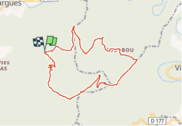
Trail Walking of 10.6 km to be discovered at Occitania, Hérault, Olargues. This trail is proposed by DiagMan.
Description
De magnifiques panoramas, notamment sur la vallée du Jaur, avec quelques beaux sous-bois. Passages un peu délicats sur la ligne de crête descendant du sommet. Le reste est facile, sur des pistes carrossables mais peu fréquentées.
Positioning
Country:
France
Region :
Occitania
Department/Province :
Hérault
Municipality :
Olargues
Location:
Unknown
Start:(Dec)
Start:(UTM)
494116 ; 4821304 (31T) N.
Comments
Trails nearby
![Trail Walking Saint-Martin-de-l'Arçon - 34 caroux - Photo](https://media.geolcdn.com/t/375/260/68524901-f808-4b7c-83cf-daed4ea0a516.jpg&format=jpg&maxdim=2)
![Walking Walking](https://static1.geolcdn.com/sitytour/trail-icons/101.png)
34 caroux
Walking
Medium
Saint-Martin-de-l'Arçon,
Occitania,
Hérault,
France
![](/images/other/stat-length.png)
13.3 km | 25 km-effort
7h 1min
![](https://static1.geolcdn.com/siteimages/upload/files/16400158638029165_repeat_loop_refresh_sync_direction_icon.png)
Yes
![Trail Walking Mons - 34 gorges Heric Mons 07.07.23 - Photo](https://media.geolcdn.com/t/375/260/06d551fc-4779-4ba0-8ab8-14fd17f32f20.jpg&format=jpg&maxdim=2)
![Walking Walking](https://static1.geolcdn.com/sitytour/trail-icons/101.png)
34 gorges Heric Mons 07.07.23
Walking
Medium
Mons,
Occitania,
Hérault,
France
![](/images/other/stat-length.png)
12.7 km | 21 km-effort
6h 2min
![](https://static1.geolcdn.com/siteimages/upload/files/16400158638029165_repeat_loop_refresh_sync_direction_icon.png)
Yes
![Trail Walking Mons - Le sentier des Gardes / Douch / Héric - Photo](https://media.geolcdn.com/t/375/260/ext.jpg?maxdim=2&url=https%3A%2F%2Fstatic1.geolcdn.com%2Fsiteimages%2Fupload%2Ffiles%2F1553511878bg_sport_marche.png)
![Walking Walking](https://static1.geolcdn.com/sitytour/trail-icons/101.png)
Le sentier des Gardes / Douch / Héric
Walking
Very difficult
(1)
Mons,
Occitania,
Hérault,
France
![](/images/other/stat-length.png)
15.2 km | 28 km-effort
6h 22min
![](https://static1.geolcdn.com/siteimages/upload/files/16400158638029165_repeat_loop_refresh_sync_direction_icon.png)
Yes
![Trail Walking Olargues - Trois jours autour d'Olargues. - Photo](https://media.geolcdn.com/t/375/260/b6fcb53a-8d47-4623-9fb0-becd4ddee877.jpg&format=jpg&maxdim=2)
![Walking Walking](https://static1.geolcdn.com/sitytour/trail-icons/101.png)
Trois jours autour d'Olargues.
Walking
Difficult
Olargues,
Occitania,
Hérault,
France
![](/images/other/stat-length.png)
25 km | 36 km-effort
7h 45min
![](https://static1.geolcdn.com/siteimages/upload/files/16400158638029165_repeat_loop_refresh_sync_direction_icon.png)
No
![Trail Walking Mons - Piste des aiguilles - Photo](https://media.geolcdn.com/t/375/260/ext.jpg?maxdim=2&url=https%3A%2F%2Fstatic1.geolcdn.com%2Fsiteimages%2Fupload%2Ffiles%2F1553511878bg_sport_marche.png)
![Walking Walking](https://static1.geolcdn.com/sitytour/trail-icons/101.png)
Piste des aiguilles
Walking
Very difficult
(1)
Mons,
Occitania,
Hérault,
France
![](/images/other/stat-length.png)
5.6 km | 13.9 km-effort
3h 2min
![](https://static1.geolcdn.com/siteimages/upload/files/16400158638029165_repeat_loop_refresh_sync_direction_icon.png)
No
![Trail Walking Saint-Martin-de-l'Arçon - Piste des triangles Bertouyre - Photo](https://media.geolcdn.com/t/375/260/ext.jpg?maxdim=2&url=https%3A%2F%2Fstatic1.geolcdn.com%2Fsiteimages%2Fupload%2Ffiles%2F1553511878bg_sport_marche.png)
![Walking Walking](https://static1.geolcdn.com/sitytour/trail-icons/101.png)
Piste des triangles Bertouyre
Walking
Difficult
(1)
Saint-Martin-de-l'Arçon,
Occitania,
Hérault,
France
![](/images/other/stat-length.png)
7.1 km | 15 km-effort
3h 2min
![](https://static1.geolcdn.com/siteimages/upload/files/16400158638029165_repeat_loop_refresh_sync_direction_icon.png)
Yes
![Trail Walking Saint-Martin-de-l'Arçon - Saint-Martin de larçon - Photo](https://media.geolcdn.com/t/375/260/ext.jpg?maxdim=2&url=https%3A%2F%2Fstatic1.geolcdn.com%2Fsiteimages%2Fupload%2Ffiles%2F1553511878bg_sport_marche.png)
![Walking Walking](https://static1.geolcdn.com/sitytour/trail-icons/101.png)
Saint-Martin de larçon
Walking
Easy
(2)
Saint-Martin-de-l'Arçon,
Occitania,
Hérault,
France
![](/images/other/stat-length.png)
6.3 km | 13.2 km-effort
2h 41min
![](https://static1.geolcdn.com/siteimages/upload/files/16400158638029165_repeat_loop_refresh_sync_direction_icon.png)
Yes
![Trail Walking Olargues - Olargues Malvies - Photo](https://media.geolcdn.com/t/375/260/ext.jpg?maxdim=2&url=https%3A%2F%2Fstatic1.geolcdn.com%2Fsiteimages%2Fupload%2Ffiles%2F1553511878bg_sport_marche.png)
![Walking Walking](https://static1.geolcdn.com/sitytour/trail-icons/101.png)
Olargues Malvies
Walking
Medium
(2)
Olargues,
Occitania,
Hérault,
France
![](/images/other/stat-length.png)
15.5 km | 23 km-effort
5h 9min
![](https://static1.geolcdn.com/siteimages/upload/files/16400158638029165_repeat_loop_refresh_sync_direction_icon.png)
Yes
![Trail Walking Olargues - Olargues - Peyro Escrito - Photo](https://media.geolcdn.com/t/375/260/2e9265ff-a018-4131-8bf8-2de990ed7413.jpg&format=jpg&maxdim=2)
![Walking Walking](https://static1.geolcdn.com/sitytour/trail-icons/101.png)
Olargues - Peyro Escrito
Walking
Very difficult
Olargues,
Occitania,
Hérault,
France
![](/images/other/stat-length.png)
16.3 km | 25 km-effort
5h 38min
![](https://static1.geolcdn.com/siteimages/upload/files/16400158638029165_repeat_loop_refresh_sync_direction_icon.png)
Yes