![](/images/other/stat-length.png)
![Trail Mountain bike Ihringen - VTT Kaiserstuhl 2020 - Photo](https://media.geolcdn.com/t/1900/400/841b7071-9ca1-4c4d-89aa-1a82c161c3c6.jpg&format=pjpeg&maxdim=2)
VTT Kaiserstuhl 2020
sit68000
User
![Length](/images/other/stat-length.png)
Length
21 km
![Max alt](https://static1.geolcdn.com/siteimages/upload/files/1508320355ic_sort_altitude_max_24dp.png)
Max alt
494 m
![Uphill gradient](https://static1.geolcdn.com/siteimages/upload/files/1508320355ic_sort_den_pos_24dp.png)
Uphill gradient
640 m
![Km-Effort](/images/other/stat-length.png)
Km-Effort
29 km
![Min alt](https://static1.geolcdn.com/siteimages/upload/files/1508320355ic_sort_altitude_min_24dp.png)
Min alt
255 m
![Downhill gradient](https://static1.geolcdn.com/siteimages/upload/files/1508320355ic_sort_den_neg_24dp.png)
Downhill gradient
640 m
![Boucle](https://static1.geolcdn.com/siteimages/upload/files/16400158638029165_repeat_loop_refresh_sync_direction_icon.png)
Boucle
Yes
Creation date :
2020-07-11 07:51:04.38
Updated on :
2020-07-11 15:00:31.134
![Mountain bike](https://static1.geolcdn.com/sitytour/trail-icons/202.png)
3h00
Difficulty : Difficult
![Scan this QR Code to open this trail in the SityTrail application](https://capi.geolives.com/qq0zvz2zws4bq2lad0pu/sitytour/trails/2470543/qr.png?size=200)
FREE GPS app for hiking
About
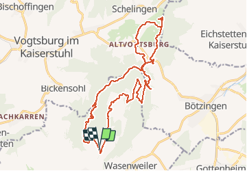
Trail Mountain bike of 21 km to be discovered at Baden-Württemberg, Landkreis Breisgau-Hochschwarzwald, Ihringen. This trail is proposed by sit68000.
Description
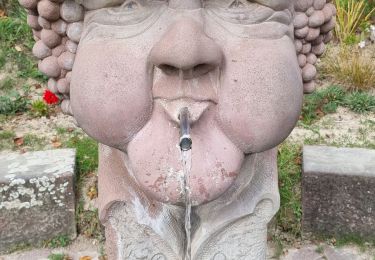
Départ du parking de l'auberge Martinshof à Ihringen vers 10h.
Retour vers 13h pour le repas.
Parcours de 3h en comptant de nombreuses pauses photos.
Positioning
Country:
Germany
Region :
Baden-Württemberg
Department/Province :
Landkreis Breisgau-Hochschwarzwald
Municipality :
Ihringen
Location:
Unknown
Start:(Dec)
Start:(UTM)
400520 ; 5323449 (32U) N.
Comments
Trails nearby
![Trail On foot Eichstetten - Geo-Pfad Eichstetten - Photo](https://media.geolcdn.com/t/375/260/4b468c13-851b-4d6b-8db8-205eaf8353d5.jpeg&format=jpg&maxdim=2)
![On foot On foot](https://static1.geolcdn.com/sitytour/trail-icons/100.png)
Geo-Pfad Eichstetten
On foot
Easy
Eichstetten,
Baden-Württemberg,
Landkreis Breisgau-Hochschwarzwald,
Germany
![](/images/other/stat-length.png)
10.4 km | 15.8 km-effort
3h 36min
![](https://static1.geolcdn.com/siteimages/upload/files/16400158638029165_repeat_loop_refresh_sync_direction_icon.png)
Yes
![Trail On foot Ihringen - Bienenfresserpfad - Photo](https://media.geolcdn.com/t/375/260/6adf0c79-1772-42f2-a9eb-4c242740bd7c.jpeg&format=jpg&maxdim=2)
![On foot On foot](https://static1.geolcdn.com/sitytour/trail-icons/100.png)
Bienenfresserpfad
On foot
Medium
Ihringen,
Baden-Württemberg,
Landkreis Breisgau-Hochschwarzwald,
Germany
![](/images/other/stat-length.png)
19 km | 26 km-effort
5h 49min
![](https://static1.geolcdn.com/siteimages/upload/files/16400158638029165_repeat_loop_refresh_sync_direction_icon.png)
No
![Trail On foot Ihringen - Kaiserstuhlpfad - Photo](https://media.geolcdn.com/t/375/260/6adf0c79-1772-42f2-a9eb-4c242740bd7c.jpeg&format=jpg&maxdim=2)
![On foot On foot](https://static1.geolcdn.com/sitytour/trail-icons/100.png)
Kaiserstuhlpfad
On foot
Easy
Ihringen,
Baden-Württemberg,
Landkreis Breisgau-Hochschwarzwald,
Germany
![](/images/other/stat-length.png)
4.6 km | 5.9 km-effort
1h 20min
![](https://static1.geolcdn.com/siteimages/upload/files/16400158638029165_repeat_loop_refresh_sync_direction_icon.png)
No
![Trail On foot Ihringen - Knabenkrautpfad - Photo](https://media.geolcdn.com/t/375/260/6adf0c79-1772-42f2-a9eb-4c242740bd7c.jpeg&format=jpg&maxdim=2)
![On foot On foot](https://static1.geolcdn.com/sitytour/trail-icons/100.png)
Knabenkrautpfad
On foot
Easy
Ihringen,
Baden-Württemberg,
Landkreis Breisgau-Hochschwarzwald,
Germany
![](/images/other/stat-length.png)
11.8 km | 15.9 km-effort
3h 37min
![](https://static1.geolcdn.com/siteimages/upload/files/16400158638029165_repeat_loop_refresh_sync_direction_icon.png)
No
![Trail On foot Eichstetten - Steinkauzpfad - Photo](https://media.geolcdn.com/t/375/260/80171f9c-fe34-43c5-b734-e6e1928b42b0.jpeg&format=jpg&maxdim=2)
![On foot On foot](https://static1.geolcdn.com/sitytour/trail-icons/100.png)
Steinkauzpfad
On foot
Easy
Eichstetten,
Baden-Württemberg,
Landkreis Breisgau-Hochschwarzwald,
Germany
![](/images/other/stat-length.png)
8.7 km | 10.8 km-effort
2h 27min
![](https://static1.geolcdn.com/siteimages/upload/files/16400158638029165_repeat_loop_refresh_sync_direction_icon.png)
No
![Trail Walking Vogtsburg im Kaiserstuhl - ARCA - Photo](https://media.geolcdn.com/t/375/260/2bd0409e-4d25-46b7-8d70-dc55faee2ab2.jpg&format=jpg&maxdim=2)
![Walking Walking](https://static1.geolcdn.com/sitytour/trail-icons/101.png)
ARCA
Walking
Easy
Vogtsburg im Kaiserstuhl,
Baden-Württemberg,
Landkreis Breisgau-Hochschwarzwald,
Germany
![](/images/other/stat-length.png)
12.9 km | 18.4 km-effort
5h 33min
![](https://static1.geolcdn.com/siteimages/upload/files/16400158638029165_repeat_loop_refresh_sync_direction_icon.png)
Yes
![Trail Walking Vogtsburg im Kaiserstuhl - Archkaren - Photo](https://media.geolcdn.com/t/375/260/ext.jpg?maxdim=2&url=https%3A%2F%2Fstatic1.geolcdn.com%2Fsiteimages%2Fupload%2Ffiles%2F1553511878bg_sport_marche.png)
![Walking Walking](https://static1.geolcdn.com/sitytour/trail-icons/101.png)
Archkaren
Walking
Medium
Vogtsburg im Kaiserstuhl,
Baden-Württemberg,
Landkreis Breisgau-Hochschwarzwald,
Germany
![](/images/other/stat-length.png)
15.6 km | 23 km-effort
5h 8min
![](https://static1.geolcdn.com/siteimages/upload/files/16400158638029165_repeat_loop_refresh_sync_direction_icon.png)
Yes
![Trail Walking Vogtsburg im Kaiserstuhl - Mondale vigne - Photo](https://media.geolcdn.com/t/375/260/ext.jpg?maxdim=2&url=https%3A%2F%2Fstatic1.geolcdn.com%2Fsiteimages%2Fupload%2Ffiles%2F1553511878bg_sport_marche.png)
![Walking Walking](https://static1.geolcdn.com/sitytour/trail-icons/101.png)
Mondale vigne
Walking
Easy
Vogtsburg im Kaiserstuhl,
Baden-Württemberg,
Landkreis Breisgau-Hochschwarzwald,
Germany
![](/images/other/stat-length.png)
9.3 km | 14.2 km-effort
3h 25min
![](https://static1.geolcdn.com/siteimages/upload/files/16400158638029165_repeat_loop_refresh_sync_direction_icon.png)
Yes
![Trail Walking Ihringen - guêpiers - Photo](https://media.geolcdn.com/t/375/260/ext.jpg?maxdim=2&url=https%3A%2F%2Fstatic1.geolcdn.com%2Fsiteimages%2Fupload%2Ffiles%2F1553511878bg_sport_marche.png)
![Walking Walking](https://static1.geolcdn.com/sitytour/trail-icons/101.png)
guêpiers
Walking
Very easy
Ihringen,
Baden-Württemberg,
Landkreis Breisgau-Hochschwarzwald,
Germany
![](/images/other/stat-length.png)
3.4 km | 4.5 km-effort
1h 2min
![](https://static1.geolcdn.com/siteimages/upload/files/16400158638029165_repeat_loop_refresh_sync_direction_icon.png)
No