![](/images/other/stat-length.png)
![Trail Walking Arâches-la-Frasse - Les crêtes des Carroz, l'Airon - Photo](https://media.geolcdn.com/t/1900/400/e57bb8ac-af5b-4ac0-b2fc-b8511a63d005.jpg&format=pjpeg&maxdim=2)
Les crêtes des Carroz, l'Airon
reneperrin
User
![Length](/images/other/stat-length.png)
![Max alt](https://static1.geolcdn.com/siteimages/upload/files/1508320355ic_sort_altitude_max_24dp.png)
![Uphill gradient](https://static1.geolcdn.com/siteimages/upload/files/1508320355ic_sort_den_pos_24dp.png)
![Km-Effort](/images/other/stat-length.png)
![Min alt](https://static1.geolcdn.com/siteimages/upload/files/1508320355ic_sort_altitude_min_24dp.png)
![Downhill gradient](https://static1.geolcdn.com/siteimages/upload/files/1508320355ic_sort_den_neg_24dp.png)
![Boucle](https://static1.geolcdn.com/siteimages/upload/files/16400158638029165_repeat_loop_refresh_sync_direction_icon.png)
![Walking](https://static1.geolcdn.com/sitytour/trail-icons/101.png)
4h47
Difficulty : Medium
![Scan this QR Code to open this trail in the SityTrail application](https://capi.geolives.com/qq0zvz2zws4bq2lad0pu/sitytour/trails/2469466/qr.png?size=200)
FREE GPS app for hiking
About
Trail Walking of 14.8 km to be discovered at Auvergne-Rhône-Alpes, Upper Savoy, Arâches-la-Frasse. This trail is proposed by reneperrin.
Description
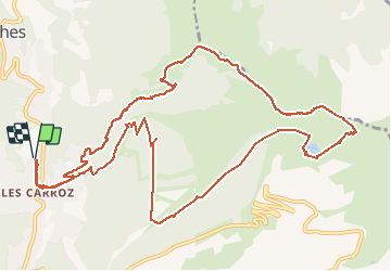
Randonnée les crêtes des Carroz
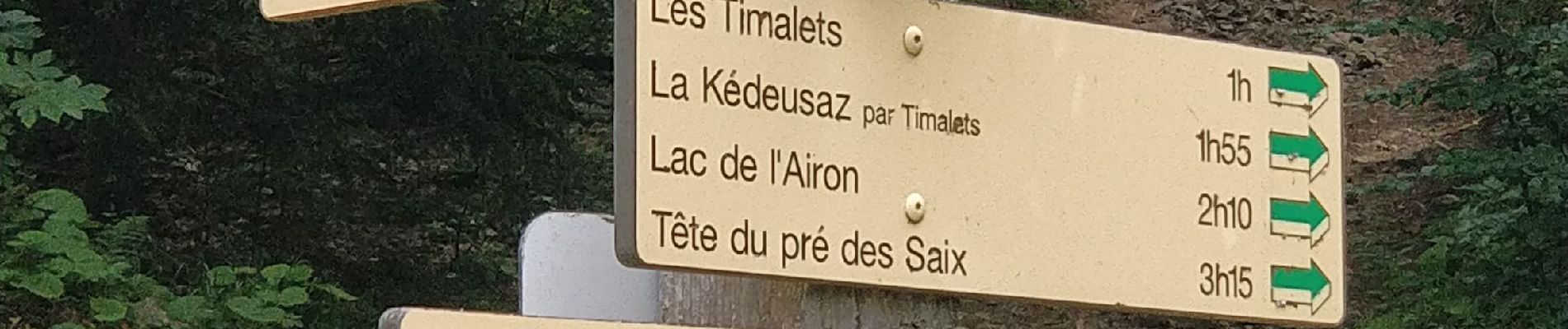
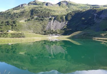
Au départ des Carroz, la montée se fait en forêt par la Pestaz et praz rôti. Ensuite une longue traversée nous amène vers l’arrête au niveau du téléski plein soleil. On suit l’arrête en lisière de forêt jusqu’à la piste forestière qui passe en-dessous de l’arrivée du télécabine Kédeusaz. Cette piste se prolonge par un agréable sentier forestier qui suit une ligne de niveau jusqu’au lac de l’Airon.
Derrière le lac une petite sente permet de remonter vers l’arrête un peu au-dessus de la pointe de la Corne. On peut monter à la pointe de la Corne, mais il est possible de redescendre par la piste. Le panorama s’ouvre sur les domaines de Samoens et Morillon.
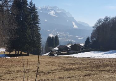
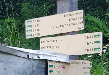
La descente se fait ensuite par les Biolaires d’où l’on voit très bien Cluses et la vallée de l’Arve. On bifurque à gauche vers les Tronchets, et on peut au lieu de suivre la piste, prendre un petit chemin forestier très agréable.qui longe le ravin du Gron jusqu’à Praz rôti. La descente se poursuit vers les Grangettes et retour aux Carroz
Positioning
Comments
Trails nearby
![Trail Walking Magland - belvédère d Aulp - Photo](https://media.geolcdn.com/t/375/260/3d7c42d4-f0a9-4769-9285-e47bef46b3ca.jpg&format=jpg&maxdim=2)
![Walking Walking](https://static1.geolcdn.com/sitytour/trail-icons/101.png)
Walking
![](/images/other/stat-length.png)
![](https://static1.geolcdn.com/siteimages/upload/files/16400158638029165_repeat_loop_refresh_sync_direction_icon.png)
![Trail Walking Samoëns - plateau des saix . la corne . les biollaires . pointe de cupoire . plateau des saix - Photo](https://media.geolcdn.com/t/375/260/9a31bcfb-eada-4e13-9da7-575e6de96d67.jpg&format=jpg&maxdim=2)
![Walking Walking](https://static1.geolcdn.com/sitytour/trail-icons/101.png)
Walking
![](/images/other/stat-length.png)
![](https://static1.geolcdn.com/siteimages/upload/files/16400158638029165_repeat_loop_refresh_sync_direction_icon.png)
![Trail Walking Cluses - 08-03-2022 Pointe du Chevran - Photo](https://media.geolcdn.com/t/375/260/6d233612-2dc0-46da-be71-d5cc509b15b1.jpg&format=jpg&maxdim=2)
![Walking Walking](https://static1.geolcdn.com/sitytour/trail-icons/101.png)
Walking
![](/images/other/stat-length.png)
![](https://static1.geolcdn.com/siteimages/upload/files/16400158638029165_repeat_loop_refresh_sync_direction_icon.png)
![Trail Walking Arâches-la-Frasse - Les Tronchets - Photo](https://media.geolcdn.com/t/375/260/1b22eca5-4d03-4493-9ac5-2c90d211f1bc.jpg&format=jpg&maxdim=2)
![Walking Walking](https://static1.geolcdn.com/sitytour/trail-icons/101.png)
Walking
![](/images/other/stat-length.png)
![](https://static1.geolcdn.com/siteimages/upload/files/16400158638029165_repeat_loop_refresh_sync_direction_icon.png)
![Trail Walking Arâches-la-Frasse - Vernant Grands Vans par le col de Véret - Photo](https://media.geolcdn.com/t/375/260/06ee9b71-5751-4664-80a4-c98989797b70.jpg&format=jpg&maxdim=2)
![Walking Walking](https://static1.geolcdn.com/sitytour/trail-icons/101.png)
Walking
![](/images/other/stat-length.png)
![](https://static1.geolcdn.com/siteimages/upload/files/16400158638029165_repeat_loop_refresh_sync_direction_icon.png)
![Trail Walking Arâches-la-Frasse - Les Carroz l'Arbaron en boucle - Photo](https://media.geolcdn.com/t/375/260/360e8a6b-b503-4616-ba4d-4d21ae7c55c0.jpg&format=jpg&maxdim=2)
![Walking Walking](https://static1.geolcdn.com/sitytour/trail-icons/101.png)
Walking
![](/images/other/stat-length.png)
![](https://static1.geolcdn.com/siteimages/upload/files/16400158638029165_repeat_loop_refresh_sync_direction_icon.png)
![Trail Walking Arâches-la-Frasse - les Carroz, tête de Saix boucle - Photo](https://media.geolcdn.com/t/375/260/fc10eab2-e7d0-43c5-ba5e-76349cca3bdc.jpg&format=jpg&maxdim=2)
![Walking Walking](https://static1.geolcdn.com/sitytour/trail-icons/101.png)
Walking
![](/images/other/stat-length.png)
![](https://static1.geolcdn.com/siteimages/upload/files/16400158638029165_repeat_loop_refresh_sync_direction_icon.png)
![Trail Walking Arâches-la-Frasse - Mont Jovy pierre à Laya - Photo](https://media.geolcdn.com/t/375/260/f39bd061-a8cf-4891-84d8-c02820fed170.jpg&format=jpg&maxdim=2)
![Walking Walking](https://static1.geolcdn.com/sitytour/trail-icons/101.png)
Walking
![](/images/other/stat-length.png)
![](https://static1.geolcdn.com/siteimages/upload/files/16400158638029165_repeat_loop_refresh_sync_direction_icon.png)
![Trail Walking Arâches-la-Frasse - randonnée en forêt, les Carroz, Araches, la Frasse - Photo](https://media.geolcdn.com/t/375/260/266ab88b-3ecc-4762-b4ff-c648b0c4392c.jpg&format=jpg&maxdim=2)
![Walking Walking](https://static1.geolcdn.com/sitytour/trail-icons/101.png)
Walking
![](/images/other/stat-length.png)
![](https://static1.geolcdn.com/siteimages/upload/files/16400158638029165_repeat_loop_refresh_sync_direction_icon.png)