Trail Walking Beaufort - La montagne d’Outray - Photo

La montagne d’Outray

© OpenStreetMap contributors
Length
Length
15.6 km
Max alt
Max alt
2191 m
Uphill gradient
Uphill gradient
1026 m
Km-Effort
Km-Effort  
29 km
Min alt
Min alt
1477 m
Downhill gradient
Downhill gradient
1039 m
Boucle
Boucle
Yes
Creation date :
2020-07-08 07:38:40.0
Updated on :
2020-07-08 16:00:15.33

(0 Reviews)

Walking
Walking
4h35
Difficulty : Very difficult

Scan this QR Code to open this trail in the SityTrail application

FREE GPS app for hiking

Logo SityTrail SityTrail

IGN / Geographical institutes

Download SityTrail from the App Store Download SityTrail from Google Play

Logo SityTrail SityTrail World

The world is yours!

Download SityTrail from the App Store Download SityTrail from Google Play Download SityTrail on Huawei AppGallery

About

Trail Walking of 15.6 km to be discovered at Auvergne-Rhône-Alpes, Savoy, Beaufort. This trail is proposed by charollois.

Description

Très bucolique avec de belles vues sur le Mont Blanc. Superbe randonnée

Elevation profile

Positioning

Country:
France
Region :
Auvergne-Rhône-Alpes
Department/Province :
Savoy
Municipality :
Beaufort
Location:
Unknown
Start:(UTM)
312856 ; 5066740 (32T) N.

Trails nearby

Trail Walking Hauteluce - sous Bisanne au lac des Saisies - Photo
Walking
syl_34

Walking

Medium
(1)
Hauteluce, Auvergne-Rhône-Alpes, Savoy, France
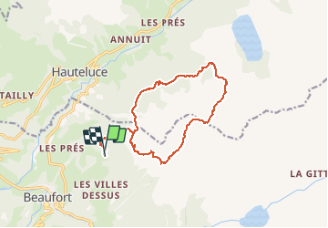
18.1 km | 28 km-effort
5h 36min
Yes
Trail Walking Beaufort - D'Arêches au Col de Pré par le hameau de Boudin - Photo
Walking
tracegps

Walking

Medium
(1)
Beaufort, Auvergne-Rhône-Alpes, Savoy, France
8.2 km | 17.9 km-effort
4h 0min
Yes
Trail Touring skiing Hauteluce - Rocher des enclaves et montagne d'outray - Photo
Touring skiing
GUIDE
nadd73

Touring skiing

Medium
Hauteluce, Auvergne-Rhône-Alpes, Savoy, France
14 km | 33 km-effort
6h 4min
Yes
Trail Touring skiing Beaufort - Côte 2000 et col de Roche plane - Photo
Touring skiing
GUIDE
nadd73

Touring skiing

Easy
Beaufort, Auvergne-Rhône-Alpes, Savoy, France
12.5 km | 29 km-effort
6h 46min
Yes
Trail Walking Hauteluce - Hauteluce - Photo
Walking
albertville

Walking

Very easy
(2)
Hauteluce, Auvergne-Rhône-Alpes, Savoy, France
4.1 km | 7.4 km-effort
1h 54min
Yes
Trail Walking Hauteluce - Mont Clocher - Photo
Walking
aglagla5

Walking

Very easy
(2)
Hauteluce, Auvergne-Rhône-Alpes, Savoy, France
7.3 km | 10.4 km-effort
1h 47min
Yes
Trail Walking Beaufort - Roche Pastrire 8,7 km - Photo
Walking
GUIDE
rvapeldo

Walking

Medium
Beaufort, Auvergne-Rhône-Alpes, Savoy, France
8.7 km | 15.3 km-effort
4h 23min
Yes
Trail Walking Beaufort - Areches col du Pré version 11 km - Photo
Walking
GUIDE
rvapeldo

Walking

Medium
(1)
Beaufort, Auvergne-Rhône-Alpes, Savoy, France
11.2 km | 21 km-effort
7h 56min
Yes
Trail Mountain bike Hauteluce - tour lac girote - Photo
Mountain bike
tintin73

Mountain bike

Medium
Hauteluce, Auvergne-Rhône-Alpes, Savoy, France
21 km | 36 km-effort
2h 20min
Yes


Close
My subscriptions