Trail Walking Rimbach-près-Masevaux - 2020-07-07 Les lac des Neuweiher et le lac des perches - Photo

2020-07-07 Les lac des Neuweiher et le lac des perches

 ABICHE
ABICHE

User

© OpenStreetMap contributors
Length
Length
13 km
Max alt
Max alt
1087 m
Uphill gradient
Uphill gradient
586 m
Km-Effort
Km-Effort  
21 km
Min alt
Min alt
536 m
Downhill gradient
Downhill gradient
586 m
Boucle
Boucle
Yes
Creation date :
2020-07-07 08:05:06.599
Updated on :
2020-07-08 07:04:58.206

(0 Reviews)

Walking
Walking
4h12
Difficulty : Medium

Scan this QR Code to open this trail in the SityTrail application

FREE GPS app for hiking

Logo SityTrail SityTrail

IGN / Geographical institutes

Download SityTrail from the App Store Download SityTrail from Google Play

Logo SityTrail SityTrail World

The world is yours!

Download SityTrail from the App Store Download SityTrail from Google Play Download SityTrail on Huawei AppGallery

About

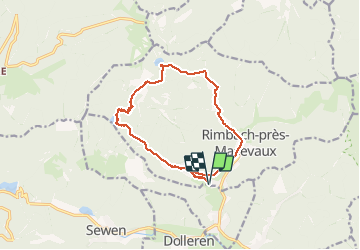
Trail Walking of 13 km to be discovered at Grand Est, Haut-Rhin, Rimbach-près-Masevaux. This trail is proposed by ABICHE.

Description

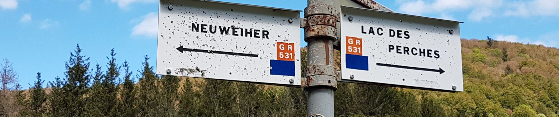
Au départ d'Ermensbach (parking obligatoire à l'entrée du village), montée aux lac des Neuweiher par le beau chemin de pierres. De là on monte au plateau qui surplombe les lacs et redescend sur le lac des perches par le rocher du corbeau. il ne reste qu'à descendre jusqu'au point de départ.

Elevation profile

Photos

Positioning

Country:
France
Region :
Grand Est
Department/Province :
Haut-Rhin
Municipality :
Rimbach-près-Masevaux
Location:
Unknown
Start:(UTM)
345796 ; 5298146 (32T) N.

Trails nearby

Trail Walking Masevaux-Niederbruck - Masevaux - Rossberg par le belvédère du Fuchsfelsen - Photo
Walking
Bart2015

Walking

Medium
(1)
Masevaux-Niederbruck, Grand Est, Haut-Rhin, France
19.9 km | 34 km-effort
4h 44min
Yes
Trail Walking Rimbach-près-Masevaux - Haute Bers - Photo
Walking
helmut68

Walking

Medium
(1)
Rimbach-près-Masevaux, Grand Est, Haut-Rhin, France
12 km | 20 km-effort
3h 25min
Yes
Trail Walking Sewen - Boucle entre les lacs de Sewen et d'Alfeld - Photo
Walking
tracegps

Walking

Medium
(1)
Sewen, Grand Est, Haut-Rhin, France
8.1 km | 12.3 km-effort
2h 30min
Yes
Trail Walking Sewen - lac d'Alfeld  - Photo
Walking
klopbill

Walking

Very difficult
(1)
Sewen, Grand Est, Haut-Rhin, France
17.1 km | 28 km-effort
8h 7min
Yes
Trail Walking Storckensohn - lac des perches marchettes - Photo
Walking
lacote

Walking

Medium
(1)
Storckensohn, Grand Est, Haut-Rhin, France
11.9 km | 20 km-effort
4h 8min
Yes
Trail Walking Storckensohn - 2022-07-16 Marche Auberge Gazon Vert Chapelle des Ves - Photo
Walking
GUIDE
holtzv

Walking

Very difficult
Storckensohn, Grand Est, Haut-Rhin, France
21 km | 37 km-effort
6h 11min
No
Trail Walking Kirchberg - 2022-07-15 Marche Refuge Baerenkopf Auberge Gazon Vert - Photo
Walking
GUIDE
holtzv

Walking

Very difficult
Kirchberg, Grand Est, Haut-Rhin, France
23 km | 38 km-effort
8h 21min
No
Trail Walking Rimbach-près-Masevaux - Les deux lacs - Photo
Walking
helmut68

Walking

Difficult
Rimbach-près-Masevaux, Grand Est, Haut-Rhin, France
15.5 km | 25 km-effort
5h 47min
Yes
Trail Walking Wegscheid - FucksfelsenBelacker - Photo
Walking
helmut68

Walking

Medium
Wegscheid, Grand Est, Haut-Rhin, France
14.4 km | 24 km-effort
4h 9min
Yes


Close
My subscriptions