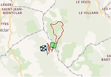
Trail Walking Seyne - 04 - près de Seyne-les-Alpes - le col bas et les 3 lacs - Photo

04 - près de Seyne-les-Alpes - le col bas et les 3 lacs

© OpenStreetMap contributors
Length
Length
12.3 km
Max alt
Max alt
2160 m
Uphill gradient
Uphill gradient
480 m
Km-Effort
Km-Effort  
18.8 km
Min alt
Min alt
1824 m
Downhill gradient
Downhill gradient
507 m
Boucle
Boucle
No
Creation date :
2020-07-05 06:45:40.908
Updated on :
2020-07-05 13:27:50.389

(1 Reviews)

Walking
Walking
4h30
Difficulty : Easy

Scan this QR Code to open this trail in the SityTrail application

FREE GPS app for hiking

Logo SityTrail SityTrail

IGN / Geographical institutes

Download SityTrail from the App Store Download SityTrail from Google Play

Logo SityTrail SityTrail World

The world is yours!

Download SityTrail from the App Store Download SityTrail from Google Play Download SityTrail on Huawei AppGallery

About

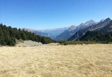
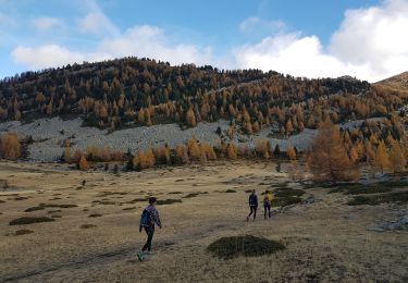
Trail Walking of 12.3 km to be discovered at Provence-Alpes-Côte d'Azur, Alpes-de-Haute-Provence, Seyne. This trail is proposed by chris13370.

Description

Belle rando malgré les teleskis du col St Jean.

Elevation profile

Photos

Positioning

Country:
France
Region :
Provence-Alpes-Côte d'Azur
Department/Province :
Alpes-de-Haute-Provence
Municipality :
Seyne
Location:
Unknown
Start:(UTM)
292262 ; 4917270 (32T) N.

Comments

Please log in to post a review or rate the element


Trails nearby

Trail Walking Ubaye-Serre-Ponçon - MONTCLAR , les Rollands  , canal de la Pisse , Pre Balou , fontaine du loup , fontaine de l mane o l m s - Photo
Walking
RobinMicheline

Walking

Medium
(1)
Ubaye-Serre-Ponçon, Provence-Alpes-Côte d'Azur, Alpes-de-Haute-Provence, France
15.6 km | 23 km-effort
4h 22min
Yes
Trail Walking Le Lauzet-Ubaye - lac noir (col du bas) - Photo
Walking
gildascb

Walking

Easy
(1)
Le Lauzet-Ubaye, Provence-Alpes-Côte d'Azur, Alpes-de-Haute-Provence, France
11.9 km | 22 km-effort
4h 29min
Yes
Trail Walking Le Lauzet-Ubaye - lac du milieu - Photo
Walking
GebleuxGaetan

Walking

Easy
(2)
Le Lauzet-Ubaye, Provence-Alpes-Côte d'Azur, Alpes-de-Haute-Provence, France
8.2 km | 15.6 km-effort
2h 53min
Yes
Trail Walking Seyne - Dormillouse, lac noir et tourbières - Photo
Walking
mc3c

Walking

Medium
(1)
Seyne, Provence-Alpes-Côte d'Azur, Alpes-de-Haute-Provence, France
12.7 km | 21 km-effort
4h 33min
Yes
Trail Walking Seyne - Dormillouse lac noir lac du milieu lac de la cabane  - Photo
Walking
GUIDE
David25400

Walking

Easy
Seyne, Provence-Alpes-Côte d'Azur, Alpes-de-Haute-Provence, France
14.3 km | 25 km-effort
3h 26min
Yes
Trail Walking Seyne - Dormillouse en boucle par le lac du Milieu - Photo
Walking
GUIDE
David25400

Walking

Easy
Seyne, Provence-Alpes-Côte d'Azur, Alpes-de-Haute-Provence, France
13.1 km | 23 km-effort
4h 33min
Yes
Trail Walking Montclar - SAINT JEAN MONTCLAR Le tour des chapelles par les chemins d autrefois  o   - Photo
Walking
RobinMicheline

Walking

Medium
(1)
Montclar, Provence-Alpes-Côte d'Azur, Alpes-de-Haute-Provence, France
14.5 km | 22 km-effort
4h 57min
Yes
Trail Walking Le Lauzet-Ubaye - Le Lauzet-Lacs col bas-20-08-2016 - Photo
Walking
GUIDE
fredetpascale

Walking

Easy
(1)
Le Lauzet-Ubaye, Provence-Alpes-Côte d'Azur, Alpes-de-Haute-Provence, France
13.2 km | 26 km-effort
4h 51min
Yes
Trail Walking Seyne - SEYNES LES ALPES . COL DE BERNARDES . PIC DE BERNARDES . PIC DE SAVERNES . COL BAS O N  - Photo
Walking
RobinMicheline

Walking

Difficult
Seyne, Provence-Alpes-Côte d'Azur, Alpes-de-Haute-Provence, France
10.4 km | 20 km-effort
3h 35min
Yes


Close
My subscriptions