![](/images/other/stat-length.png)
![Trail Walking Saint-Laurent-sur-Sèvre - Le sentier du Moulin du Guy - Photo](https://media.geolcdn.com/t/1900/400/ext.pjpeg?maxdim=2&url=https%3A%2F%2Fstatic1.geolcdn.com%2Fsiteimages%2Fupload%2Ffiles%2F1553511878bg_sport_marche.png)
Le sentier du Moulin du Guy
Gregory Herlaud
User
![Length](/images/other/stat-length.png)
Length
8 km
![Max alt](https://static1.geolcdn.com/siteimages/upload/files/1508320355ic_sort_altitude_max_24dp.png)
Max alt
158 m
![Uphill gradient](https://static1.geolcdn.com/siteimages/upload/files/1508320355ic_sort_den_pos_24dp.png)
Uphill gradient
141 m
![Km-Effort](/images/other/stat-length.png)
Km-Effort
9.9 km
![Min alt](https://static1.geolcdn.com/siteimages/upload/files/1508320355ic_sort_altitude_min_24dp.png)
Min alt
97 m
![Downhill gradient](https://static1.geolcdn.com/siteimages/upload/files/1508320355ic_sort_den_neg_24dp.png)
Downhill gradient
143 m
![Boucle](https://static1.geolcdn.com/siteimages/upload/files/16400158638029165_repeat_loop_refresh_sync_direction_icon.png)
Boucle
Yes
Creation date :
2020-07-03 18:36:47.204
Updated on :
2020-07-03 18:37:40.607
![Walking](https://static1.geolcdn.com/sitytour/trail-icons/101.png)
2h08
Difficulty : Medium
![Scan this QR Code to open this trail in the SityTrail application](https://capi.geolives.com/qq0zvz2zws4bq2lad0pu/sitytour/trails/2460616/qr.png?size=200)
FREE GPS app for hiking
About
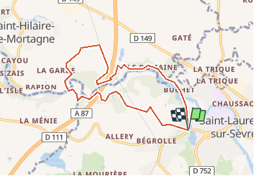
Trail Walking of 8 km to be discovered at Pays de la Loire, Vendée, Saint-Laurent-sur-Sèvre. This trail is proposed by Gregory Herlaud.
Description
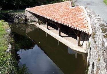
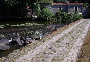
Tout en longeant la Sèvre Nantaise, découvrez la croix Brébion, la Tourette, la Porte des Martyrs et le majestueux Viaduc de Barbin
Point de départ
21 Rue de la Montforterie 85290 Saint-Laurent-sur-Sèvre
Positioning
Country:
France
Region :
Pays de la Loire
Department/Province :
Vendée
Municipality :
Saint-Laurent-sur-Sèvre
Location:
Unknown
Start:(Dec)
Start:(UTM)
659778 ; 5202772 (30T) N.
Comments
Trails nearby
![Trail Walking Mortagne-sur-Sèvre - Rando Mortagne sur Sevre 15km - Photo](https://media.geolcdn.com/t/375/260/d0282b49-5423-4aa3-8dd4-8d697928601b.jpg&format=jpg&maxdim=2)
![Walking Walking](https://static1.geolcdn.com/sitytour/trail-icons/101.png)
Rando Mortagne sur Sevre 15km
Walking
Difficult
(1)
Mortagne-sur-Sèvre,
Pays de la Loire,
Vendée,
France
![](/images/other/stat-length.png)
14.8 km | 17.8 km-effort
4h 6min
![](https://static1.geolcdn.com/siteimages/upload/files/16400158638029165_repeat_loop_refresh_sync_direction_icon.png)
Yes
![Trail Walking Cholet - Le Puy St Bonnet - St Laurent Sur Sèvre Les Balcons - Photo](https://media.geolcdn.com/t/375/260/ext.jpg?maxdim=2&url=https%3A%2F%2Fstatic1.geolcdn.com%2Fsiteimages%2Fupload%2Ffiles%2F1553511878bg_sport_marche.png)
![Walking Walking](https://static1.geolcdn.com/sitytour/trail-icons/101.png)
Le Puy St Bonnet - St Laurent Sur Sèvre Les Balcons
Walking
Easy
(2)
Cholet,
Pays de la Loire,
Maine-et-Loire,
France
![](/images/other/stat-length.png)
23 km | 28 km-effort
4h 39min
![](https://static1.geolcdn.com/siteimages/upload/files/16400158638029165_repeat_loop_refresh_sync_direction_icon.png)
Yes
![Trail Walking Saint-Laurent-sur-Sèvre - Rando St Laurent sur Sèvres 15km - Photo](https://media.geolcdn.com/t/375/260/c7b25b6b-16fe-4f42-959a-3db8fae12baf.jpg&format=jpg&maxdim=2)
![Walking Walking](https://static1.geolcdn.com/sitytour/trail-icons/101.png)
Rando St Laurent sur Sèvres 15km
Walking
Very difficult
Saint-Laurent-sur-Sèvre,
Pays de la Loire,
Vendée,
France
![](/images/other/stat-length.png)
15.4 km | 19.1 km-effort
4h 14min
![](https://static1.geolcdn.com/siteimages/upload/files/16400158638029165_repeat_loop_refresh_sync_direction_icon.png)
Yes
![Trail Walking Saint-Laurent-sur-Sèvre - ViaducBarbin - Photo](https://media.geolcdn.com/t/375/260/ext.jpg?maxdim=2&url=https%3A%2F%2Fstatic1.geolcdn.com%2Fsiteimages%2Fupload%2Ffiles%2F1553511878bg_sport_marche.png)
![Walking Walking](https://static1.geolcdn.com/sitytour/trail-icons/101.png)
ViaducBarbin
Walking
Easy
(2)
Saint-Laurent-sur-Sèvre,
Pays de la Loire,
Vendée,
France
![](/images/other/stat-length.png)
8.4 km | 10.4 km-effort
2h 17min
![](https://static1.geolcdn.com/siteimages/upload/files/16400158638029165_repeat_loop_refresh_sync_direction_icon.png)
Yes
![Trail Walking Mortagne-sur-Sèvre - Mortagbe sur Sèvre 15 km - Photo](https://media.geolcdn.com/t/375/260/a5f619e0-d31b-4e77-a119-9a1f352b2b4b.jpg&format=jpg&maxdim=2)
![Walking Walking](https://static1.geolcdn.com/sitytour/trail-icons/101.png)
Mortagbe sur Sèvre 15 km
Walking
Difficult
Mortagne-sur-Sèvre,
Pays de la Loire,
Vendée,
France
![](/images/other/stat-length.png)
15 km | 18 km-effort
4h 1min
![](https://static1.geolcdn.com/siteimages/upload/files/16400158638029165_repeat_loop_refresh_sync_direction_icon.png)
Yes
![Trail Walking Treize-Vents - rando les treize cents 18km - Photo](https://media.geolcdn.com/t/375/260/7348d043-cdab-4698-91ff-220ba9aac84e.jpg&format=jpg&maxdim=2)
![Walking Walking](https://static1.geolcdn.com/sitytour/trail-icons/101.png)
rando les treize cents 18km
Walking
Very difficult
Treize-Vents,
Pays de la Loire,
Vendée,
France
![](/images/other/stat-length.png)
19.6 km | 24 km-effort
4h 47min
![](https://static1.geolcdn.com/siteimages/upload/files/16400158638029165_repeat_loop_refresh_sync_direction_icon.png)
No
![Trail Walking Treize-Vents - treize vents Mallievre - Photo](https://media.geolcdn.com/t/375/260/51e2291d-e12b-49f3-948f-44d737b92c39.jpg&format=jpg&maxdim=2)
![Walking Walking](https://static1.geolcdn.com/sitytour/trail-icons/101.png)
treize vents Mallievre
Walking
Very difficult
Treize-Vents,
Pays de la Loire,
Vendée,
France
![](/images/other/stat-length.png)
18.1 km | 23 km-effort
4h 51min
![](https://static1.geolcdn.com/siteimages/upload/files/16400158638029165_repeat_loop_refresh_sync_direction_icon.png)
No
![Trail Walking Saint-Laurent-sur-Sèvre - saint laurent sur sevre - Photo](https://media.geolcdn.com/t/375/260/d247702a-eb5a-429d-9027-07e5d3f199a5.jpg&format=jpg&maxdim=2)
![Walking Walking](https://static1.geolcdn.com/sitytour/trail-icons/101.png)
saint laurent sur sevre
Walking
Difficult
Saint-Laurent-sur-Sèvre,
Pays de la Loire,
Vendée,
France
![](/images/other/stat-length.png)
14 km | 17.4 km-effort
3h 52min
![](https://static1.geolcdn.com/siteimages/upload/files/16400158638029165_repeat_loop_refresh_sync_direction_icon.png)
No
![Trail Mountain bike Mortagne-sur-Sèvre - La Mortagnaise 2009 - Photo](https://media.geolcdn.com/t/375/260/ext.jpg?maxdim=2&url=https%3A%2F%2Fservices.sitytrail.com%2FGeolivesWS%2FDownloadMedia.ashx%3FTrailID%3D104021%26Media%3D6982_1.jpg)
![Mountain bike Mountain bike](https://static1.geolcdn.com/sitytour/trail-icons/202.png)
La Mortagnaise 2009
Mountain bike
Difficult
(1)
Mortagne-sur-Sèvre,
Pays de la Loire,
Vendée,
France
![](/images/other/stat-length.png)
26 km | 33 km-effort
2h 30min
![](https://static1.geolcdn.com/siteimages/upload/files/16400158638029165_repeat_loop_refresh_sync_direction_icon.png)
No