![](/images/other/stat-length.png)
![Trail Mountain bike La Môle - Tour du lac de la Verne départ Pachacaïd - Photo](https://media.geolcdn.com/t/1900/400/f3c2223d-afdd-4d5a-ac01-973b4b64314f.jpg&format=pjpeg&maxdim=2)
Tour du lac de la Verne départ Pachacaïd
Jerome Lison
User
![Length](/images/other/stat-length.png)
![Max alt](https://static1.geolcdn.com/siteimages/upload/files/1508320355ic_sort_altitude_max_24dp.png)
![Uphill gradient](https://static1.geolcdn.com/siteimages/upload/files/1508320355ic_sort_den_pos_24dp.png)
![Km-Effort](/images/other/stat-length.png)
![Min alt](https://static1.geolcdn.com/siteimages/upload/files/1508320355ic_sort_altitude_min_24dp.png)
![Downhill gradient](https://static1.geolcdn.com/siteimages/upload/files/1508320355ic_sort_den_neg_24dp.png)
![Boucle](https://static1.geolcdn.com/siteimages/upload/files/16400158638029165_repeat_loop_refresh_sync_direction_icon.png)
![Mountain bike](https://static1.geolcdn.com/sitytour/trail-icons/202.png)
1h43
Difficulty : Medium
![Scan this QR Code to open this trail in the SityTrail application](https://capi.geolives.com/qq0zvz2zws4bq2lad0pu/sitytour/trails/2459663/qr.png?size=200)
FREE GPS app for hiking
About
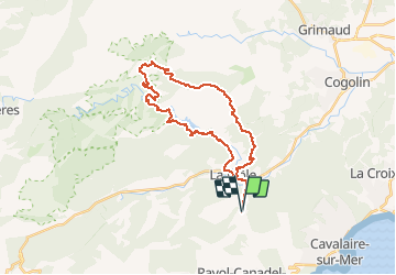
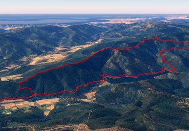
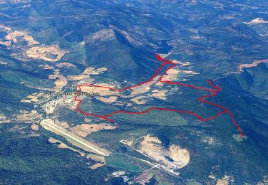
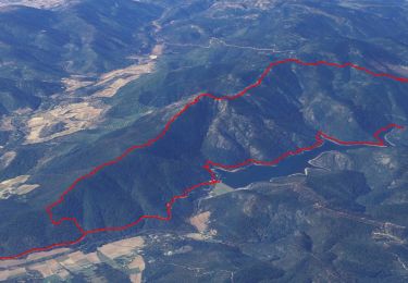
Trail Mountain bike of 30 km to be discovered at Provence-Alpes-Côte d'Azur, Var, La Môle. This trail is proposed by Jerome Lison.
Description
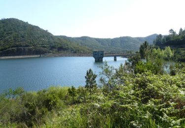
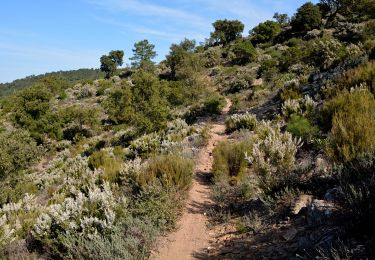
Superbe Rando, 10 km d'effort où vous prenez 400m de D ! pour un réel plaisir de descente et des paysages magnifiques.
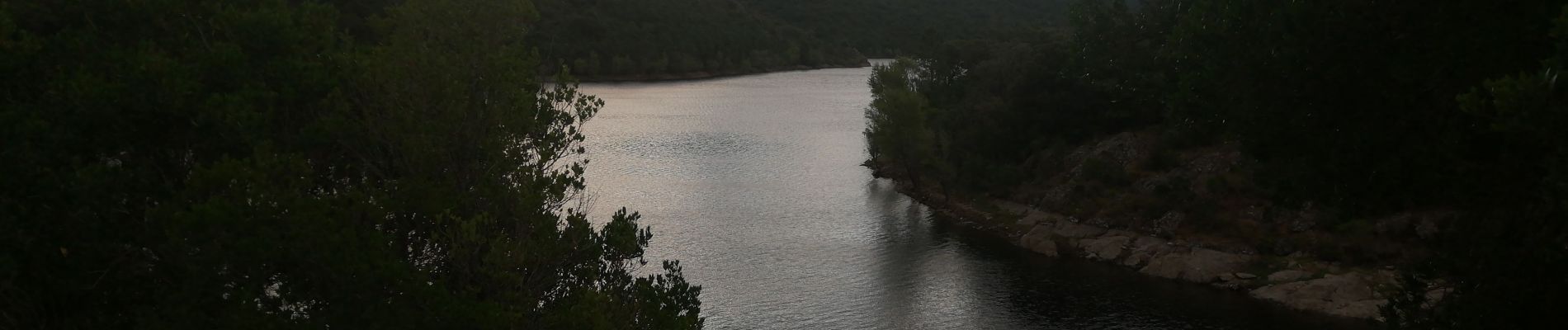
Vous passez dans la zone protégée du lac de la Verne où vous pourriez y trouver panneau d'interdiction ou barrière fermée : passez de côté, vous n'êtes pas en infraction, les Vélos sont autorisés
Positioning
Comments
Trails nearby
![Trail Walking La Môle - SityTrail - Barrage de la verne - Sommet de l'Argentière par les crêtes des Pradets - Retour par le bord du lac - Photo](https://media.geolcdn.com/t/375/260/760c7a83-a4d8-41d7-9ea7-3093b4adef8e.jpg&format=jpg&maxdim=2)
![Walking Walking](https://static1.geolcdn.com/sitytour/trail-icons/101.png)
Walking
![](/images/other/stat-length.png)
![](https://static1.geolcdn.com/siteimages/upload/files/16400158638029165_repeat_loop_refresh_sync_direction_icon.png)
![Trail Walking La Môle - SityTrail - SityTrail - la mole - Photo](https://media.geolcdn.com/t/375/260/0ba0349d-6bb2-4249-b45a-746244491cb5.jpg&format=jpg&maxdim=2)
![Walking Walking](https://static1.geolcdn.com/sitytour/trail-icons/101.png)
Walking
![](/images/other/stat-length.png)
![](https://static1.geolcdn.com/siteimages/upload/files/16400158638029165_repeat_loop_refresh_sync_direction_icon.png)
![Trail Walking La Môle - Rando Chartreuse de la Verne - Photo](https://media.geolcdn.com/t/375/260/ext.jpg?maxdim=2&url=https%3A%2F%2Fservices.sitytrail.com%2FGeolivesWS%2FDownloadMedia.ashx%3FTrailID%3D103792%26Media%3D6562_1.jpg)
![Walking Walking](https://static1.geolcdn.com/sitytour/trail-icons/101.png)
Walking
![](/images/other/stat-length.png)
![](https://static1.geolcdn.com/siteimages/upload/files/16400158638029165_repeat_loop_refresh_sync_direction_icon.png)
![Trail Walking Le Lavandou - Balcons de Pramousquier 22.1.23 - Photo](https://media.geolcdn.com/t/375/260/b49f05a7-2e02-450b-a614-7cc169048d9c.jpg&format=jpg&maxdim=2)
![Walking Walking](https://static1.geolcdn.com/sitytour/trail-icons/101.png)
Walking
![](/images/other/stat-length.png)
![](https://static1.geolcdn.com/siteimages/upload/files/16400158638029165_repeat_loop_refresh_sync_direction_icon.png)
![Trail Walking La Môle - Barrage de la verne - Sommet de l'Argentière par les crêtes des Pradets - Retour par le bord du lac (V1) - Photo](https://media.geolcdn.com/t/375/260/84190798-1374-481e-8920-bdcbb144aaf2.jpg&format=jpg&maxdim=2)
![Walking Walking](https://static1.geolcdn.com/sitytour/trail-icons/101.png)
Walking
![](/images/other/stat-length.png)
![](https://static1.geolcdn.com/siteimages/upload/files/16400158638029165_repeat_loop_refresh_sync_direction_icon.png)
![Trail Mountain bike La Môle - VTT - La Mole - Barrage de La Verne - Chartreuse de La Verne - Capelude - Retour La Mole par les crêtes - Photo](https://media.geolcdn.com/t/375/260/977ec82e-6359-4a66-ab94-b782942b304d.jpg&format=jpg&maxdim=2)
![Mountain bike Mountain bike](https://static1.geolcdn.com/sitytour/trail-icons/202.png)
Mountain bike
![](/images/other/stat-length.png)
![](https://static1.geolcdn.com/siteimages/upload/files/16400158638029165_repeat_loop_refresh_sync_direction_icon.png)
![Trail Walking Rayol-Canadel-sur-Mer - Wikiloc - Le rayon canadel - Opidum de monjean - Photo](https://media.geolcdn.com/t/375/260/4e43ac4c-7667-474b-8d0a-9263d51cfdde.jpg&format=jpg&maxdim=2)
![Walking Walking](https://static1.geolcdn.com/sitytour/trail-icons/101.png)
Walking
![](/images/other/stat-length.png)
![](https://static1.geolcdn.com/siteimages/upload/files/16400158638029165_repeat_loop_refresh_sync_direction_icon.png)
![Trail Walking Le Lavandou - cavaliere - Photo](https://media.geolcdn.com/t/375/260/ext.jpg?maxdim=2&url=https%3A%2F%2Fstatic1.geolcdn.com%2Fsiteimages%2Fupload%2Ffiles%2F1553511878bg_sport_marche.png)
![Walking Walking](https://static1.geolcdn.com/sitytour/trail-icons/101.png)
Walking
![](/images/other/stat-length.png)
![](https://static1.geolcdn.com/siteimages/upload/files/16400158638029165_repeat_loop_refresh_sync_direction_icon.png)
![Trail Walking Rayol-Canadel-sur-Mer - 20190222 rayol canadel - Photo](https://media.geolcdn.com/t/375/260/ext.jpg?maxdim=2&url=https%3A%2F%2Fstatic1.geolcdn.com%2Fsiteimages%2Fupload%2Ffiles%2F1553511878bg_sport_marche.png)
![Walking Walking](https://static1.geolcdn.com/sitytour/trail-icons/101.png)
Walking
![](/images/other/stat-length.png)
![](https://static1.geolcdn.com/siteimages/upload/files/16400158638029165_repeat_loop_refresh_sync_direction_icon.png)