Trail Walking Fréjus - Nénuphares - Photo
© OpenStreetMap contributors
Length
Length
6.5 km
Max alt
Max alt
126 m
Uphill gradient
Uphill gradient
128 m
Km-Effort
Km-Effort  
8.2 km
Min alt
Min alt
25 m
Downhill gradient
Downhill gradient
129 m
Boucle
Boucle
Yes
Creation date :
2020-07-02 15:29:11.608
Updated on :
2020-07-02 15:43:35.755

(0 Reviews)

Walking
Walking
1h46
Difficulty : Medium

Scan this QR Code to open this trail in the SityTrail application

FREE GPS app for hiking

Logo SityTrail SityTrail

IGN / Geographical institutes

Download SityTrail from the App Store Download SityTrail from Google Play

Logo SityTrail SityTrail World

The world is yours!

Download SityTrail from the App Store Download SityTrail from Google Play Download SityTrail on Huawei AppGallery

About

Trail Walking of 6.5 km to be discovered at Provence-Alpes-Côte d'Azur, Var, Fréjus. This trail is proposed by marcheetnature.

Description

Facile, à l'exception d'une montée de 200 mètres sans grande difficulté.
Cette difficulté se situe au retour du plan d'eau "Saint - Esprit," sur le cours d'eau du même nom. Départ et arrivée, Parking de la Via Aurélia, angle rue des Pyracanthas, Tour de Mare à FREJUS.

Elevation profile

Positioning

Country:
France
Region :
Provence-Alpes-Côte d'Azur
Department/Province :
Var
Municipality :
Fréjus
Location:
Unknown
Start:(UTM)
318929 ; 4813995 (32T) N.

Trails nearby

Trail Walking Fréjus - Lac de l'Avelan au départ du col d'Auriasque - Photo
Walking
LtZIP

Walking

Easy
(2)
Fréjus, Provence-Alpes-Côte d'Azur, Var, France
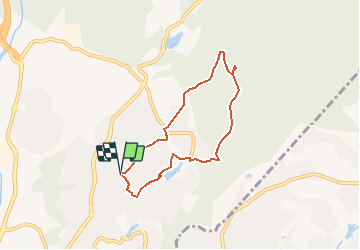
16.6 km | 23 km-effort
5h 39min
Yes
Trail Walking Fréjus - z l'Estarpe 13-11-18 - Photo
Walking
cb8310

Walking

Easy
(1)
Fréjus, Provence-Alpes-Côte d'Azur, Var, France
6.6 km | 8.2 km-effort
1h 51min
Yes
Trail Mountain bike Fréjus - grand tour esterel par belles pistes larges - Photo
Mountain bike
Margaide

Mountain bike

Easy
(2)
Fréjus, Provence-Alpes-Côte d'Azur, Var, France
31 km | 40 km-effort
3h 17min
Yes
Trail Mountain bike Puget-sur-Argens - Forêt de la Colle du Rouet aux Gorges de Blavet - Fréjus - Photo
Mountain bike
tracegps

Mountain bike

Difficult
(1)
Puget-sur-Argens, Provence-Alpes-Côte d'Azur, Var, France
23 km | 28 km-effort
3h 0min
Yes
Trail Walking Fréjus - Mont Vinaigre par Colle Douce - Photo
Walking

Walking

Very difficult
(1)
Fréjus, Provence-Alpes-Côte d'Azur, Var, France
22 km | 33 km-effort
6h 1min
Yes
Trail Walking Fréjus - Mont Vinaigre - Photo
Walking
i20

Walking

Easy
(1)
Fréjus, Provence-Alpes-Côte d'Azur, Var, France
7.8 km | 11.9 km-effort
Unknown
Yes
Trail Walking Fréjus - Sortie du lundi 8 janvier aprés-midi - Photo
Walking
OB83700

Walking

Medium
(1)
Fréjus, Provence-Alpes-Côte d'Azur, Var, France
7.4 km | 10.7 km-effort
2h 50min
Yes
Trail On foot Saint-Raphaël - St RAPHAEL-Les lacs- l Essuyadou le Vallon du Cabre-DRI - Photo
On foot

On foot

Easy
(1)
Saint-Raphaël, Provence-Alpes-Côte d'Azur, Var, France
10.2 km | 13.1 km-effort
2h 58min
Yes
Trail Walking Saint-Raphaël - Peïre Sarade à Ancienne Carrière de Dramont - Photo
Walking
LtZIP

Walking

Very easy
(1)
Saint-Raphaël, Provence-Alpes-Côte d'Azur, Var, France
13.6 km | 19.5 km-effort
4h 4min
Yes


Close
My subscriptions